Annual erosion sediment yield model calculation method of mesoscale drainage basin of loess plateau

A technology of the Loess Plateau and calculation methods, applied in the direction of calculation, special data processing applications, instruments, etc., can solve problems such as inability to reflect project requirements, algorithm difficulties, and collection difficulties

Inactive Publication Date: 2014-07-23
NORTHWEST A & F UNIV
View PDF4 Cites 17 Cited by
  • Summary
  • Abstract
  • Description
  • Claims
  • Application Information

AI Technical Summary

Problems solved by technology

[0004] The disadvantage is that it cannot reflect the requirements of the project (develop an empirical model of annual sand production based on GIS); the operation results are mainly tables about the overall characteristics of soil erosion in the watershed, which cannot meet the needs of water and soil conservation measures; it needs to be based on a relatively large amount of hydrological data , it is more difficult to collect; at the same time, because there is no measured data for a specific single factor (other factors remain unchanged), it is still difficult to determine the algorithm of each factor, which also makes the transplantation of the model from one watershed to another watershed difficult. limit

Method used


Image

  • Annual erosion sediment yield model calculation method of mesoscale drainage basin of loess plateau
  • Annual erosion sediment yield model calculation method of mesoscale drainage basin of loess plateau
  • Annual erosion sediment yield model calculation method of mesoscale drainage basin of loess plateau

Examples


Embodiment Construction

[0070] The above and other technical features and advantages of the present invention will be described in more detail below in conjunction with the accompanying drawings.

[0071] The calculation method of the annual erosion and sediment yield model of the mesoscale watershed in the Loess Plateau of the present invention is based on the distributed annual erosion and sediment yield model, and the calculation process of the model is:

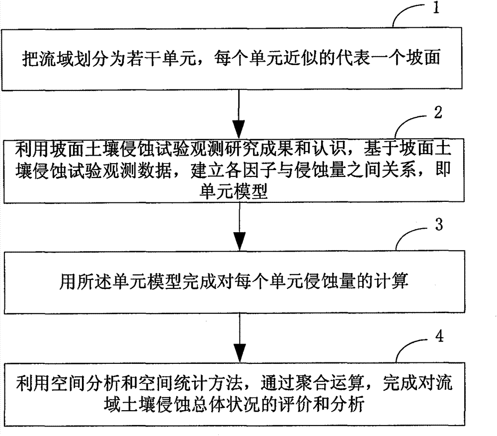
[0072] Step 1, divide the watershed into several units, and each unit approximately represents a slope;

[0073] Step 2, using the observation and research results and knowledge of the slope soil erosion test, and based on the observation data of the slope soil erosion test, establish the relationship between each factor and the amount of erosion—the unit model;

[0074] Step 3, use the unit model to complete the calculation of the erosion amount of each unit;

[0075] Step 4, using spatial analysis and spatial statistics methods, through aggre...


PUM


Abstract

The invention relates to an annual erosion sediment yield model calculation method of a mesoscale drainage basin of the loess plateau. The method includes the concrete steps that the drainage basin is divided into a plurality of units, and each unit approximately represents one slope surface; through the slope surface soil erosion test observation and research result and knowledge, relations between all factors and the erosion amount, namely unit models, are established based on slope surface soil erosion test observation data; the erosion amount of each unit is calculated through the unit models; with a spatial analysis and spatial statistical method, the overall conditions of soil erosion of the drainage basin are evaluated and analyzed through clustering operation. According to the method, the GIS spatial analysis function is fully utilized, the output results of the method can give out the erosion intensities of all portions in the drainage basin, and thus not only can the requirements of channel water conservancy engineering design be met, but also the demand for arrangement and planning of water and soil conservation measures can be met.

Description

technical field [0001] The invention relates to the field of regional soil erosion, in particular to a method for calculating annual erosion and sediment yield models of mesoscale watersheds in the Loess Plateau. Background technique [0002] In the prior art, the regional scale application and improvement of model systems for soil and water conservation planning and design, soil and water conservation measure benefit assessment, and tributary-scale soil and water loss investigation and monitoring are of great significance to soil determination. [0003] The lumped model is based on GIS to establish a database of soil erosion factors. In the thematic map, through spatial statistical analysis, one or several statistical feature values ​​of each factor are obtained to characterize the factor characteristics at the watershed scale. Then correlate the erosion factor values ​​of all watersheds with the sediment discharge data obtained from hydrological observations, establish an ...

Claims


Application Information

Patent Timeline
Patent Type & Authority Applications(China)
IPC IPC(8): G06F19/00
Inventor 张宏鸣杨勤科李书琴韩文霆黄玉祥王美丽刘晴蕊程琳
Owner NORTHWEST A & F UNIV
Why Eureka
Try Eureka