
Method for extracting tree height from laser radar Gaussian echo data

A technology of laser radar and echo data, which is applied in the field of remote sensing surveying and mapping, can solve the problems of tree height error, Gaussian echo data influence, and the position of the ground echo peak is not obvious, so as to achieve the effect of reducing sensitivity and improving accuracy

Inactive Publication Date: 2014-09-24
董立新
View PDF2 Cites 16 Cited by
  • Summary
  • Abstract
  • Description
  • Claims
  • Application Information

AI Technical Summary

Problems solved by technology

[0004] However, studies have shown that when the slope reaches a certain level, the Gaussian echo data will be greatly affected (Harding, 1994; Heyder, 2005)
Generally, when there is a slope on the ground, the position of the peak of the ground echo is not obvious. At this time, directly using this method to extract the tree height from the waveform data will cause a large error
The main reason is that when the slope of the terrain exceeds a certain range, the ground echo and the vegetation echo are mixed together, and the attenuation of the lidar sensor makes it difficult to obtain and decompose the echo
Especially at present, many experiments in this area are obtained and completed in the relatively flat terrain of North America. In comparison, the terrain in some parts of China is more undulating, and there may be some problems in the existing data extraction algorithms. Not applicable

Method used


Image

  • Method for extracting tree height from laser radar Gaussian echo data
  • Method for extracting tree height from laser radar Gaussian echo data
  • Method for extracting tree height from laser radar Gaussian echo data

Examples


Embodiment 1

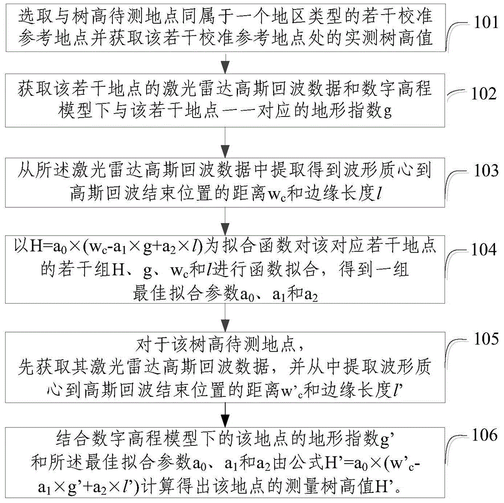
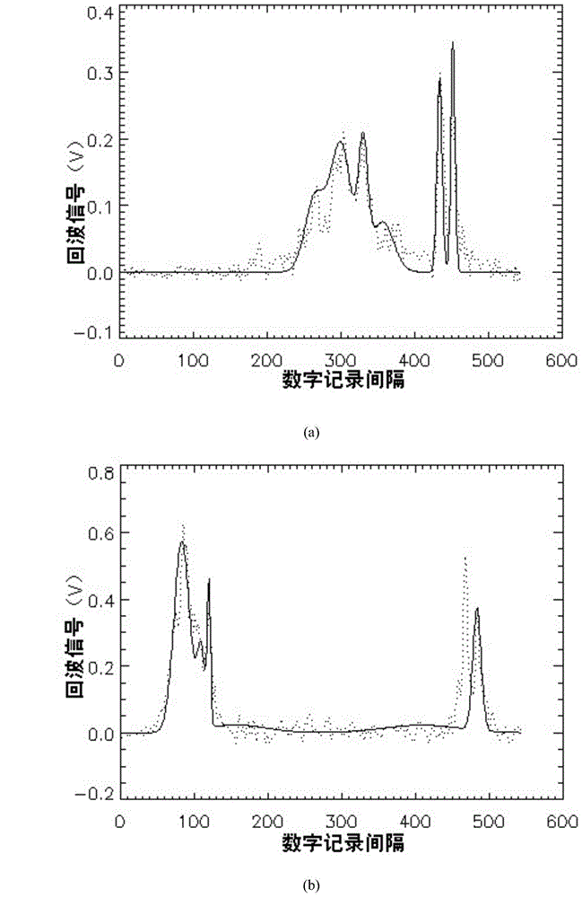
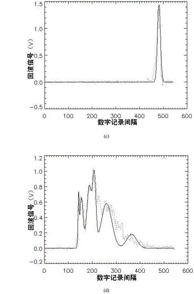
[0032] Embodiment 1: The embodiment of the present invention proposes a method for extracting tree height from lidar Gaussian echo data, and demonstrates the tree height extraction process using GLAS Gaussian echo data in the Three Gorges area. see figure 1 , the method includes:

[0033] Step 101: select a number of calibration reference sites that belong to the same area type as the tree height measurement site, and obtain the measured tree height values ​​at the several calibration reference sites;

[0034] In actual operation, the measured tree height H as reference data can be obtained by many means. For example, in the embodiment of the present invention, the method of on-the-spot measurement is adopted, and several sampling points in the Three Gorges Reservoir area are located at the foot of GLAS. as calibration reference sites, and tree height measurements were taken at these sites. And in the embodiment of the present invention, the "same area type" specifically ref...


PUM


Abstract

The invention relates to the field of remote sense surveying and mapping and provides a method for extracting tree height from laser radar Gaussian echo data. The method comprises the steps of: selecting a plurality of calibration reference sites belonging to the same region type with a site where the tree height is to be measured; extracting a distance wc from a waveform centroid to an echo end position and an edge length l from the laser radar Gaussian echo data according to actual tree height values H corresponding to the plurality of sites one by one and a terrain index g under a digital elevation model; performing function fitting on H that is equal to a0*(wc-a1*g+a2*l) to obtain a group of best fitting parameters a0, a1 and a2; working out the tree height measured value H' of the site where the tree height is to be measured by a formula, H' is equal to a0*(w'c-a1*g'+a2*l'), according to the distance w'c from the waveform centroid to the echo end position, the edge length l', the terrain index g' of the site and the best fitting parameters a0, a1 and a2. According to the method, the tree height can be extracted from laser radar Gaussian echo data of large slope regions.

Description

technical field [0001] The invention relates to the field of remote sensing surveying and mapping, in particular to a method for extracting tree height from laser radar Gaussian echo data. Background technique [0002] As an active remote sensing device using photoelectric detection technology, lidar is widely used in forestry, surveying and mapping and other fields due to its high resolution. For example, GLAS (Geoscience Laser Altimeter System, Earth Science Laser Altimeter System), the first spaceborne lidar sensor mounted on the scientific experiment satellite ICEsat launched by the United States in 2003, can continuously obtain echo data of the atmosphere and the ground. The digitizer records the echo signal (time-intensity curve) within 765km from the satellite to the surface. After filtering and analysis, the transmitted pulse and surface echo can be extracted. Its 1064nm band echo data contains vertical structure information including height information. The resear...

Claims


Application Information

Patent Timeline
IPC IPC(8): G01S7/493G01S7/497
CPCG01S7/487G01S17/88
Inventor 董立新
Owner 董立新
Learn More