A Method for Preparation of Surface Observation Air Temperature Spatio-temporal Dataset

A spatio-temporal data and data preparation technology, applied in the field of geosciences, can solve the problems of varying degrees of detail, effective coupling and integration of methods that have not been considered systematically, and discrete problems

Active Publication Date: 2017-08-15
NORTHWEST INST OF ECO ENVIRONMENT & RESOURCES CAS
View PDF0 Cites 0 Cited by
  • Summary
  • Abstract
  • Description
  • Claims
  • Application Information

AI Technical Summary

Problems solved by technology

[0004] The air temperature data comes from the ground observation network, such as meteorological stations, hydrological stations, ecological observation stations, and some temporary sampling points. Although these stations are generally more and more dense, due to the limitations of observation methods, resource allocation, and regional characteristics, we It is impossible to establish observation stations or set up observation instruments for each geographical grid point (or belt), especially in remote areas, where the distribution of geoscience observation stations is very sparse, for example, there are less than 200 national meteorological stations in the five provinces and regions of Northwest China, so we can generally only get Discrete, irregularly distributed, and varying degrees of detail observation point (or sampling point) data
These methods only conduct theoretical verification research and application on a certain aspect of the spatio-temporal characteristics of environmental observation elements, but do not consider the effective coupling and integration of methods from a systematic perspective, forming a spatio-temporal analysis system of environmental observation elements, especially future situation prediction , so far there is no effective method for preparing surface-observed air temperature spatio-temporal datasets

Method used


Image

  • A Method for Preparation of Surface Observation Air Temperature Spatio-temporal Dataset
  • A Method for Preparation of Surface Observation Air Temperature Spatio-temporal Dataset
  • A Method for Preparation of Surface Observation Air Temperature Spatio-temporal Dataset

Examples


Embodiment Construction

[0069] The present invention is described in detail below in conjunction with accompanying drawing and specific embodiment:

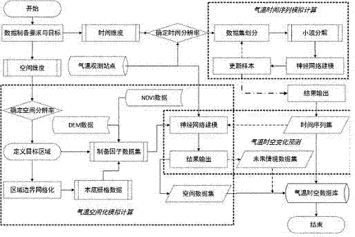
[0070] The invention discloses a preparation method of surface observation air temperature spatio-temporal data set, which includes the following parts: first, define and determine the research area, form background grid data, preprocess the air temperature data, prepare background grid data, and prepare macro geographic Factors (geographical location, topography, natural geographical environment) and micro-geographical factors (slope, aspect, small terrain form, vegetation, soil, shade) and other driving data sets, through comparative analysis, the longitude, latitude, altitude ( Elevation), slope, slope aspect and vegetation coverage index have an important influence on the spatial distribution of temperature; secondly, a wavelet neural network dynamic prediction model is constructed to analyze the change characteristics and trend prediction of tempera...


PUM


Abstract

The invention discloses a preparation method of a ground-based observation air temperature space-time data set. The method comprises the following steps: firstly determining space-time resolution ratio and area range of a precast data set; preprocessing air temperature observation data so as to form a normative driving data set; preparing a macro geographic factor and microcosmic geographic factor grid data set of a research area so as to enable the macro geographic factor and microcosmic geographic factor grid data set to correspond to the space-time resolution ratio of the research area; constructing a wavelet neural network dynamic combined prediction model in the time dimension, performing simulation prediction on the change characteristics of air temperature data so as to form a future air temperature change time sequence set; calculating air temperature numerical values of grids in a target area one by one in the space dimension, so as to generate a spatial data set of air temperature spatial change trends; performing simulation calculation on air temperature in the time dimension and the space dimension simultaneously based on key influence factors so as to generate an air temperature future space-time change scene predication data set. The preparation method has favorable expansibility and can be popularized and applied to preparation and production of space-time data products of other observation elements of a geoscience station.

Description

technical field [0001] The invention relates to the fields of data mining, data fusion and data preparation in the field of geosciences, and specifically relates to a method for preparing a ground observation air temperature spatio-temporal data set. Background technique [0002] Air temperature has an important impact on human and natural systems. As a comprehensive environmental index reflecting the heat status of the earth's surface system, it is not only a key indicator to participate in the division of natural territorial system boundaries, but also an important parameter for the simulation of land surface process models. Therefore, air temperature is It is widely used in various fields of global change research. [0003] Exploring the properties of unknown geographic spaces based on the properties of known geographic spaces is the first step in many geographical studies, and it is also a basic problem in geography. The demand for environmental spatial information in m...

Claims


Application Information

Patent Timeline
Patent Type & Authority Patents(China)
IPC IPC(8): G06F19/00G06N3/02
Inventor 赵国辉张耀南
Owner NORTHWEST INST OF ECO ENVIRONMENT & RESOURCES CAS
Why Eureka
Try Eureka