Flood forecasting method and system based on historical data

A technology of flood forecasting and historical data, applied in the direction of electrical digital data processing, special data processing applications, instruments, etc., can solve the problems of low precision and accuracy of flood forecasting, and achieve the effect of high precision and accuracy

Active Publication Date: 2015-01-21
浙江贵仁信息科技股份有限公司
View PDF9 Cites 45 Cited by
  • Summary
  • Abstract
  • Description
  • Claims
  • Application Information

AI Technical Summary

Problems solved by technology

[0004] The embodiment of the present invention discloses a flood forecasting method and syst...

Method used


Image

  • Flood forecasting method and system based on historical data
  • Flood forecasting method and system based on historical data
  • Flood forecasting method and system based on historical data

Examples


Embodiment 1

[0046] A flood forecasting method based on historical data provided by an embodiment of the present invention is introduced in detail.

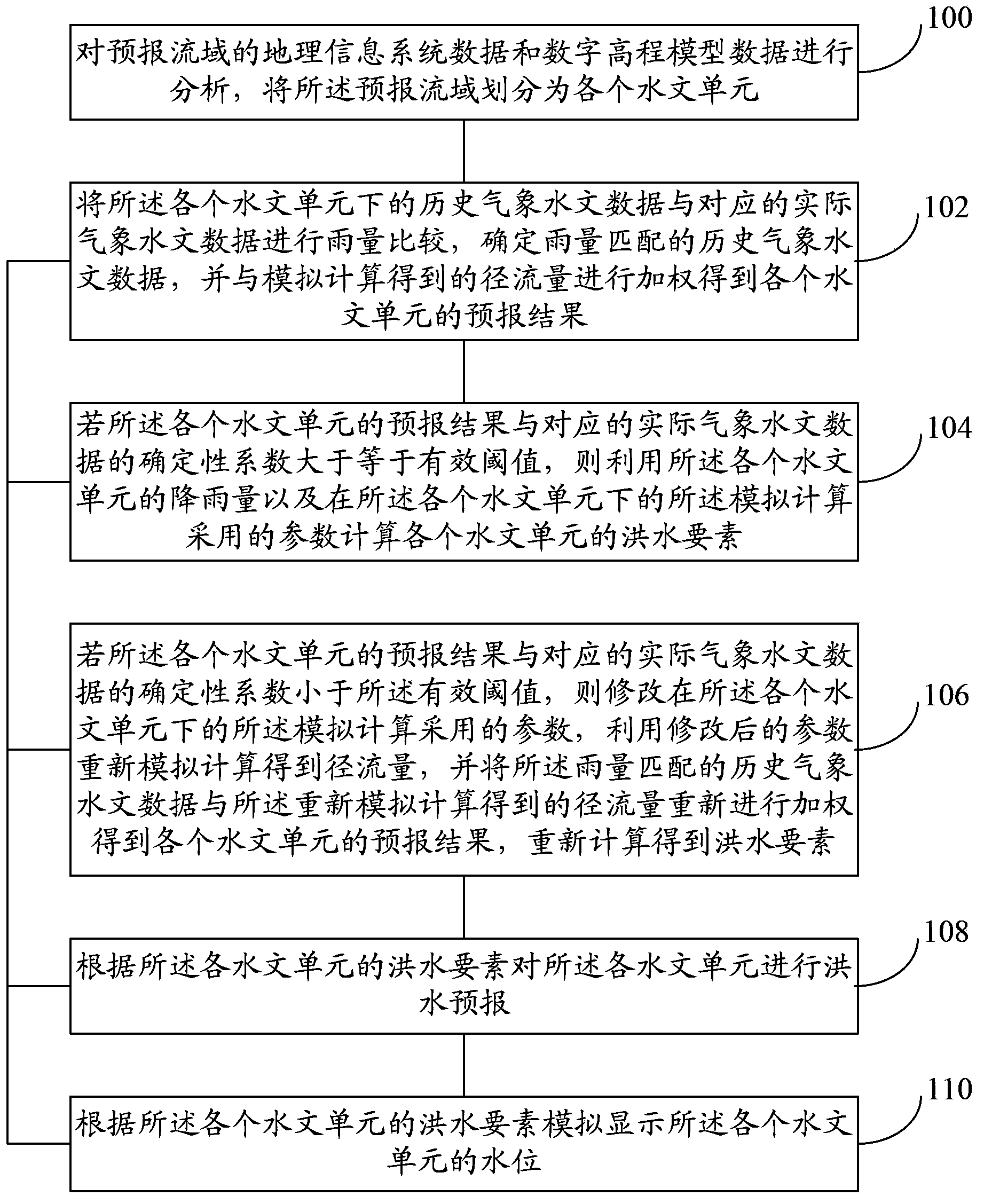
[0047] refer to figure 1 , shows a flow chart of a flood forecasting method based on historical data in an embodiment of the present invention.

[0048] Step 100, analyze the geographic information system data and digital elevation model data of the forecast watershed, and divide the forecast watershed into various hydrological units.

[0049] According to GIS data and Digital Elevation Model (Digital Elevation Model, DEM) data, using the starting latitude and longitude of the forecast watershed, the topological structure of each hydrological unit in the forecast watershed can be extracted. Then, the historical meteorological and hydrological data of the forecast basin are weighted and averaged according to the nodes in the topological structure of each hydrological unit to obtain the historical meteorological and hydrological data of each h...

Embodiment 2

[0073] A flood forecasting method based on historical data provided by an embodiment of the present invention is introduced in detail.

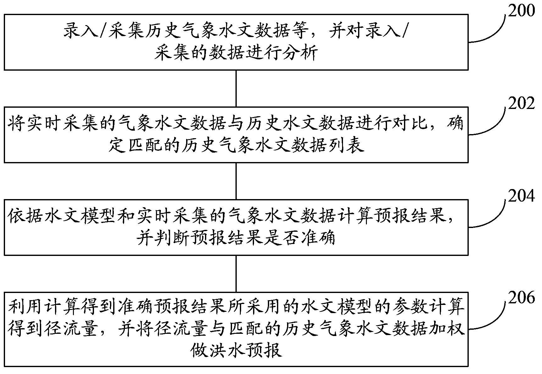
[0074] refer to figure 2 , shows a flow chart of a flood forecasting method based on historical data in an embodiment of the present invention.

[0075] Step 200, inputting / collecting historical meteorological and hydrological data, etc., and analyzing the entered / collected data.

[0076] The entered / acquired data may include GIS data, DEM data, meteorological data, hydrological data, flood event data, and remote sensing data.

[0077] Analyze the input / collected data to obtain the topological structure of the river network, the terrain of the underlying surface, the central zone of the storm, the relationship between rainfall and water level, and the relationship between rainfall and disasters.

[0078] Step 202, comparing the meteorological and hydrological data collected in real time with the historical hydrological data, and determinin...

Embodiment 3

[0086] A flood forecasting system based on historical data provided by the embodiment of the present invention is introduced in detail.

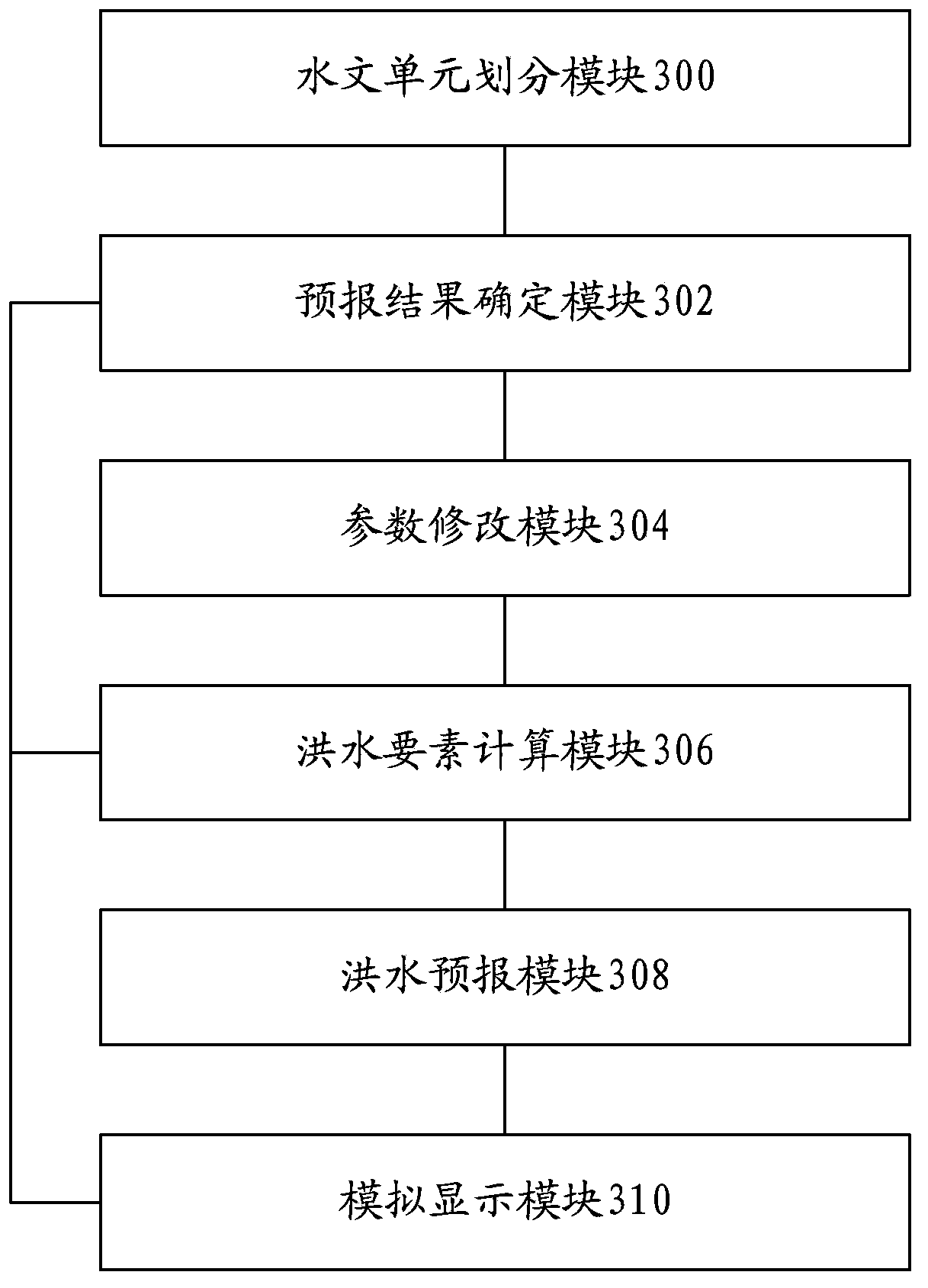
[0087] refer to image 3 , shows a structural diagram of a flood forecasting system based on historical data in an embodiment of the present invention.

[0088] The flood forecasting system based on historical data may include: a hydrological unit division module 300, a forecast result determination module 302, a parameter modification module 304, a flood element calculation module 306, a flood forecast module 308, and a simulation display module 310.

[0089] The functions of each module and the relationship between each module are introduced in detail below.

[0090] The hydrological unit division module 300 is configured to analyze the geographic information system data and digital elevation model data of the forecast watershed, and divide the forecast watershed into various hydrological units.

[0091] The forecast result determination...


PUM


Abstract

The embodiment of the invention discloses a flood forecasting method and system based on historical data to solve a problem of low flood forecasting precision and accuracy. The method comprises the following steps: analyzing the GIS (Geographic Information System) data and the DEM (Digital Elevation Model) data of a forecasting drainage basin, and dividing the forecasting drainage basin into various hydrologic units; carrying out rainfall comparison on historical meteorological hydrologic data under each hydrologic unit with corresponding practical meteorological hydrologic data, determining the historical meteorological hydrologic data matched with rainfall, and weighting with runoff volume obtained by analog computation to obtain a forecasting result of each hydrologic unit; if a certainty coefficient of the forecasting result of each hydrologic unit and the corresponding practical meteorological hydrologic data is greater than or equal to an effective threshold value, utilizing the rainfall capacity of each hydrologic unit and a parameter adopted by analog computation under each hydrologic unit to calculate the flood element of each hydrologic unit; and according to the flood element of each hydrologic unit, carrying out flood forecasting. Floor forecasting precision and accuracy can be improved.

Description

technical field [0001] Embodiments of the present invention relate to the technical field of hydrological models, in particular to a method and system for flood forecasting based on historical data. Background technique [0002] my country has a vast territory and numerous rivers. It is located on the east side of the Eurasian continent and spans three latitudes: high, middle and low latitudes. The characteristics of the monsoon are very significant. The seasonal distribution of precipitation is very uneven, and flood disasters occur frequently. According to statistics, in 2011 alone, 89.42 million people in 1,846 counties (cities, districts) and 16,000 townships (towns) in 31 provinces (autonomous regions and municipalities) across the country were affected by disasters, 519 people died, 121 people were missing, and 690,000 houses collapsed. During the period, 136 cities were flooded, and the total direct economic loss of flood disasters was about 130.1 billion yuan. [0...

Claims


Application Information

Patent Timeline
IPC IPC(8): G06F19/00
CPCY02A90/10
Inventor 桂发二
Owner 浙江贵仁信息科技股份有限公司
Why Eureka
Try Eureka