Merging method of membership scoring based on ground object categories under spatial-spectral combined classification frame for hyper-spectral remote sensing images

A hyperspectral remote sensing and space spectrum combination technology, which is applied in the field of space spectrum combination classification of hyperspectral remote sensing images, can solve problems such as the degree of diversity aggravated by multiple scattering effects, the phenomenon of different objects with the same spectrum, and the difficulty of classification, and achieve high-quality classification. effect, high classification accuracy, and the effect of ensuring the classification effect

Inactive Publication Date: 2015-03-04
FUDAN UNIV
View PDF4 Cites 7 Cited by
  • Summary
  • Abstract
  • Description
  • Claims
  • Application Information

AI Technical Summary

Problems solved by technology

In addition, factors such as low spatial resolution, heterogeneity of surface object distribution, and multiple scattering effects will aggravate the degree of diversity [...

Method used


Image

  • Merging method of membership scoring based on ground object categories under spatial-spectral combined classification frame for hyper-spectral remote sensing images
  • Merging method of membership scoring based on ground object categories under spatial-spectral combined classification frame for hyper-spectral remote sensing images
  • Merging method of membership scoring based on ground object categories under spatial-spectral combined classification frame for hyper-spectral remote sensing images

Examples


Embodiment Construction

[0047] Below, take actual remote sensing image data as an example to illustrate the specific embodiment of the present invention:

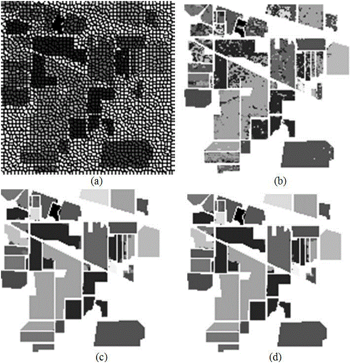
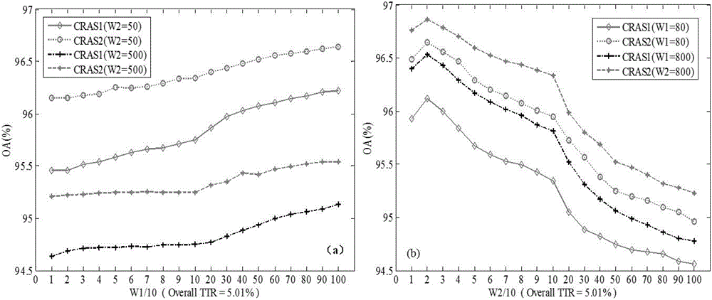
[0048] The merging method based on membership score in the present invention is denoted by CRAS, and the two modes of adopting natural neighborhood and extended neighborhood are denoted by CRAS1 and CRAS2 respectively. Combining the first two links in the "classification-segmentation-merging" framework, the present invention is represented by SVM / KNN+SLIC+CRAS1 / CRAS2.

[0049] real data experiment

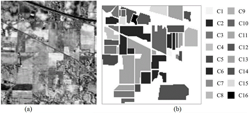
[0050] We test the performance of the proposed algorithm using an actual hyperspectral remote sensing image dataset. The data set is the Indian Pines data set taken in 1992 by the Airborne Visible / Infrared Imaging Spectrometer (AVIRIS). The dataset contains 145×145 pixels, 220 bands, the wavelength range is 0.4-2.5μm, and the spectral resolution is 10nm. After removing bands with low SNR or water absorption, the remaining 186 bands were used for alg...


PUM


Abstract

The invention belongs to the field of remote image processing technology, in particular to a merging method of membership scoring based on ground object categories under a spatial-spectral combined classification frame for hyper-spectral remote sensing images. In the method, a ground object classification mark graph with high precision is obtained finally in combination with a primary classification result based on spectral information and a primary partition result based on spatial information, and a new strategy is provided to the merging section of a classification, partition and merging frame. Three factors, including spatial consistency of hyper-spectral remote sensing images, spectral variability and transcendental knowledge are balanced synchronously by using the fuzzy theory as the basis and the membership scoring as the core, so that the classification precision can be improved effectively, and the spatial smoothness and the readability of the classification mark graph can be strengthened. Meanwhile, the merging method has good compatibility and robustness and can cope with many uncertainty factors such as low-precision primary classification, partition results and parameter variation; and the practicability of the spatial-spectral combined classification frame can be improved. The merging method has important application value in the classification of the hyper-spectral images.

Description

technical field [0001] The invention belongs to the technical field of remote sensing image processing, and in particular relates to a hyperspectral remote sensing image space-spectrum combination classification method. Background technique [0002] Remote sensing technology is a new comprehensive technology developed in the 1960s. It is closely related to science and technology such as space, electron optics, computer, and geography. It is one of the most powerful technical means for studying the earth's resources and environment. Hyperspectral remote sensing is a multi-dimensional information acquisition technology that combines imaging technology with spectral technology. The hyperspectral imager simultaneously detects the two-dimensional geometric space and one-dimensional spectral information of the target on dozens to hundreds of very narrow and continuous spectral segments of the electromagnetic spectrum, providing extremely rich information for the extraction and ana...

Claims


Application Information

Patent Timeline
IPC IPC(8): G06T7/00G06K9/66
CPCG06V20/194G06V20/13G06F18/2135G06F18/2411G06F18/24147
Inventor 陈昭王斌
Owner FUDAN UNIV
Why Eureka
Try Eureka