
Power line three-dimensional reconstructing method based on airborne laser radar point cloud

An airborne lidar and three-dimensional reconstruction technology, which is applied in 3D modeling, electromagnetic wave re-radiation, radio wave measurement system, etc., can solve the problems of poor robustness and universality, low degree of automation, and low reconstruction accuracy. Achieve the effects of good robustness and universality, high degree of automation, and high reconstruction accuracy

Inactive Publication Date: 2015-06-24
CHINESE ACAD OF SURVEYING & MAPPING
View PDF3 Cites 43 Cited by
  • Summary
  • Abstract
  • Description
  • Claims
  • Application Information

AI Technical Summary

Problems solved by technology

[0005] First, insufficient consideration is given to the three-dimensional space structure and layout of power lines
The power lines in the first gear of the high-voltage line can be arranged in various configurations such as triangular, horizontal, vertical, and mixed. However, the classic Hough transform method cannot detect multiple vertically arranged power lines; and, for multiple vertically arranged Power lines, due to the sag phenomenon, it is impossible to separate the lidar points of different power lines through the elevation value feature
[0006] Second, insufficient understanding of the types of power lines
For the split wire, since the spacer will connect each split, and the airborne lidar point cloud cannot distinguish the spacer lidar point and the power line lidar point in detail, this will cause some spatial clustering algorithms to cluster each split into a cluster , will cause errors in subsequent rebuilds
[0007] Third, insufficient utilization of information on tower poles
However, existing methods ignore the potential value of tower pole information in power line reconstruction
[0008] Fourth, insufficient robustness to gross errors
These gross errors have a significant impact on the accuracy of the fitting model based on classical least squares, while most existing power line extraction and reconstruction methods ignore the negative effects of gross errors, making the method less robust
[0009] Fifth, the 3D model of the power line used is complex and diverse, and some models have theoretical errors
For example, when some methods forcefully fit the parabolic formula in two-dimensional space to three-dimensional space, there are model errors, which will lead to reconstruction errors when applied to the power line fitting of real three-dimensional space.
[0010] The above problems lead to the existing three-dimensional reconstruction methods of power lines that require more parameters, low degree of automation, require a lot of manual intervention, poor robustness and universality, low reconstruction accuracy, etc. line patrol needs

Method used


Image

  • Power line three-dimensional reconstructing method based on airborne laser radar point cloud
  • Power line three-dimensional reconstructing method based on airborne laser radar point cloud
  • Power line three-dimensional reconstructing method based on airborne laser radar point cloud

Examples


Embodiment Construction

[0047] In order to clearly illustrate the technical features of this solution, the present invention will be described in detail below through specific implementation modes and in conjunction with the accompanying drawings. The following disclosure provides many different embodiments or examples for implementing different structures of the present invention. To simplify the disclosure of the present invention, components and arrangements of specific examples are described below. Furthermore, the present invention may repeat reference numerals and / or letters in different instances. This repetition is for the purpose of simplicity and clarity and does not in itself indicate a relationship between the various embodiments and / or arrangements discussed. It should be noted that components illustrated in the figures are not necessarily drawn to scale. Descriptions of well-known components and processing techniques and processes are omitted herein to avoid unnecessarily limiting the...


PUM


Abstract

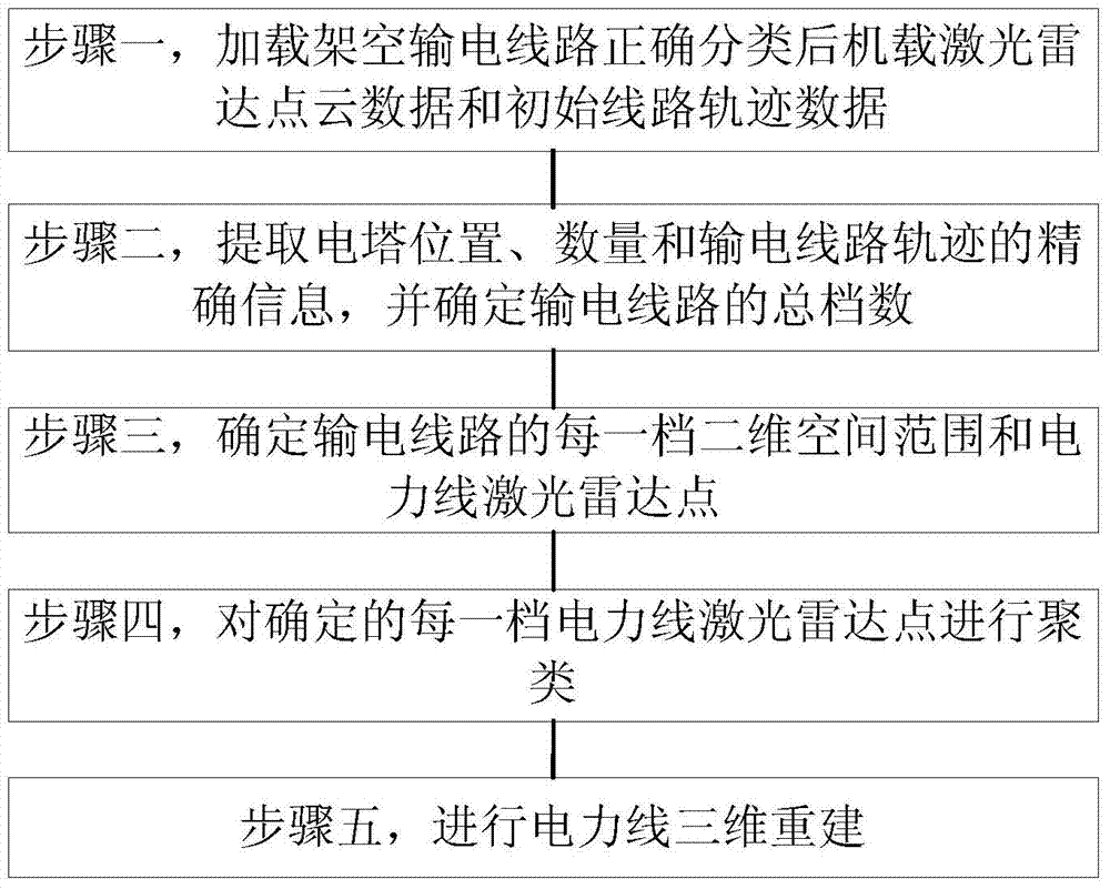
The invention discloses a power line three-dimensional reconstructing method based on airborne laser radar point cloud. Data of the airborne laser radar point cloud have been correctly classified. The method includes the following steps: 1, loading the correctly-classified data of the airborne laser radar point cloud and initial line track data of an overhead transmission line; 2, extracting accurate information of the positions and the number of electric towers and the track of the power transmission line, and determining the total number of spans of the power transmission line; 3, determining the two-dimensional space range and power line laser radar points of each span of the power transmission line; 4, clustering the determined power line laser radar points of the spans; 5, carrying out power line three-dimensional reconstruction. According to the power line three-dimensional reconstructing method, the number of required parameters is small, the automation degree is high, robustness and universality are better, and the power line three-dimensional reconstructing method has the advantage of being insensitive to the factors such as the number of power lines, the types of the power lines, the power line space arrangement structure, gross error points, point-cloud irregular breaking and the line length; in addition, a reconstruction model has the high reconstruction accuracy.

Description

technical field [0001] The invention relates to a method for three-dimensional reconstruction of power lines using airborne laser radar point clouds, specifically a method for three-dimensional reconstruction of power lines for long-distance overhead transmission lines based on airborne laser radar point cloud data, which belongs to laser radar point cloud data information Extract technology fields. Background technique [0002] Overhead transmission lines are an important national infrastructure. In order to prevent and eliminate the occurrence of power grid safety accidents, power line inspection is an important task for the power grid operation and maintenance management department. Manual line inspection has high labor intensity, difficult working conditions, low efficiency, long re-inspection cycle, and low accuracy of inspection data. [0003] In recent years, airborne lidar measurement technology has been increasingly widely used in helicopter power line inspection....

Claims


Application Information

Patent Timeline
Patent Type & Authority Applications(China)
IPC IPC(8): G06T17/30G01S17/88
Inventor 林祥国张继贤段敏燕臧艺
Owner CHINESE ACAD OF SURVEYING & MAPPING
Learn More