Farmland nutrient management partitioning method based on GIS and RS

A technology for managing zoning and nutrients, applied in the fields of precision agriculture and agricultural informatization, can solve problems such as poor practicability, inability to truly meet the requirements of precision, and large errors, so as to reduce unreasonable fertilizer input, reduce soil nutrient imbalance, and reduce agricultural The effect of production costs

Inactive Publication Date: 2015-08-12
SHIHEZI UNIVERSITY
View PDF0 Cites 7 Cited by
  • Summary
  • Abstract
  • Description
  • Claims
  • Application Information

AI Technical Summary

Problems solved by technology

[0006] The existing cropland management zoning technology still uses traditional soil nutrient data, and the data source is single, only soil nutrient data and geographic location data, and lacks remote sensing data closely related to cropland zoning
[0007] The existing cultivated land management zoning technology has a simple algorithm. In the process of nutrient interpolation analysis, a single interpolation analysis is generally used. The algorithm is single and the error is large, which seriously affects the accuracy of the analysis and cannot really meet the accuracy requirements of modern intelligent fertilization. less practical
[0008] ③ The selection of remote sensing data for the existing cultivated land management zones needs to be optimized, and the phenological periods of different crops are not consistent. According to the inconsistent phenological periods of different crops, remote sensing images of appropriate periods should be selected

Method used


Image

  • Farmland nutrient management partitioning method based on GIS and RS
  • Farmland nutrient management partitioning method based on GIS and RS
  • Farmland nutrient management partitioning method based on GIS and RS

Examples


Embodiment 1

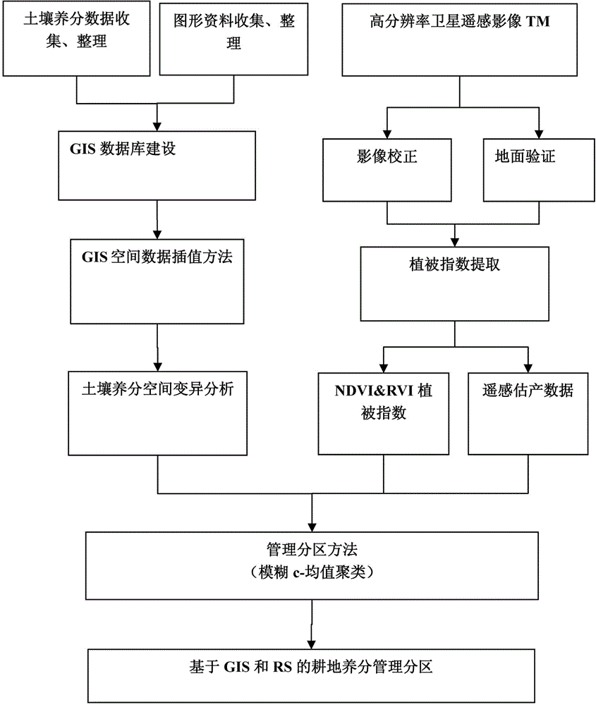
[0033] Such as figure 1 As shown, a GIS and RS-based zoning method for cultivated land nutrient management, specifically includes the following steps:

[0034] A method for zoning nutrient management of cultivated land based on GIS and RS, comprising the following steps:

[0035] Step 1: Determine the best time period for crop remote sensing yield estimation, obtain appropriate remote sensing image data, and use crop phenology calendar to select appropriate remote sensing image data according to the different growth rhythms of different crops;

[0036] Step 2: Use remote sensing image processing technology to obtain a suitable vegetation index: extract the remote sensing image data of different vegetation obtained in step 1 to obtain the vegetation index according to the image processing technology, and select the vegetation index related to the yield data;

[0037] Step 3: Obtain the GPS location information and soil nutrient data of the sample soil;

[0038] Step 4: Conver...

Embodiment 2

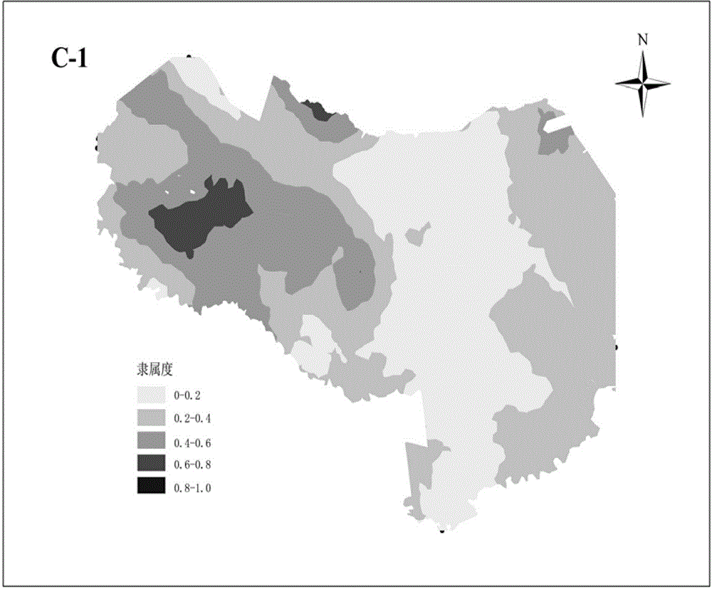
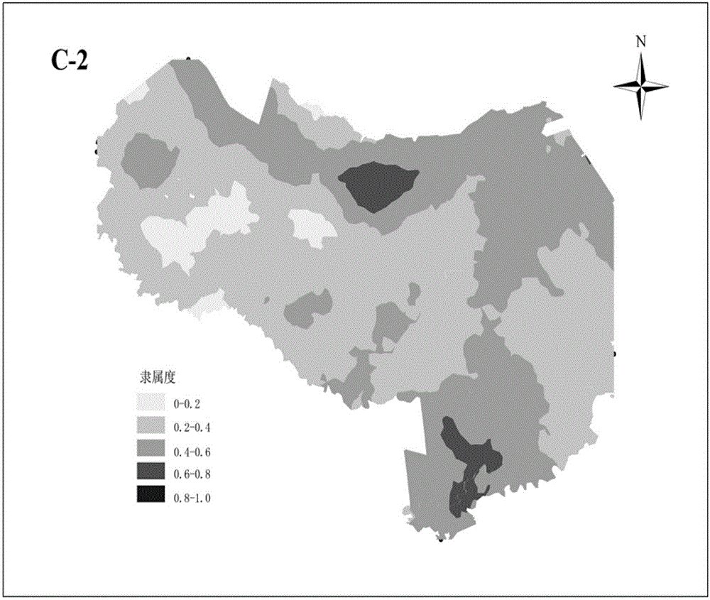
[0048] Step 1: According to the cotton growth phenology in the study area, the Landsat-5 TM image of the study area was used, the date of reception was September 13, 2011, a total of half views, the spatial resolution was 30m*30m, the track number was 146 / 29, including 7 band, the vegetation information is displayed better.

[0049] Step 2: Select a vegetation index that can reflect better crop growth: normalized difference vegetation NDVI and ratio vegetation index RVI, NDVI=TM4-TM3 / TM4-TM3, RVI=TM4 / TM3. This study completed the verification of ground yield measurement in the study area during 7 days from September 13 to 19, 2011. After statistical analysis, the geographical coordinates and cotton yield measurement data of 64 strip fields in the study area were obtained. A regression model was established between 44 yield data and vegetation index, and the remaining 22 yield data were used for model testing. Yield estimation data is mainly used for correlation analysis with so...


PUM


Abstract

The invention discloses a farmland nutrient management partitioning method based on a GIS and an RS. The method comprises determining the optimal phase for crop remote sensing yield estimation and obtaining remote sensing image data; obtaining an appropriate vegetation index by using remote sensing image processing technology; obtaining GPS position information and soil nutrient data of sampled soil; subjecting the collected cartographic information to cartographic scanning digitization and graph rectification; unifying the dimension and order of magnitude of the obtained vegetation index, the obtained GPS position information and soil nutrient data and information in a database to; conducting cluster analysis of the data after unifying of the dimension and order of magnitude, and displaying sampled soil property data in different categories and difference among data combination; and selecting an interpolation method through a geographic information system (GIS) by using spatial information contained in an output result of fuzzy clustering, and directly reflecting visual expression of a sampling point soil quantitative affiliation geospatially. The purposes of fine management of a farmland and rational fertilization are achieved.

Description

technical field [0001] The present invention relates to the fields of precision agriculture and agricultural informatization, in particular, a GIS and RS-based method for zoning nutrient management of cultivated land. Background technique [0002] Unreasonable fertilizer input leads to soil nutrient imbalance. Low fertilizer utilization not only increases agricultural production costs but also causes serious soil and river pollution. Therefore, it is a major practical problem for the sustainable development of China's agriculture to understand the nutrient status of regional farmland and to apply fertilizer in a balanced and reasonable manner. . Cultivated land management zoning is an important part of modern precision agricultural variable fertilization technology. Scientific, reasonable and practical management zoning division has important theoretical significance and practical value for variable input and precise management decision-making on soil and crops. [0003] Th...

Claims


Application Information

Patent Timeline
Patent Type & Authority Applications(China)
IPC IPC(8): G06Q10/04G06Q50/02G06T7/00
Inventor 吕新张泽吕宁陈剑李新伟王海江王飞
Owner SHIHEZI UNIVERSITY
Why Eureka
Try Eureka