Power network GIS based meteorology single-station radar early warning method and system

A GIS map and radar technology is applied in the field of meteorological single station radar early warning method and system based on power grid GIS, which can solve the problems of short judgment time, strong regional meteorological disasters, and inability to be associated with power grid systems, so as to reduce weather disasters. Influence, improve the level of safe operation, reduce the effect of waste of emergency resources

Inactive Publication Date: 2015-10-07
EMERGENCY MANAGEMENT CENT OF STATE GRID SHANDONG ELECTRIC POWER
View PDF4 Cites 9 Cited by
  • Summary
  • Abstract
  • Description
  • Claims
  • Application Information

AI Technical Summary

Problems solved by technology

However, meteorological disasters are highly regional, and the judgment time is short, and their strength, impact time, and impact range have different impacts on power grid equipment and operation.
Meteorological information, as independent information in the power grid system, is not combined with the power grid GIS platform system. Often only meteorological information is obtained, but it cannot be associated with the power grid system, and it is impossible to obtain timely and accurate information on the impact of meteorological disasters on power grid equipment and operation. So that the weather has no corresponding early warning effect on the power grid
[0004] The existing meteorological monitoring and early warning system lacks early warning analysis for single-station radar, and is not combined with power grid equipment or associated power grid operation. It cannot realize timely and effective early warning of disaster weather for power grid equipment, and cannot timely prepare the power grid before the catastrophic weather comes. Protection of equipment

Method used


Image

  • Power network GIS based meteorology single-station radar early warning method and system

Examples


Embodiment Construction

[0036] Below in conjunction with accompanying drawing and embodiment the present invention will be further described:

[0037] The system architecture of the present invention adopts the J2EE multi-layer architecture, which has good scalability, is convenient for system interconnection, has high security, and is also easy to maintain and manage. At the same time, the standard J2EE multi-layer system and component design are adopted to provide a reliable underlying foundation for the operation of the platform system, making the system development faster and more efficient, and the system's security, scalability, portability, usability, and ease of use. Maintainability is strongly guaranteed.

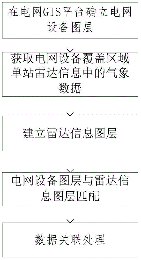
[0038] In the power grid GIS platform, the established standard specification meteorological data interface and data analysis specification are established, and the grid meteorological database is established; the established standard specification meteorological data interface includes t...


PUM


Abstract

The invention discloses a power network GIS based meteorology single-station radar early warning method and system. The method comprises the following steps: according to coordinates of power network equipment, determining a power network equipment layer; monitoring power network equipment disposed at specific latitudes and longitudes in real time, obtaining meteorology data in single-station radar information of a power network equipment coverage area; positioning meteorology data information to the power network GIS layer through latitude and longitude information of radar monitoring sites to establish a radar information layer; and establishing a single-station radar early-warning analysis model: performing data association processing on the power network equipment layer and the radar information layer in an early-warning area to determine meteorology early warning data of the power network equipment coverage area and displaying the meteorology early warning data on a power network GIS map. The method and system provided by the invention have the following advantages: a professional meteorological radar calamity early warning model is established, fine early warning of electric power facilities is realized, the destructiveness of calamities is reduced effectively, formation of relevant disaster prevention measures and standards is facilitated, and the loss of a power network is reduced.

Description

technical field [0001] The invention belongs to the field of meteorological early warning of electric power system, and in particular relates to a method and system of meteorological single-station radar early warning based on power grid GIS. Background technique [0002] Doppler weather radar is a kind of atmospheric detection equipment, which intermittently emits electromagnetic waves into the air, and propagates in the atmosphere with a path close to a straight line and a speed close to that of light waves. If a weather target is encountered, the pulsed electromagnetic wave will be scattered by the weather target. The radar echo intensity map is to project the distance, azimuth, echo intensity and other information of the rainfall target obtained by the weather radar from various azimuths to a planar map, which is effective data for monitoring cloud layers and rainfall systems. It plays an important role in monitoring, early warning, and forecasting heavy rainfall, storm...

Claims


Application Information

Patent Timeline
IPC IPC(8): G01W1/10G01S13/95
CPCG06F16/29G06Q50/06G01S13/95Y02A90/10
Inventor 李同智张治取孙世军王勇许乃媛杨啸帅韩洪王波张鹏程中华李景文汪友杰陈玉峰
Owner EMERGENCY MANAGEMENT CENT OF STATE GRID SHANDONG ELECTRIC POWER
Why Eureka
Try Eureka