Position estimation method based on integrated navigation of multiple sensors

A comprehensive navigation, multi-sensor technology, applied in position estimation based on DR/GPS/DME/VOR integrated navigation, high-precision, high-reliability positioning requirements of civil aircraft, can solve expensive inertial navigation systems, complex positioning methods, real-time Sexual issues, etc.

Active Publication Date: 2015-11-04
上海航空电子有限责任公司
View PDF4 Cites 14 Cited by
  • Summary
  • Abstract
  • Description
  • Claims
  • Application Information

AI Technical Summary

Problems solved by technology

[0005] The present invention proposes a position estimation based on multi-sensor integrated navigation in order to solve the problems that the existing civil aircraft integrated navigation and positioning method is complicated, the filter is easy to fail, the calculation amount is large, the real-time performance is poor, and an expensive inertial navigation system needs to be configured. method, using this method can provide high-precision, high-reliability position data for civil aircraft

Method used


Image

  • Position estimation method based on integrated navigation of multiple sensors
  • Position estimation method based on integrated navigation of multiple sensors
  • Position estimation method based on integrated navigation of multiple sensors

Examples


Embodiment 1

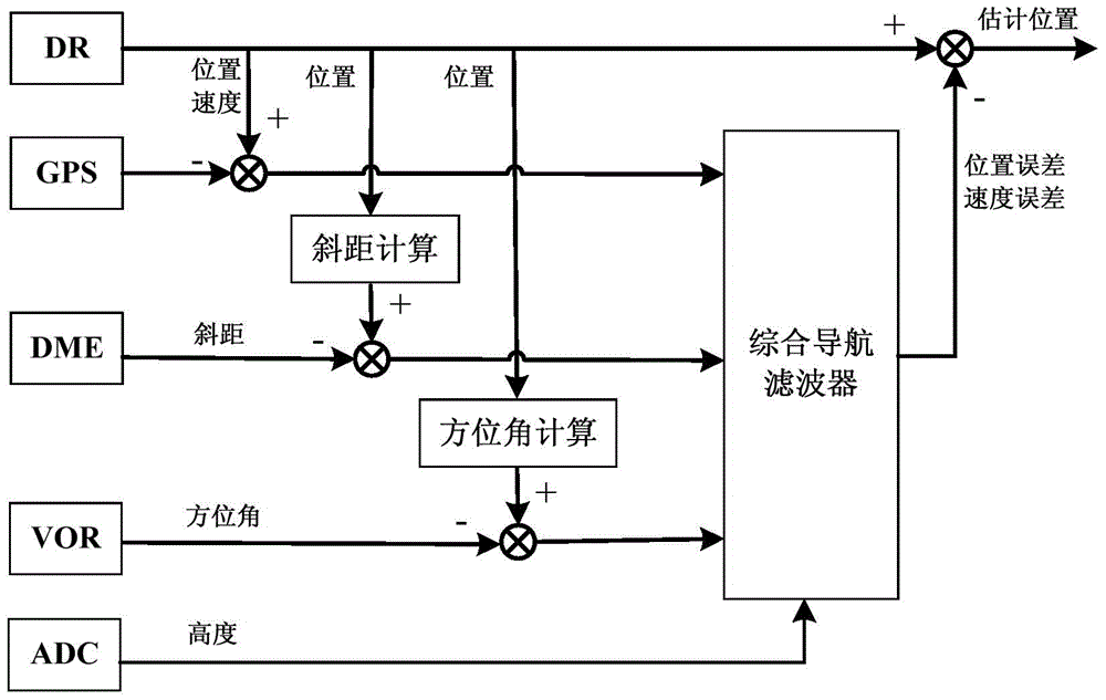
[0097] see figure 1 , the present invention fully utilizes the output parameter of existing DR, GPS, DME, VOR and ADC system under the premise of not using inertial navigation system, realizes the estimation of position information, comprises the following steps:

[0098] Step 1, collect the parameter that each navigation equipment output of airborne, described parameter comprises: (1) DR system output position, velocity information; (2) the position of GPS system output, velocity information; (3) the slant distance of DME system output Information; (4) Azimuth information output by the VOR system; (5) Altitude information output by the ADC system;

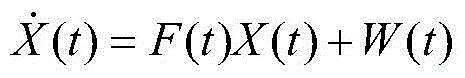
[0099] Step 2, establish the state equation of the integrated navigation system according to the height information output by the DR system error model and the ADC system;

[0100] X · ( t ) = F ( ...

Embodiment 2

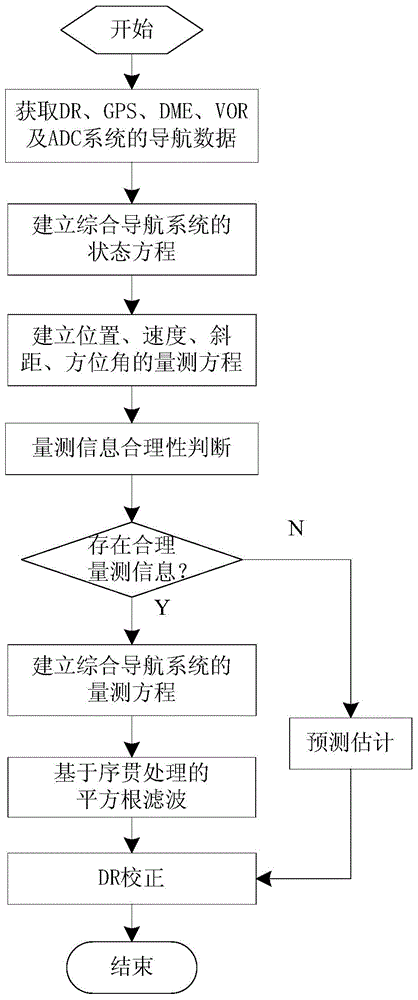
[0163] Such as figure 2 As shown, the present invention also proposes a solution for improving the first embodiment. In the second embodiment, the rationality of the measurement information is checked to realize the inspection and isolation of unreasonable information and avoid the introduction of unreasonable measurement information. In the filtering system, the stability and reliability of the system are improved; and different filtering methods are used for the two cases of reasonable and unreasonable measurement information, which effectively solves the problem of solving the problem of unreasonable measurement information. , to ensure the continuity of the position estimation data, the implementation steps of the second embodiment are as follows:

[0164] Steps 1-3 are the same as in Embodiment 1.

[0165] Step 4, using the measurement information rationality check method to sequentially perform position, speed measurement information (abbreviation: GPS measurement info...


PUM


Abstract

The invention discloses a position estimation method based on integrated navigation of multiple sensors. The method comprises the following steps: 1, parameters output by a DR, a GPS, a DME, a VOR and an ADC are acquired; 2, a state equation is established; 3, a position and velocity measurement equation of the GPS, a slope distance measurement equation of the DME and an azimuth measurement equation of the VOR are calculated; 4, a comprehensive measurement equation is established according to each measurement equation; 5, by combining the state equation and the comprehensive measurement equation, position error amount and velocity error amount are estimated; and 6, according to the estimated position error amount and velocity error amount, output correction is carried out on the DR system, and position estimation is finished. According to the invention, there is no need to use an inertial navigation system. The method provided by the invention has high positioning accuracy, high reliability and good real-time performance, is economic, effective and easy for engineering realization, and can meet high-precision and high-reliability positioning requirements of civil aircrafts.

Description

technical field [0001] The invention relates to a multi-sensor integrated navigation method, in particular to a position estimation method based on DR / GPS / DME / VOR integrated navigation, which is very suitable for high-precision and high-reliability positioning requirements of civil aircraft. Background technique [0002] For civil aircraft, safety always comes first. In order to ensure the flight safety of civil flights, large civil aircraft are generally equipped with multiple navigation systems. For example, the Airbus 320 is equipped with multiple navigation devices such as inertial navigation system, global positioning system (GPS), range finder (DME), VHF omnidirectional beacon (VOR), and dead reckoning (DR) for positioning. How to effectively and comprehensively utilize the information of multiple navigation devices for position calculation, so as to ensure the positioning accuracy and reliability of civil aircraft, is a key technology that needs to be solved urgently...

Claims


Application Information

Patent Timeline
Patent Type & Authority Applications(China)
IPC IPC(8): G01C21/20
CPCG01C21/20
Inventor 马航帅王丹孙晓敏熊智勇
Owner 上海航空电子有限责任公司
Why Eureka
Try Eureka