Levelling and calibrating method used for indoor space surveying and positioning system

A calibration method and positioning system technology, applied in the direction of measuring devices, instruments, etc., can solve the problems that the measurement site cannot meet the space requirements, affect the use of the measurement and positioning system, and have low efficiency, and achieve good practicability, high precision, and good stability. Effect

Inactive Publication Date: 2015-12-16
TIANJIN UNIV
View PDF5 Cites 11 Cited by
  • Summary
  • Abstract
  • Description
  • Claims
  • Application Information

AI Technical Summary

Problems solved by technology

[0004] However, on the one hand, in a complex environment, due to uncertainties such as space constraints and environmental interference, the measurement site cannot meet the calibration spa

Method used


Image

  • Levelling and calibrating method used for indoor space surveying and positioning system
  • Levelling and calibrating method used for indoor space surveying and positioning system

Examples


Embodiment Construction

[0023] In order to make the purpose, technical solution and advantages of the present invention clearer, the implementation manners of the present invention will be further described in detail below.

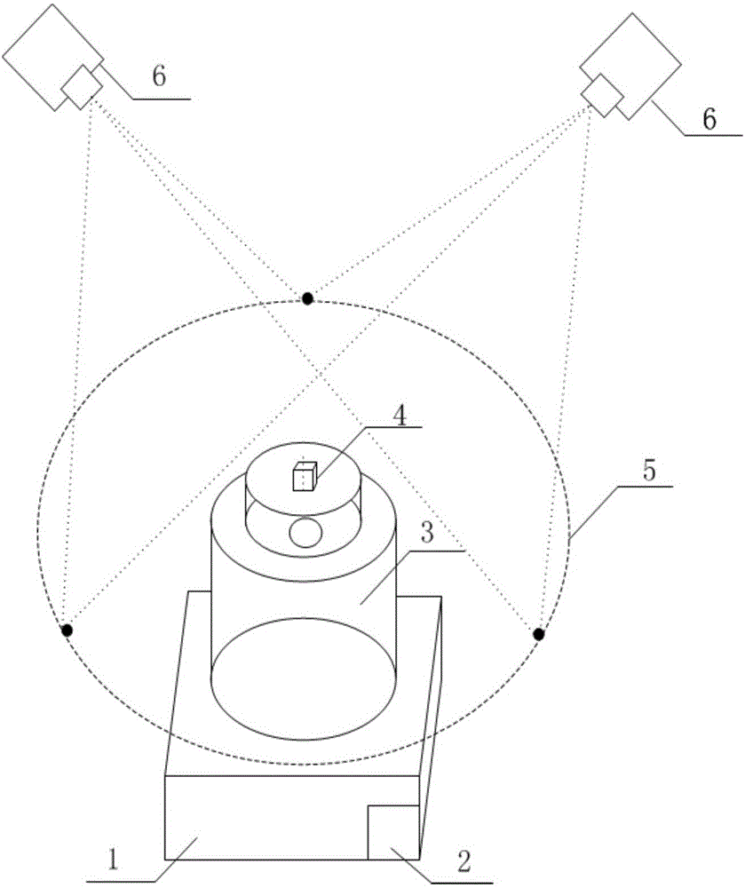
[0024] If the axis of rotation of the launch station can be precisely oriented and calibrated to a direction perpendicular to the horizontal plane, even if the XOY plane of the launch station coordinate system is parallel to the earth plane, then in the process of calibrating the external parameters of the launch station, only the launch station coordinate system needs to be oriented The rotation matrix R and translation matrix T between the coordinate systems of the two transmitting stations can be obtained, which greatly reduces the number of parameters to be calibrated and simplifies the process of external parameter calibration. Moreover, if the rotation axis is perpendicular to the earth, the rotation axis can also be used as a datum of the geodetic coordinate system, and th...


PUM


Abstract

The invention discloses a levelling and calibrating method used for an indoor space surveying and positioning system. The levelling and calibrating method comprises the following steps: rigidly connecting an inclinometer with a base; fixing a launch station at the top end of the base; fixing a laser at the top end of the launch station; supplying power by the launch station to drive the laser at the top end to emit visible laser to the outside, thus forming a scanning plane and guaranteeing that all points on the scanning plane are positioned inside a view field of a theodolite; reading the coordinate value in the Z-axis direction by utilizing three points which are aligned by the theodolite and are separated by 120 degrees; calculating the differences of three average values until any two difference value is smaller than 0.1mm, otherwise, adjusting the height of a support leg corresponding to the triangular base; and setting the output angle values of the two axes of the theodolite to be zero, and taking the output angle values as the levelling criterion of the launch station. According to the levelling and calibrating method, the calibration process of external parameters is simplified, and the applicability of the system is improved; a rotating shaft of the launch station is taken as the criterion of a geodetic coordinate system, and further, the position and posture relationship with other measuring instruments is established, so that the combined use of various instruments is convenient.

Description

technical field [0001] The invention relates to the field of three-dimensional coordinate precision measurement based on an indoor space measurement and positioning system (wMPS, workshopMeasurementPositioningSystem), in particular to a leveling and calibration method for an indoor space measurement and positioning system. Background technique [0002] The indoor space measurement and positioning system is a large-scale spatial coordinate networked high-precision automatic measurement system developed based on the principle of photoelectric scanning and angle intersection to meet the measurement requirements of large-scale manufacturing industries (such as aerospace and shipbuilding). The system draws on the measurement idea of ​​the global positioning system, uses multiple laser emitting devices (transmitting stations) to form a measurement network, locates a single receiver, and obtains the three-dimensional coordinates of the point where the receiver is located. The launc...

Claims


Application Information

Patent Timeline
IPC IPC(8): G01C25/00
CPCG01C25/00
Inventor 邾继贵任永杰杨凌辉林嘉睿史慎东
Owner TIANJIN UNIV
Why Eureka
Try Eureka