Eureka AIR delivers breakthrough ideas for toughest innovation challenges, trusted by R&D personnel around the world.

Vehicle positioning information system

A technology for positioning information and driving records, applied in the field of in-vehicle information systems, can solve the problems of inability to monitor the running situation in real time, occlusion of satellite signals, inaccurate positioning, etc., and achieve the effects of not easy to block, high positioning quality, and stable signals

Inactive Publication Date: 2016-03-09
TIANJIN FUWEI TECH DEV
View PDF3 Cites 0 Cited by
  • Summary
  • Abstract
  • Description
  • Claims
  • Application Information

AI Technical Summary

Problems solved by technology

[0002] The vehicle positioning information system is an interrelated information exchange system with the goal of determining the spatial position. Simply put, it is a satellite system composed of multiple satellites covering the whole world. Four satellites can be observed at any point at the same time to ensure that the satellite can collect the latitude, longitude and altitude of the observation point, so as to realize navigation, positioning, timing and other functions, and to guide the vehicle to accurately follow the selected route and arrive on time Destination; most of the existing vehicle positioning information systems use the GPS positioning system, but the GPS is in an urban area full of tall buildings, and the satellite signals are easily blocked, resulting in inaccurate positioning, and the existing vehicle positioning information systems cannot monitor their own location in real time. Operational conditions, there are often errors in navigation deviation

Method used


Image

  • Vehicle positioning information system

Examples


Embodiment Construction

[0017] It should be noted that, in the case of no conflict, the embodiments of the present invention and the features in the embodiments can be combined with each other.

[0018] In the description of the present invention, it should be noted that unless otherwise specified and limited, the terms "installation", "connection" and "connection" should be understood in a broad sense, for example, it can be a fixed connection or a detachable connection. Connected, or integrally connected; it may be mechanically connected or electrically connected; it may be directly connected or indirectly connected through an intermediary, and it may be the internal communication of two components. Those of ordinary skill in the art can understand the specific meanings of the above terms in the present invention based on specific situations.

[0019] The present invention will be described in detail below with reference to the accompanying drawings and examples.

[0020] Such as figure 1 As show...


PUM


Abstract

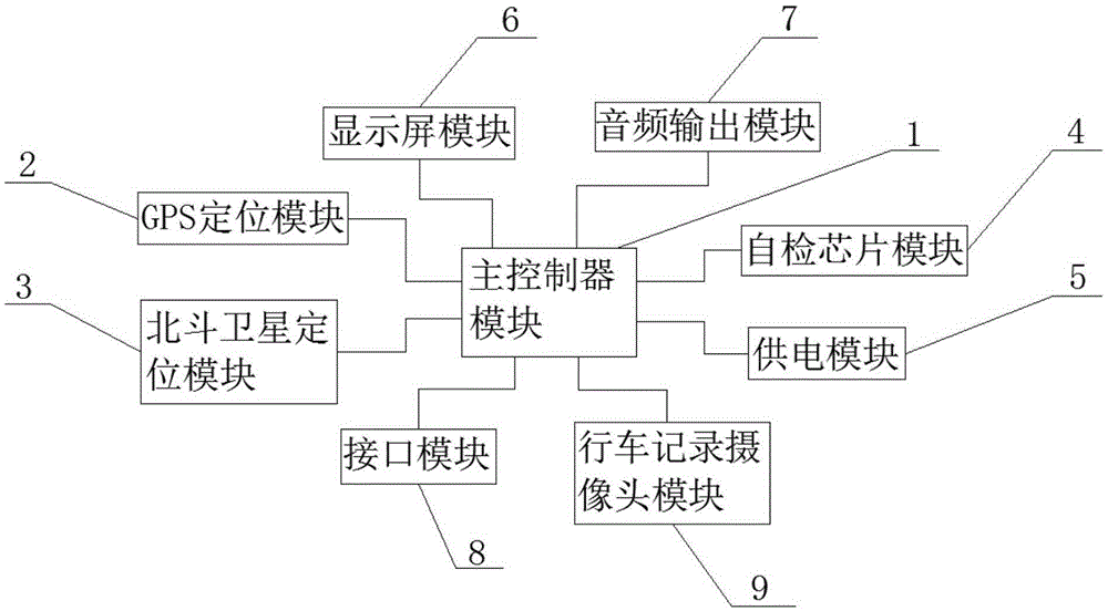
The invention provides a vehicle positioning system information, which comprises a main controller module, a GPS positioning module, a Beidou satellite positioning module, a self-test chip module, a power supply module, a display screen module, an audio output module, an interface module and a driving record camera module. The GPS positioning module and the Beidou satellite positioning module are connected to a data interface of the main controller module. A control interface of the main controller module is connected with the display screen module and the audio output module. The self-test chip module is connected with the main controller module. The power supply module is connected to a power supply interface of the main controller module. An interface module is further disposed on the main controller module. The driving record camera module is connected to the main controller module. The beneficial effects of the invention are that the vehicle positioning information system can combine GPS positioning and Beidou satellite positioning, is accurate in positioning, with continuous satellite positioning signals, can perform self-test and is accurate in navigation.

Description

technical field [0001] The invention belongs to the field of vehicle information systems, in particular to a vehicle positioning information system. Background technique [0002] The vehicle positioning information system is an interrelated information exchange system with the goal of determining the spatial position. Simply put, it is a satellite system composed of multiple satellites covering the whole world. Four satellites can be observed at any point at the same time to ensure that the satellite can collect the latitude, longitude and altitude of the observation point, so as to realize navigation, positioning, timing and other functions, and to guide the vehicle to accurately follow the selected route and arrive on time Destination; most of the existing vehicle positioning information systems use the GPS positioning system, but the GPS is in an urban area full of tall buildings, and the satellite signals are easily blocked, resulting in inaccurate positioning, and the e...

Claims


Application Information

Patent Timeline
Patent Type & Authority Applications(China)
IPC IPC(8): G01S19/48G01S19/33H04N5/76
CPCG01S19/48G01S19/33H04N5/76
Inventor 杨宏勇
Owner TIANJIN FUWEI TECH DEV
Why Eureka
Eureka Blog
Learn More