

Method for predicting whether longitude and latitude information of community is abnormal
A longitude and latitude, abnormal technology, applied in special data processing applications, instruments, electrical digital data processing, etc., can solve the problems of manual maintenance, accuracy cannot be evaluated, and low accuracy, so as to improve work efficiency, reduce human resource investment, Accuracy-promoting effect
- Summary
- Abstract
- Description
- Claims
- Application Information
AI Technical Summary
Problems solved by technology
Method used
Image

Examples
Embodiment 1
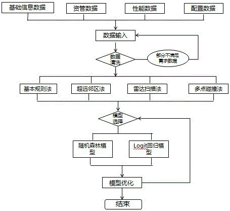
[0019] The method for predicting whether the latitude and longitude of a cell is abnormal according to this embodiment is based on the big data analysis service of the cloud platform, which automatically collects and cleans the data, and then excavates abnormal cells through qualitative analysis, and builds a model on this basis Concentrate on mining areas with suspected abnormal latitude and longitude; figure 1 Is the flow chart of the method for predicting whether the latitude and longitude of the cell is abnormal, as attached figure 1 Shown: Among them, the collected data includes basic information data, asset management data, performance data, and configuration data; the qualitative analysis methods used mainly include basic rule method, ultra-distant neighboring area method, radar scanning method and multi-point collision method ; Through the establishment of a random forest or LOGIT model, batches of areas with suspected abnormal latitude and longitude are excavated in ba...
PUM
 Abstract
Description
Claims
Application Information