Atmospheric correction method during INSAR measurement

An atmospheric correction and atmospheric delay technology, applied in the field of remote sensing, can solve the problems of time deviation, inaccurate water vapor content, inconvenience, etc., and achieve the effect of accurate atmospheric delay phase and reliable results

Inactive Publication Date: 2016-08-10
中科卫星应用德清研究院 +1
View PDF1 Cites 15 Cited by
  • Summary
  • Abstract
  • Description
  • Claims
  • Application Information

AI Technical Summary

Problems solved by technology

[0012] 1. The water vapor content data obtained by MERIS is affected by clouds, so in cloudy areas, the water vapor content of the data is not accurate
[0013] 2. This method is limited by the time resolution of MERIS data, the data receiving time is fixed, and the data time and the actual interferogram time will deviate, which will affect the calculation results
[0014] It can be seen that the above-mentioned existing atmospheric correction method obviously still has inconvenience and defects, and needs to be further improved urgently.

Method used


Image

  • Atmospheric correction method during INSAR measurement
  • Atmospheric correction method during INSAR measurement
  • Atmospheric correction method during INSAR measurement

Examples


Embodiment Construction

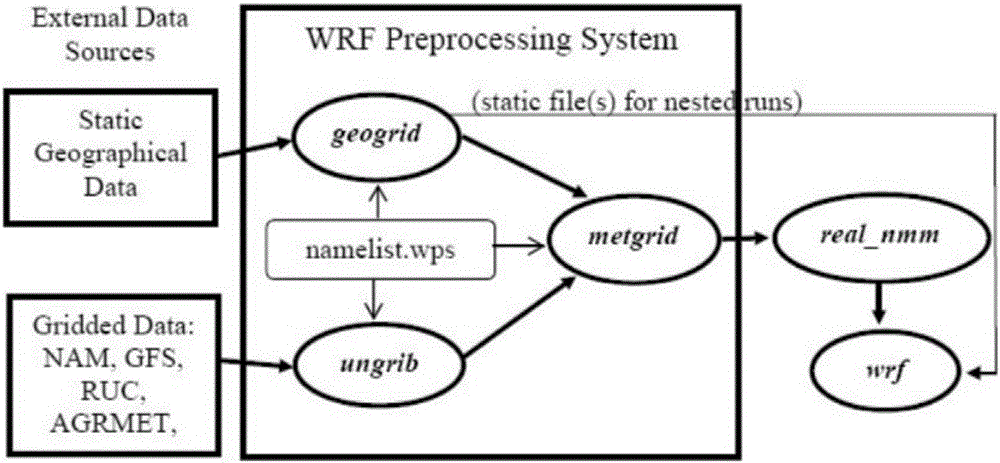
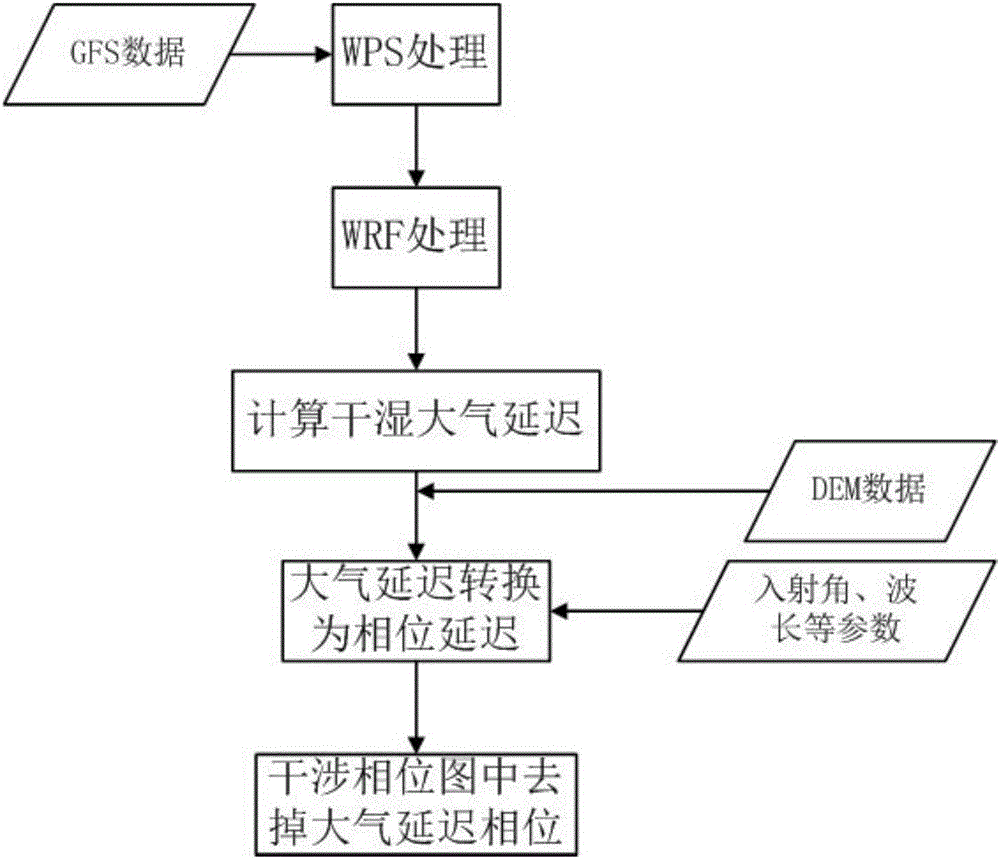
[0027] Such as figure 2 As shown, for the atmospheric correction in the INSAR measurement, the present invention mainly uses the WRF model to simulate the temperature, humidity, air pressure, and potential height required for calculating the atmospheric delay; use these atmospheric parameters to calculate the atmospheric dry and wet delay.

[0028] The WRF (Weather Research Forecast) model system is a new generation of mesoscale forecast model and assimilation system jointly developed and researched by scientists from many American research departments and universities. It is a flexible and perfect atmospheric simulation system, which is easy to carry, efficient, and The characteristics of parallel computing are widely used from meters to thousands of kilometers. Including: real-time numerical weather prediction, forecast research, parameterization research, etc. WRF model supports multiple meteorological data, and the meteorological data that the present invention adopts is...


PUM


Abstract

The invention discloses an atmospheric correction method during INSAR measurement. The method comprises the following steps of (1) using a WRF model to simulate a parameter needed during calculation of atmospheric delay, wherein the WRF model adopts GFS data as meteorological data; (2) calculating dry and wet atmospheric delay; (3) converting the atmospheric delay into phase delay; and (4) removing an atmospheric delay phase in an INSAR interference phase diagram. In the method, a mesoscale atmospheric model WRF is used to carry out atmospheric correction and the model can predict a weather condition and can reach a 1km resolution level, which is better than a prediction condition through using a method based on MERIS, MODIS and GPS data. By using the GFS meteorological data, a prediction data time interval is 3 hours and the data is updated for every 6b hours so that timeliness is high. A measurement result is accurate and the method is suitable for popularization and application.

Description

technical field [0001] The invention relates to the technical field of remote sensing, in particular to an atmospheric correction method in INSAR (Interferometric SAR, Synthetic Aperture Radar Interferometry) measurement. Background technique [0002] Atmospheric delay is one of the most important factors affecting the interferometric phase accuracy. Generally, the flight altitude of polar-orbiting SAR satellites is generally 500-800km. SAR electromagnetic wave propagation needs to pass through the ionosphere (the air layer from about 80km to 85-800km above the earth's surface) and the troposphere (the air layer from the earth's surface to 7-12km), thus being affected by the ionosphere. and tropospheric effects. In the ionosphere, the propagation of electromagnetic waves is delayed mainly due to the scattering effect of the ionized atmosphere; at the same time, due to changes in the total electron content (TEC) of the ionosphere, the propagation path of electromagnetic wave...

Claims


Application Information

Patent Timeline
Patent Type & Authority Applications(China)
IPC IPC(8): G01S13/90
CPCG01S13/9023
Inventor 原君娜谢酬邵芸
Owner 中科卫星应用德清研究院
Why Eureka
Try Eureka