Linear engineering three-dimensional geological modeling method

A technology of three-dimensional geology and modeling methods, applied in the field of geological modeling, can solve the problems of being unable to meet the needs of large-scale engineering applications, and the workload of manual interaction is large, so that the workload of human-computer interaction is small and the workload of large-scale applications can be satisfied Requirements, Effects of Rapid Refactoring

Active Publication Date: 2016-09-21
铁三院(天津)工程有限公司
View PDF4 Cites 7 Cited by
  • Summary
  • Abstract
  • Description
  • Claims
  • Application Information

AI Technical Summary

Problems solved by technology

Most of the existing 3D geological modeling commercial software is aimed at industries such as oil reservoirs and mines, and few are aimed at the characteristics of linear engineering, and the workload of manual interaction is relatively large, which cannot meet the needs of large-scale engineering applications

Method used


Image

  • Linear engineering three-dimensional geological modeling method
  • Linear engineering three-dimensional geological modeling method

Examples


Embodiment Construction

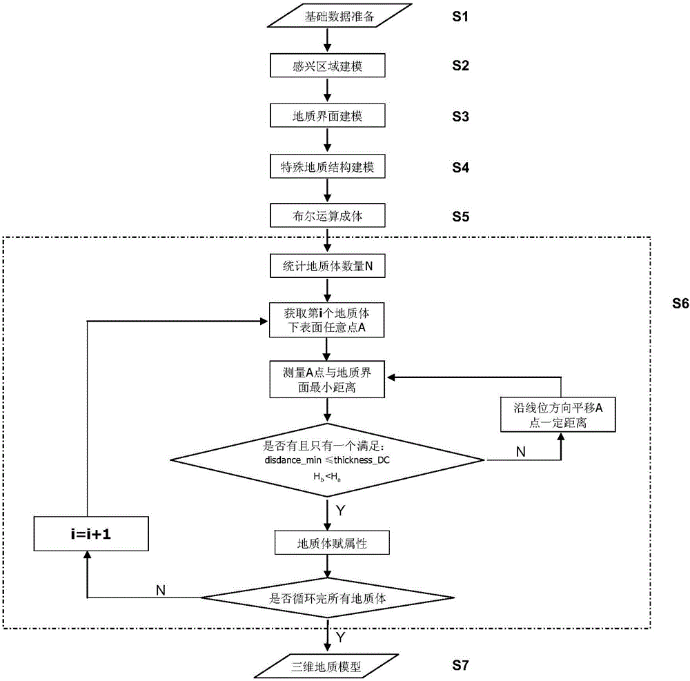
[0028] In order to further understand the invention content, characteristics and effects of the present invention, the following examples are given, and detailed descriptions are as follows in conjunction with the accompanying drawings:

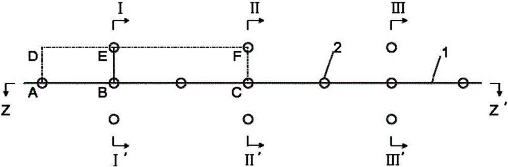
[0029] see figure 1 and figure 2 , a linear engineering three-dimensional geological modeling method, comprising the following steps:

[0030] S1: basic data preparation;

[0031] Geological interface lines can be obtained by electronic longitudinal (transverse) sections, engineering geological plane maps, engineering geological data backup databases, digital paper sections, and other methods. Each stratum boundary line is composed of data points, including the three-dimensional coordinates (x, y, z) of the data points, and the topological attribute information of the data line (stratum attribute information: layer number, geological age, geological origin, stratum name, weathering degree, etc.).

[0032] In addition, the topographic surf...


PUM


Abstract

The invention discloses a linear engineering three-dimensional geological modeling method. Three-dimensional geological modeling methods and technologies are immature due to engineering geological condition complexity and cognition limitation. Present three-dimensional geological modeling business software is mainly for the industries such as oil reservoirs and mines, and is seldom based on linear engineering characteristics; in addition, the workload of man-machine interaction is greater and can not meet large scale engineering application requirements. Based on the characteristics of linear engineering prospective design, the method mainly involves a vertical section segment, a horizontal-vertical section segment and a special geological structure (a fault, etc), and includes first setting an interest region entity, establishing a geological interface model, and diving into geologic bodies through Boolean operation, thereby avoiding possible topological problems by employing surface closed body formation; besides, the model is an entity, is in favor of late stage simulation, design and engineering workload calculation, has the characteristics of small man-machine interaction workload and strong model controllability, and can meet large scale application demands.

Description

technical field [0001] The invention relates to the technical field of geological modeling, in particular to a three-dimensional geological modeling method for linear engineering. Background technique [0002] Three-dimensional geological modeling is a technology that uses computer technology to combine geological information with visualization tools in a three-dimensional environment for geological research. For 3D geological modeling, 3D geological models can be constructed by using modeling methods based on discrete formation points in boreholes, modeling methods based on geological sections, and modeling methods based on layer point clouds. However, in terms of engineering application, it is restricted to a certain extent, mainly as follows: [0003] On the one hand, the complexity of engineering geological conditions and the limitation of cognition. Geological bodies form extremely complex geometric forms and topological relationships in the process of construction ev...

Claims


Application Information

Patent Timeline
Patent Type & Authority Applications(China)
IPC IPC(8): G06T17/05
CPCG06T17/05
Inventor 李红旭张利国陈则连张晨张戎垦
Owner 铁三院(天津)工程有限公司
Why Eureka
Try Eureka