Hybrid location method and device based on V2X and GNSS

A hybrid positioning and location information technology, applied in the field of satellite positioning, can solve the problems of high speed requirements of mobile communication networks, costing communication costs, etc., and achieve the effect of saving positioning time and traffic costs, improving positioning performance, and increasing speed.

Inactive Publication Date: 2016-09-28
LEAUTO INTELLIGENT TECH (BEIJING) CO LTD
View PDF4 Cites 6 Cited by
  • Summary
  • Abstract
  • Description
  • Claims
  • Application Information

AI Technical Summary

Problems solved by technology

[0011] Embodiments of the present invention provide a hybrid positioning method and device based on V2X and GNSS to solve the problem of downloa

Method used


Image

  • Hybrid location method and device based on V2X and GNSS
  • Hybrid location method and device based on V2X and GNSS
  • Hybrid location method and device based on V2X and GNSS

Examples


Example Embodiment

[0035] Example one

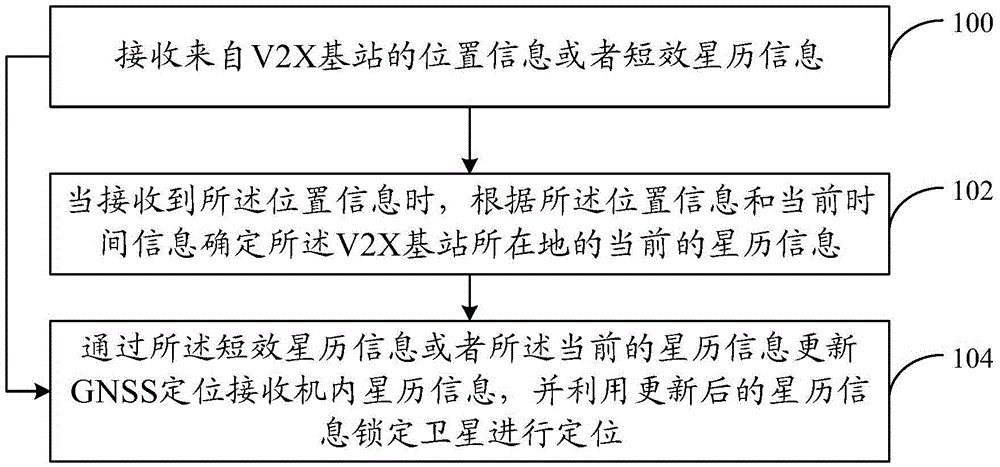
[0036] A hybrid positioning method based on V2X and GNSS proposed in the first embodiment of the present invention is introduced in detail. The hybrid positioning method based on V2X and GNSS in the first embodiment of the present invention can be applied to a positioning device that determines ephemeris information through V2X technology and is equipped on a vehicle for vehicle positioning.

[0037] Reference figure 1 , Shows a step flow chart of a hybrid positioning method based on V2X and GNSS in the first embodiment of the present invention.

[0038] Step 100: Receive position information or short-term ephemeris information from a V2X base station.

[0039] Since the V2X base station belongs to the road infrastructure and the physical location is stable, the V2X base station can pre-store its own location information and can also configure short-term ephemeris information. In the embodiment of the present invention, the V2X base station may be used as an auxi...

Example Embodiment

[0054] Example two

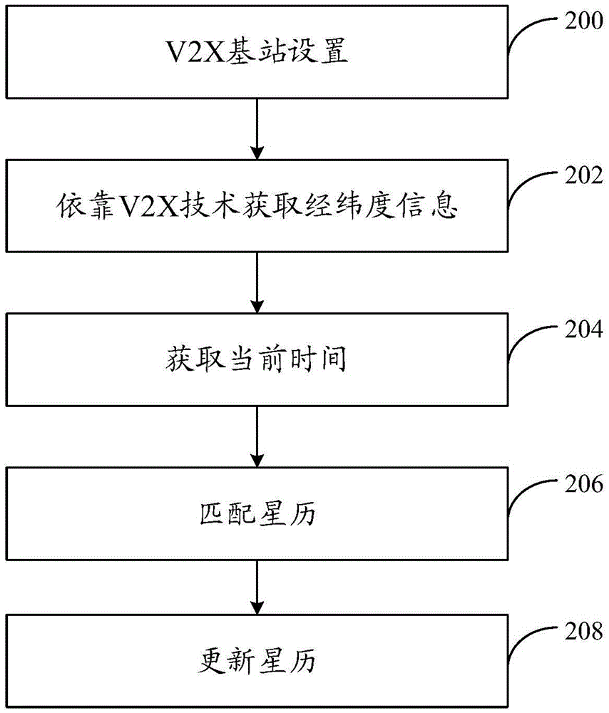
[0055] A hybrid positioning method based on V2X and GNSS proposed in the second embodiment of the present invention is introduced in detail. The hybrid positioning method based on V2X and GNSS in the second embodiment of the present invention can be applied to a positioning system that determines ephemeris information through V2X technology, including a positioning device and a V2X base station, and the positioning device is equipped on a vehicle Used for vehicle positioning.

[0056] Reference figure 2 , Shows a step flow chart of a hybrid positioning method based on V2X and GNSS in the second embodiment of the present invention.

[0057] Step 200, V2X base station settings.

[0058] Install V2X base stations in roads and parking lots. The communication protocol of the base stations is 802.11p. Within the area covered by each V2X base station, the V2X base station can communicate with the GNSS positioning receiver in both directions and transmit data. For the...

Example Embodiment

[0069] Example three

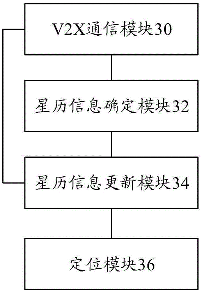
[0070] A hybrid positioning device based on V2X and GNSS proposed in the third embodiment of the present invention is introduced in detail.

[0071] Reference image 3 , Shows a schematic structural diagram of a hybrid positioning device based on V2X and GNSS in the third embodiment of the present invention.

[0072] The device may include: a V2X communication module 30, an ephemeris information determination module 32, an ephemeris information update module 34, and a positioning module 36. Among them, the V2X communication module 30 may be a communication chip in a positioning device that uses V2X technology to communicate with a V2X base station, and is an external communication component of the positioning device; the ephemeris information determining module 32 and the ephemeris information updating module 34 may be respectively positioning The two controllers of the device, the two controllers can respectively write corresponding algorithms to realize the ...


PUM


Abstract

Embodiments of the present invention provide a hybrid positioning method and device based on V2X and GNSS, wherein the method includes receiving position information or short-term ephemeris information from a V2X base station; when receiving position information, according to position information and current The time information determines the current ephemeris information of the location of the V2X base station; the ephemeris information in the GNSS positioning receiver is updated through the current ephemeris information, and the updated ephemeris information is used to lock the satellite for positioning; when the short-term ephemeris information is received , update the ephemeris information in the GNSS positioning receiver with the short-term ephemeris information, and use the updated ephemeris information to lock the satellite for positioning. The combination of V2X technology and GNSS technology is applied to the wireless positioning scene of mobile vehicles, which improves the speed of updating short-term ephemeris, and does not rely on mobile communication networks and large and complex ephemeris algorithms, saving positioning time and traffic cost, improving localization performance.

Description

Technical field [0001] The embodiments of the present invention relate to the technical field of satellite positioning, and in particular to a hybrid positioning method and device based on vehicle to outside information interaction (Vehicle to X, V2X) and GNSS. Background technique [0002] Global Navigation Satellite System (Global Navigation Statellite System, GNSS) refers to all satellite navigation systems, including global, regional and enhanced. The current GNSS includes the United States' Global Positioning System (GPS), Russia's Glonass (Russian GNSS abbreviation Glonass), Europe's Galileo (Galileo) and China's Beidou satellite navigation system. The Beidou satellite navigation system is a satellite navigation system with independent intellectual property rights in my country. It has the characteristics of two-way communication and therefore has obvious development advantages. [0003] The working principles of different GNSS are basically the same. To put it simply, any ...

Claims


Application Information

Patent Timeline
IPC IPC(8): G01S19/48G01S19/33
CPCG01S19/05G01S19/25G01S19/258G01S19/27G01S19/48G01S19/33
Inventor 徐勇林伟刘鹏李文锐陈昆盛
Owner LEAUTO INTELLIGENT TECH (BEIJING) CO LTD
Why Eureka
Try Eureka