Two-axis pod system based on geographic coordinate system pointing control

A geographic coordinate system, pointing control technology, used in control/regulation systems, attitude control, non-electric variable control and other directions

Active Publication Date: 2016-10-12
北京宇鹰科技有限公司
View PDF5 Cites 8 Cited by
  • Summary
  • Abstract
  • Description
  • Claims
  • Application Information

AI Technical Summary

Problems solved by technology

[0006] The technical problem of the present invention is: to overcome the deficiencies of the existing two-axis pod platform system, and propose a two-axis pod system based on the pointing control of the geographic coordinate system. By installing an autopilot parall

Method used


Image

  • Two-axis pod system based on geographic coordinate system pointing control
  • Two-axis pod system based on geographic coordinate system pointing control
  • Two-axis pod system based on geographic coordinate system pointing control

Examples


Embodiment Construction

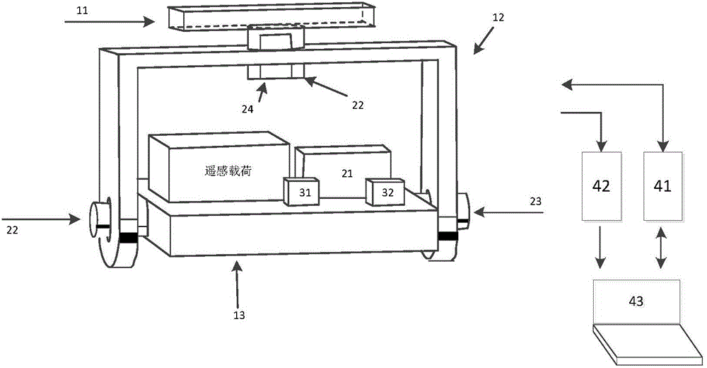
[0027] Such as figure 1 As shown, the present invention mainly comprises two-axis pod structure system (1), measurement and control unit (2), transmission system (3) and ground monitoring station (4), measurement and control unit (2) and transmission system (3) installation and two On the shaft pod structure system (1);

[0028] The two-axis pod structure system (1) is composed of a base plate (11), an azimuth frame (12) and a pitch frame (13). It is connected between the two-axis pod system and the moving carrier to isolate the non-ideal high-frequency motion interference of the moving carrier. The azimuth frame (12) is used as the outermost ring of the two-axis pod system to carry the pitch frame system to realize the two-axis pod system. The rotation of the azimuth direction of the system further affects the deflection of the visual axis of the remote sensing load in the azimuth direction under the geographical coordinate system. The rotation of the pod system in the pitc...


PUM


Abstract

The invention relates to a two-axis pod system based on geographic coordinate system pointing control. The two-axis pod system comprises a two-axis pod structure system, a measuring and control unit, a transmission system and a ground monitoring station, wherein the two-axis pod structure system is composed of a base plate, an azimuth frame and a pitching frame and is used for bearing a high-precision automatic driverscope and remote-sensing load; the measuring and control unit is composed of the high-precision automatic driverscope, a coded disc, a pitching motor and drive board and an azimuth motor and drive board and realizes measurement and control of a remote-sensing load visual shaft under a geographic coordinate; the transmission system is composed of a data transfer radio station and an image transfer radio station and realizes the real-time transfer of two-axis pod system data and remote-sensing load images; the ground monitoring station is composed of a data transfer receiver, an image transfer receiver and a ground display terminal, displays the angular information of the remote-sensing load of the two-axis pod system under a geographical coordinate system in real time and transmits a control command to the two-axis pod system according to task demands. According to the two-axis pod system provided by the invention, direct control is performed based on the pointing information of the remote-sensing load visual shaft under the geographical coordinate, so that the control precision of the two-axis pod system in an more-disturbing environment is ensured; the two-axis pod system is low in cost and convenient to apply and has important engineering values.

Description

technical field [0001] The invention relates to a two-axis pod system based on pointing control of a geographical coordinate system, which can be used for high-resolution remote sensing shooting of many types of unmanned aerial vehicles and manned machines, and is especially suitable for power line inspections with large-scale multi-target inspection requirements, Land resources surveying and mapping. Background technique [0002] The two-axis pod system has the advantages of small size, low cost, and flexible maneuverability. It can isolate the impact of the non-ideal attitude interference of the moving carrier on the load boresight, and realize the precise positioning and shooting of ground objects. It is used in military, civilian, and scientific research. The prospects are very broad. [0003] The high-resolution remote sensing payload requires the moving carrier to move at a uniform and stable ideal during aerial photography, so that the obtained image can meet the req...

Claims


Application Information

Patent Timeline
IPC IPC(8): B64D47/00B64D47/08G05D1/08
CPCB64D47/00B64D47/08G05D1/0816
Inventor 李志毅
Owner 北京宇鹰科技有限公司
Why Eureka
Try Eureka