Inter-satellite ranging enhancement-based satellite formation GPS (global positioning system) relative navigation system and method

An inter-satellite ranging and relative navigation technology, which is applied in the field of satellite formation relative navigation, can solve the problems of limited navigation accuracy, complex system, and inability to provide real-time relative distance data of formation satellites, etc., so as to improve carrier ranging accuracy and eliminate The influence of the ionosphere and the effect of improving the success rate of the solution

Inactive Publication Date: 2016-11-23
ZHEJIANG UNIV +2
View PDF4 Cites 22 Cited by
  • Summary
  • Abstract
  • Description
  • Claims
  • Application Information

AI Technical Summary

Problems solved by technology

[0004] (1) The ability of continuous navigation is limited. The formation satellites cannot obtain enough GPS observations due to the lack of common-view GPS satellites and the implementation of maneuvers in formation missions. They only rely on the orbital dynamics model for calculation, and the error will decrease after 1 minute. has become more obvious
[0005] (2) The navigation accuracy is limited. The post-processing on the ground has reached the accuracy limit of mm level, while the real-time navigation accuracy can only reach cm level.
[0006] (3) The real-time performance of navigation is limited, and the reinitialization process after formation initialization or observation data interruption and recovery often requires dozens of epochs
However, there are some problems that are difficult to improve in the KBR system. In essence, it is only a measurement method for distance changes, and it cannot provide real-time relative distance data between formation satellites. Therefore, KBR data cannot be used to assist CDGPS relative navigation, and its system is complex. , it is difficult to apply to microsatellites

Method used


Image

  • Inter-satellite ranging enhancement-based satellite formation GPS (global positioning system) relative navigation system and method
  • Inter-satellite ranging enhancement-based satellite formation GPS (global positioning system) relative navigation system and method
  • Inter-satellite ranging enhancement-based satellite formation GPS (global positioning system) relative navigation system and method

Examples


Embodiment Construction

[0041] The method of the present invention will now be described in detail in conjunction with specific embodiments and accompanying drawings.

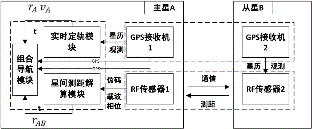
[0042] A satellite formation GPS relative navigation system based on inter-satellite ranging enhancement consists of the following three modules:

[0043] (1) GPS receiver module

[0044] Described GPS receiver module is made up of the GPS receiver 1 that is installed in main star A and the GPS receiver 2 that is installed in from star B; Orbit module and integrated navigation module; GPS observation data and navigation message data acquired by GPS receiver 2 are transmitted to RF sensor 2 through the intra-satellite interface, and transmitted to the main star A through the inter-satellite B ranging module through the inter-satellite link.

[0045] (2) Inter-satellite ranging module

[0046] The inter-satellite ranging module is composed of two RF sensors 1 and 2 installed on the main star and the slave star. The RF sensor includes ...


PUM


Abstract

The invention relates to a satellite formation GPS relative navigation system and method based on enhanced inter-satellite ranging, and relates to the technical field of satellite formation relative navigation. The system consists of a GPS receiver module, an inter-satellite ranging module, and a relative navigation module; the inter-satellite ranging module is composed of two RF sensors, and the inter-satellite ranging pseudo-code is obtained by using a composite pseudocode combined with a dual-frequency two-way forwarding ranging system and carrier phase observations; the relative navigation module is composed of an orbit determination module, an inter-satellite ranging calculation module, and an integrated navigation module. By using the observation data obtained by the GPS receiver module and the inter-satellite ranging module, the extended Kalman filter method is used to solve the problem. Calculate the relative distance and speed data between the stars. The present invention is suitable for inter-satellite formations with an inter-satellite distance of 0-30Km. Compared with a relative navigation system based solely on differential GPS, the real-time relative navigation accuracy is better than 1mm; when the GPS signal is interrupted, the system can still continuously output the relative position that meets the requirements , Velocity data; system initialization time is reduced from dozens of epochs of GPS differential relative navigation system to single point.

Description

technical field [0001] The invention relates to the technical field of satellite formation relative navigation, in particular to a satellite formation GPS relative navigation system and method based on enhanced inter-satellite ranging. Background technique [0002] The relative navigation between satellites in the formation of micro-satellites is the basis of the cooperative work of the formation, and the level of relative navigation accuracy determines the application level that the formation can achieve. The relative navigation system based on differential GPS is currently the main means of satellite formation navigation. Representative applications include: the GRACE double-satellite formation launched in 2002, the inter-satellite baseline determination accuracy of the ground post-processing has reached mm level; the PRISMA launched in 2010 Double-star formation, GPS real-time relative navigation accuracy reaches cm level, post-processing can reach sub-cm level; Canadian ...

Claims


Application Information

Patent Timeline
Patent Type & Authority Applications(China)
IPC IPC(8): G01S19/46
CPCG01S19/46
Inventor 张伟金小军杜耀珂李东俊徐兆斌金仲和孟泽民
Owner ZHEJIANG UNIV
Why Eureka
Try Eureka