Ocean thematic drawing automatic compilation method based on task flow

A thematic map and task flow technology, applied in the field of automatic compilation of marine thematic maps based on task flow, can solve the problems of incompatibility of symbol systems, inconsistent mapping data formats, and inability to display various marine thematic feature maps.

Inactive Publication Date: 2016-12-07
NAT MARINE DATA & INFORMATION SERVICE
View PDF4 Cites 21 Cited by
  • Summary
  • Abstract
  • Description
  • Claims
  • Application Information

AI Technical Summary

Problems solved by technology

Due to the different systems used, the symbol systems between the systems are not compatible with each other, resulting in the use of multiple mapping software in the existing oce

Method used


Image

  • Ocean thematic drawing automatic compilation method based on task flow
  • Ocean thematic drawing automatic compilation method based on task flow

Examples


example

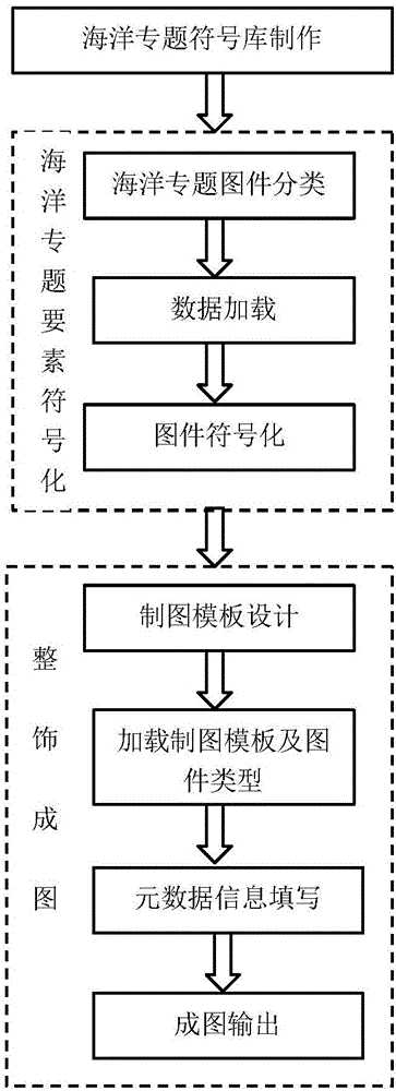
[0107] In order to clearly describe the content of the present invention, the production of a marine functional area division layout is selected to describe the execution steps in detail, as attached figure 1 shown.

[0108] (1) Creation of marine thematic symbol library

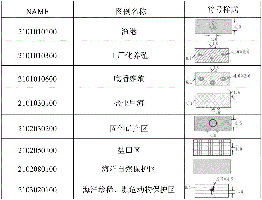
[0109] The ocean functional zoning layer adopts the ESRI Shapefile data format, and the spatial representation is a surface layer, and the Style Manager-NewFill Symbols in Esri Arcmap is used to make surface symbols. In the symbol attribute editor, select "Marker Fill Symol-Marker" for the symbol type, select the symbol style to be filled, and set the CMYK color mode of the fill color. After the symbol is made, it is saved in the haiyang.style file, and its "Name" field is used to name the symbol with the 10-digit code stipulated in the special topic of sea area use in "my country's Coastal Marine Comprehensive Survey Element Classification Code and Diagram Legend Regulations", as shown in the table 1.

...


PUM


Abstract

The invention relates to an ocean thematic drawing automatic compilation method based on a task flow. The method comprises steps of (1) ocean thematic symbol database preparation which divides ocean thematic symbols into 14 classes; (2) ocean thematic element symbolization which comprises ocean thematic drawing classification, data loading and classification drawing symbolization; and (3) diagram finishing which comprises drawing template design, drawing template and drawing type loading, metadata information filling and diagram outputting. The invention firstly unifies standard preparation of ocean drawings, integrates complex ocean elements which cannot be achieved on the GIS platform on a general GIS platform, changes the present situations that lots of drawing software are simultaneously used and drawing data formats are not uniform, and fills gaps of standard, normal and rapid preparation in the domestic ocean thematic drawing field.

Description

technical field [0001] The invention belongs to the technical field of marine information, in particular to an automatic compilation method of marine thematic maps based on task flow. Background technique [0002] Compared with the development of terrestrial cartography, there are still many problems in the production of marine thematic maps. At present, my country's marine departments mainly use GIS platforms such as ArcGIS, ArcInfo, and MapInfo, as well as CorelDraw and AutoCAD professional mapping software to make marine maps, and use matlab and surfer software to draw function maps and contour maps. Due to the different systems used, the symbol systems between the systems are not compatible with each other, resulting in the use of multiple mapping software in the existing ocean thematic maps, the format of the mapping data is not uniform, and various ocean thematic element maps cannot be integrated on a common mapping platform. The status quo shown above. Contents of ...

Claims


Application Information

Patent Timeline
IPC IPC(8): G06T11/20G06T11/60G06F17/24
CPCG06F40/174G06T11/203G06T11/206G06T11/60
Inventor 邢喆樊妙章任群李艳雯张艳杰焦红波王力彦侯辰杨晓彤孙毅
Owner NAT MARINE DATA & INFORMATION SERVICE
Why Eureka
Try Eureka