Infrared thermal imaging monitoring system for airborne network of unmanned aerial vehicle

A technology of infrared thermal imaging and airborne network, which is applied in the field of drones, can solve the problems of inability to expand, inconvenient to carry, and functional limitations, and achieve the effects of not reducing battery life, easy to search and file, and easy to intelligent control

Inactive Publication Date: 2017-01-11
GUANGDONG RONGQE INTELLIGENT TECH CO LTD
View PDF5 Cites 7 Cited by
  • Summary
  • Abstract
  • Description
  • Claims
  • Application Information

AI Technical Summary

Problems solved by technology

[0002] Most of the current infrared thermal imaging technology stays in temperature measurement and online monitoring. Some airborne utility model products (accuracy, sensitivity, clarity, etc.) are evolved from online thermal imaging cameras. The existing thermal imaging equipment is handheld Mobile, fixed scene-based, bulky and inconvenient to carry, limited functions, single application cannot be expanded, a new remote monitoring method, for power inspection, forest fire prevention, fire safety, public security police, environmental aerial survey, individual investigation, etc. Multi-field, has great application prospects

Method used


Image

  • Infrared thermal imaging monitoring system for airborne network of unmanned aerial vehicle
  • Infrared thermal imaging monitoring system for airborne network of unmanned aerial vehicle

Examples


specific Embodiment approach

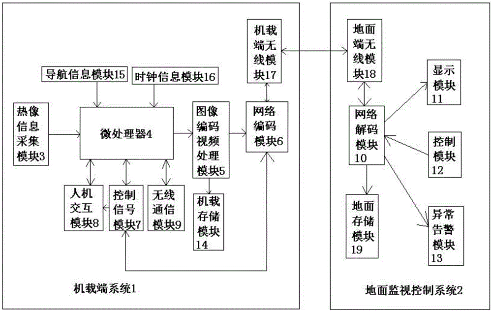
[0014] figure 1 , figure 2 A specific embodiment of the present invention is shown: a UAV airborne network infrared thermal imaging monitoring system, including an airborne end system 1 and a ground monitoring and control system 2, the airborne end system 1 is composed of a thermal image information acquisition module 3, Microprocessor 4, image coding video processing module 5, network coding module 6, control signal module 7, human-computer interaction module 8 and wireless communication module 9, the thermal image information collection module 3 transmits unidirectionally to the processor, The microprocessor 4 transmits one-way to the image encoding video processing module 5, the image encoding video processing module 5 transmits one-way to the network encoding module 6, and the control signal module 7, the network encoding module 6 and the microprocessor 4 all transmit bidirectionally, and control The signal module 7 transmits unidirectionally to the human-computer intera...


PUM


Abstract

The invention discloses an infrared thermal imaging monitoring system for airborne network of unmanned aerial vehicle, comprising an airborne end system and a ground monitoring control system, wherein the airborne end system is composed of thermal imaging information collection module, a micro processor, an image coding video processing module, a network coding module, a control signal module, a man-machine interaction module and a wireless communication module; the ground monitoring control system comprises a network decoding module, a display module, a control module and an abnormal warming module; the system can display the important parameters at the image and video interfaces according to GPS satellite navigation data and clock information; and the infrared thermal imaging monitoring system has great help in the fields of electric inspection, forest fire prevention, fire safety, public security warming, environment aerial survey, individual investigation and so on by brand-new remote monitoring manner.

Description

technical field [0001] The invention relates to the field of unmanned aerial vehicles, in particular to an infrared thermal imaging monitoring system for an airborne network of an unmanned aerial vehicle. Background technique [0002] Most of the current infrared thermal imaging technology stays in temperature measurement and online monitoring. Some airborne utility model products (accuracy, sensitivity, clarity, etc.) are evolved from online thermal imaging cameras. The existing thermal imaging equipment is handheld Mobile, fixed scene-based, bulky and inconvenient to carry, limited functions, single application cannot be expanded, a new remote monitoring method, for power inspection, forest fire prevention, fire safety, public security police, environmental aerial survey, individual investigation, etc. It has great application prospects in many fields. Contents of the invention [0003] The technical problem to be solved by the present invention is to provide a UAV airb...

Claims


Application Information

Patent Timeline
Patent Type & Authority Applications(China)
IPC IPC(8): H04N7/18H04N5/33H04N5/77G01J5/00G05B19/042
CPCH04N7/181G01J5/00G05B19/042H04N5/33H04N5/77
Inventor 刘铭青叶茂林陈建伟
Owner GUANGDONG RONGQE INTELLIGENT TECH CO LTD
Why Eureka
Try Eureka