Filtering method and device for point cloud data

A technology of point cloud data and filtering algorithm, applied in the field of data processing, can solve the problems of increasing labor cost and poor effect, and achieve the effect of ensuring accuracy and precision and improving filtering efficiency.

Inactive Publication Date: 2017-02-15
BEIJING GREEN VALLEY TECH CO LTD
View PDF0 Cites 26 Cited by
  • Summary
  • Abstract
  • Description
  • Claims
  • Application Information

AI Technical Summary

Problems solved by technology

There are many related studies on filtering methods, such as morphological filtering, slope-based filtering, and surface-based filtering. The effect is poor in areas with complex object types, especially in dense forest areas, which usually requires manual editing to achieve the ideal filtering effect, which increases labor costs

Method used


Image

  • Filtering method and device for point cloud data
  • Filtering method and device for point cloud data
  • Filtering method and device for point cloud data

Examples


Embodiment 1

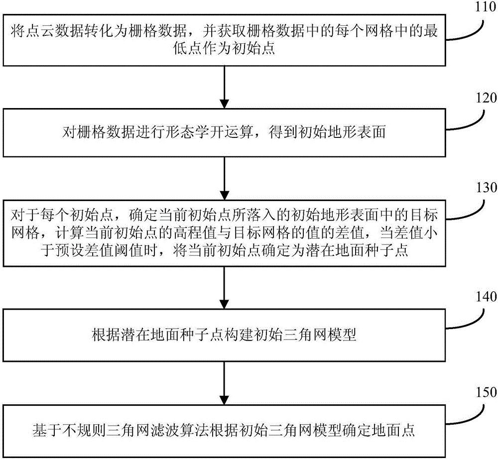
[0039] figure 1 It is a schematic flow chart of a point cloud data filtering method provided by Embodiment 1 of the present invention. The method can be executed by a point cloud data filtering device, wherein the device can be implemented by software and / or hardware, and generally can be integrated in a terminal such as a computer middle. like figure 1 As shown, the method includes:

[0040] Step 110, converting the point cloud data into raster data, and obtaining the lowest point in each grid in the raster data as an initial point.

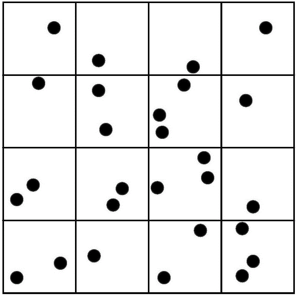
[0041] Exemplarily, rasterization processing is performed on the point cloud data to obtain raster data. For example, point cloud data can be divided into rectangular grid rules to obtain raster data. In this embodiment, the precision of rasterization processing can be set according to actual requirements, for example, the size of each grid can be 1 meter*1 meter. figure 2 A schematic diagram of a grid provided in Embodiment 1 of the prese...

Embodiment 2

[0053] Figure 5 It is a schematic flow chart of a point cloud data filtering method provided by Embodiment 2 of the present invention. This embodiment is optimized on the basis of the above-mentioned embodiments. In this embodiment, the step "according to the potential ground seed point and the initial ground seed Points to build an initial triangulation model" has been optimized.

[0054] Correspondingly, the method of this embodiment includes the following steps:

[0055] Step 510, converting the point cloud data into raster data, and obtaining the lowest point in each grid in the raster data as an initial point.

[0056] Step 520, performing morphological opening operation on the grid data to obtain an initial terrain surface.

[0057] Step 530, for each initial point, determine the target grid in the initial terrain surface where the current initial point falls, and calculate the difference between the elevation value of the current initial point and the value of the ta...

Embodiment 3

[0067] Image 6 It is a schematic flowchart of a point cloud data filtering method provided by Embodiment 3 of the present invention. This embodiment is optimized on the basis of the above-mentioned embodiments. In this embodiment, the step "constructing an initial triangulation network based on initial ground seed points model" has been optimized.

[0068] Correspondingly, the method of this embodiment includes the following steps:

[0069] Step 610, converting the point cloud data into raster data, and acquiring the lowest point in each grid in the raster data as an initial point.

[0070] Step 620, performing morphological opening operation on the grid data to obtain an initial terrain surface.

[0071] Step 630, for each initial point, determine the target grid in the initial terrain surface where the current initial point falls, and calculate the difference between the elevation value of the current initial point and the value of the target grid, when the difference is ...


PUM


Abstract

An embodiment of the invention discloses a filtering method and a filtering device for point cloud data. The filtering method comprises the steps of: converting the point cloud data into raster data, and acquiring the lowest point in each raster as the initial point; performing morphological opening operation on the raster data to obtain an initial terrain surface; for each initial point, determining the current initial point as a potential ground seed point if a difference value between an elevation value of the current initial point and a value of the target raster which the current initial point falls into; constructing an initial triangulation network model according to the potential ground seed point; and determining a ground point according to the initial triangulation network model based on an irregular triangulation network filtering algorithm. By adopting the filtering method and the filtering device, the ground seed point can be reasonably determined, and the filtering efficiency is improved while guaranteeing the accuracy and precision of the initial triangulation network model, thereby the ground point in the point cloud data can be screened quickly and accurately.

Description

technical field [0001] Embodiments of the present invention relate to the technical field of data processing, and in particular to a method and device for filtering point cloud data. Background technique [0002] Airborne laser detection and ranging (LiDAR), also known as airborne laser radar, is an emerging three-dimensional data acquisition method, which can quickly obtain high-spatial-resolution three-dimensional coordinates of ground objects, with time and space resolution. It has the advantages of high rate, large observation range, high operation efficiency and the ability to penetrate forests. It is widely used in basic surveying and mapping, urban planning, 3D reconstruction, forestry survey and power line inspection and other fields. [0003] Lidar point cloud data contains both ground points and non-ground points. Filtering is the process of separating ground points and non-ground points from point cloud data. It uses point cloud data to generate high-precision dig...

Claims


Application Information

Patent Timeline
Patent Type & Authority Applications(China)
IPC IPC(8): G06T7/40G06T17/05G01S17/89
CPCG06T17/05G06T2207/20024G06T2207/20036G01S7/4808G01S17/89
Inventor 郭彦明
Owner BEIJING GREEN VALLEY TECH CO LTD
Why Eureka
Try Eureka