System for realizing centimeter-level precision GPS positioning in ARM platform

A GPS positioning and centimeter-level technology, applied in the field of positioning systems, can solve the problems of high equipment cost, high power consumption, and poor portability, and achieve the effects of low-cost equipment, reduced errors, and low-cost manufacturing

Inactive Publication Date: 2017-02-22
广州知春里网络科技有限公司
View PDF4 Cites 2 Cited by
  • Summary
  • Abstract
  • Description
  • Claims
  • Application Information

AI Technical Summary

Problems solved by technology

At present, limited by the algorithm efficiency of RTKLIB, the operating environment and the development level of related hardware, the current RTK computing system is huge, requiring high computing power, high power consumption, and many equipment components,

Method used


Image

  • System for realizing centimeter-level precision GPS positioning in ARM platform
  • System for realizing centimeter-level precision GPS positioning in ARM platform

Examples


Example Embodiment

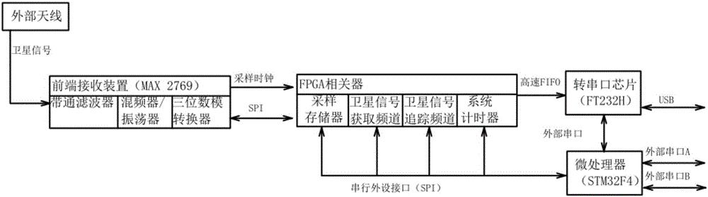
[0022] Such as figure 1 As shown, the present invention includes a front-end receiving device, FPGA correlator (programmable chip control module), and a microprocessor integrated on the board; among them, the front-end receiving device is used to filter the satellite signal received by the external antenna and reduce the frequency. And discretization processing; then the satellite signal stream digitized by the front-end receiving device is sent to the FPGA correlator, and the FPGA correlator performs further filtering and correlation calculations on the satellite signal stream, and then passes through the serial peripheral interface SPI ( Serial Peripheral Interface (Serial Peripheral Interface) connected to the microprocessor can read and write and control the modules in the FPGA correlator, collect the solution results, and perform position / speed / time RTK on the processed satellite signal stream Solve. The specific settings are as follows:

[0023] The front-end receiving dev...


PUM


Abstract

The invention discloses a system for realizing centimeter-level precision GPS positioning in an ARM platform. The system for realizing the centimeter-level precision GPS positioning in the ARM platform comprises a front receiving device integrated on a board card, an FPGA correlator and a micro-processor. The front receiving device is used for receiving a satellite signal through an external antenna, and is integrated with a band-pass filter, a mixer/oscillator and a three-position digital analog converter. The FPGA correlator is used for performing the further filtering and the correlation analysis to the satellite signal, and is integrated with a sample memory, a satellite signal obtaining channel, a satellite signal tracking channel and a system timer. The micro-processor is used for receiving the intermediate calculation result output by the FPGA correlator, and executing all calculations on the FPGA correlator, and outputting the real time carrier phase difference position and speed result. The system for realizing the centimeter-level precision GPS positioning in the ARM platform is capable of performing the deep optimization to the solution algorithm of the ambiguity of whole cycles so as to enable the real time positioning of the centimeter-level, effectively reducing the error caused by the carrier phase measurement, and realizing the manufacture and application of the RTK micromation and low cost device.

Description

technical field [0001] The invention relates to a positioning system, in particular to a system for realizing centimeter-level precision GPS positioning on an ARM platform. Background technique [0002] The Global Positioning System (GPS, global positioning system) is a system that uses positioning satellites to perform real-time positioning and navigation around the world. With the development of intelligent terminal equipment, GPS positioning technology is widely used in different fields. Single-point positioning, or absolute positioning, is the most commonly used method in GPS positioning technology. It determines the position of the GPS receiver on the earth through the distance between the GPS receiver and four or more known satellites. The measurement distance error between the GPS receiver and the known satellites, such as the satellite clock error and the time measurement error caused by the ionospheric delay when the satellite signal returns, is the most important ...

Claims


Application Information

Patent Timeline
IPC IPC(8): G01S19/41
CPCG01S19/41
Inventor 凌满江
Owner 广州知春里网络科技有限公司
Why Eureka
Try Eureka