High-efficiency real-time electronic map fence realization method based on big data

An electronic map and electronic fence technology, applied in the direction of electronic digital data processing, structured data retrieval, geographic information database, etc., can solve the problems of limited electronic map fence, low efficiency, poor user experience, etc., to improve efficiency and flexibility Sexuality, the ability to increase money, the effect of reducing maintenance costs

Inactive Publication Date: 2017-03-08
杨庆磊
View PDF0 Cites 9 Cited by
  • Summary
  • Abstract
  • Description
  • Claims
  • Application Information

AI Technical Summary

Problems solved by technology

[0006] This data update method is inefficient, low in real-time performance, and poor in user experience. It is often necessary to download the electronic map fence information of the entire area to update one or two warning messages or prompt messages.
In addition, information update depends on users' active or passive downloading, which will cause the system to monitor users' downloading behavior to confirm which users have not updated, which increases the development cost of the location service system
[0007] The reason why the electronic map fence adopts the above method is mainly limited by the traditional relational database technology
The electronic map fence information stored in the location service system is as high as hundreds of thousands of rows. When a user enters or exits the electronic map fence area, the system needs to perform large-scale queries on these hundreds of thousands of rows of data, which greatly consumes the performance of the server. When the number of users is tens of thousands, the location service system will collapse

Method used


Image

  • High-efficiency real-time electronic map fence realization method based on big data
  • High-efficiency real-time electronic map fence realization method based on big data
  • High-efficiency real-time electronic map fence realization method based on big data

Examples


Embodiment Construction

[0036] In order to better understand the technical content of the present invention, specific embodiments are given together with the attached drawings for description as follows.

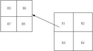
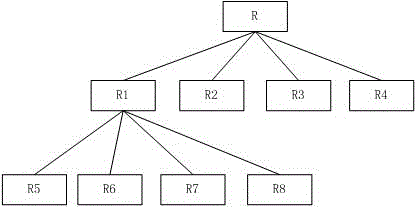
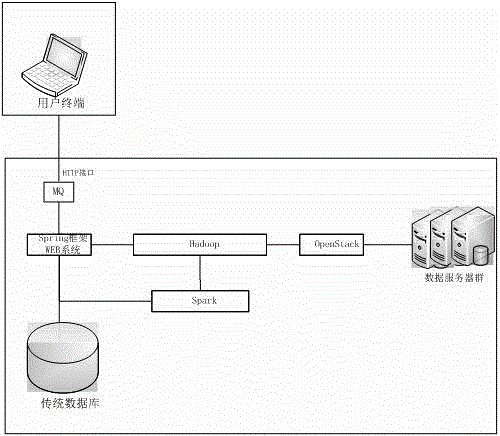
[0037] In this example, if figure 1 As shown, the big data platform is as follows:

[0038] MQ: It is the message queue component of the system, which is used to receive the location information reported by the terminal through the Internet.

[0039] Spring framework WEB system: the main function is to provide an interface for human-computer interaction, that is, you can set and manage electronic map fence information through the WEB interface, and you can also query the status of each terminal entering and leaving the electronic fence through the interface.

[0040] Traditional database: the traditional relational database, generally MySQL and Oralce, mainly considering that the data of some location service systems still use the traditional database method, so this patent still uses the traditio...


PUM


Abstract

The invention discloses a high-efficiency real-time electronic map fence realization method based on big data. Distributed storage of high-efficiency real-time electronic map fence information is realized through adoption of architecture of big data; the electronic map fence information is searched through distributed computation; and information indicating that a user terminal enters or exits an electronic map is triggered. The method comprises the steps that when the electronic map fence information is added to a system, the electronic map fence information is stored in a distributed storage component Hadoop, and an index is added to the electronic map fence information; when an information queue of the system receives position information of the user terminal, the position information is transmitted to a distributed computation component Spaprk for processing and the distributed storage component Hadoop for information backup; and the distributed computation component Spaprk receives the position information of the user terminal, the electronic map fence information around users is searched rapidly and corresponding temporary files are generated; and when the system detects that a certain user terminal enters or exits a certain electronic map fence, corresponding information is triggered to be sent to the user terminal.

Description

technical field [0001] The invention relates to the fields of big data, cloud computing and location services, in particular to a method for realizing an electronic map fence based on big data, which is efficient, real-time and manageable in the background. Background technique [0002] In the location service system, the electronic map fence is a very important function, that is, to delineate a specific area on the online map or GIS map. The shape of this area is often circle, rectangle, triangle and polygon. Or exit the area, the system will generate and push various messages. [0003] The electronic map fence is an extremely widely used function, including the preservation of important objects, the prevention of loss of the elderly and children, the management of hazardous chemicals, anti-aircraft and anti-riot, and electronic tour guides. [0004] At present, the electronic map fence of most location systems is mainly stored on the terminal offline. If the electronic ma...

Claims


Application Information

Patent Timeline
Patent Type & Authority Applications(China)
IPC IPC(8): G06F17/30
CPCG06F16/29
Inventor 杨庆磊
Owner 杨庆磊
Why Eureka
Try Eureka