Riparian sludge thickness calculating and mapping method based on kriging interpolation

A kriging interpolation and silt technology, which is applied in the field of silt thickness calculation and mapping in waterfront zone based on kriging interpolation, can solve the problems of high equipment requirements and lack of operation experience, achieve high precision and efficiency, improve The effect of work efficiency and work accuracy

Active Publication Date: 2017-03-08
NANJING FORESTRY UNIV
View PDF2 Cites 14 Cited by
  • Summary
  • Abstract
  • Description
  • Claims
  • Application Information

AI Technical Summary

Problems solved by technology

However, the use of surveying and mapping unmanned ships to study the thickness of silt, due to the high requirements for equipment, currently lacks practical operational experience in the work

Method used


Image

  • Riparian sludge thickness calculating and mapping method based on kriging interpolation
  • Riparian sludge thickness calculating and mapping method based on kriging interpolation
  • Riparian sludge thickness calculating and mapping method based on kriging interpolation

Examples


Embodiment 1

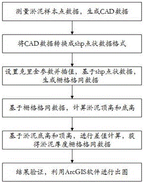
[0042] A Kriging interpolation-based method for calculating and drawing silt thickness in the waterfront zone, the flow chart is as follows figure 1 As shown in , the specific steps are as follows:

[0043] 1) Measure the mud sample point data and generate CAD data.

[0044] Use the shore-end server to survey and map the unmanned ship to set the route and target point. Determine the starting point and ending point of the river channel, and then set the time interval of unmanned ship measurement to 1 time / second, and the sampling route adopts a zigzag sampling route. Input the pre-set route into the control system, so that the unmanned ship can automatically cruise and measure data. The measured data is saved in the DXF format of CAD software.

[0045] 2) Convert CAD data into shp point format data.

[0046]The shp format is an abbreviation of the shapefile format, which is developed by ESRI. A shp file includes a main file, an index file, and a dBASE table. The reason for ...

Embodiment 2

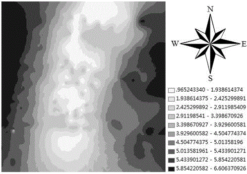
[0075] Taking the Shuiximen River Section of Nanjing City, Jiangsu Province as an example, the method of Embodiment 1 is used for on-the-spot measurement. The computer hardware used in this embodiment is mainly: the CPU is an i5 processor, the memory is 8GB, and the hard disk is a solid state disk. The software used is: the operating system is windows 7 professional edition system, and the ArcGIS software is version 9.3.1.

[0076] (1) Firstly, convert the format of the collected point data. In order to use the kriging interpolation algorithm in ArcGIS software, the original format needs to be converted into shapefile format data. The data format directly measured by the surveying and mapping unmanned ship is the DXF format of CAD. After opening it with ArcGIS software, select "*.dxf Point", right-click, select Data in the pop-up window, and then Export Data, you can export It converts to shapefile format.

[0077] (2) The second is to construct kriging regular grid raster d...


PUM


Abstract

The invention discloses a riparian sludge thickness calculating and mapping method based on a kriging interpolation. The riparian sludge thickness calculating and mapping method include: utilizing shipborne RTK (real-time kinematic) surveying equipment and a sonar to acquire point data; subjecting high-frequency point data and low-frequency point data to common kriging grid interpolation respectively to form regular grid data in two frequency bands; calculating data of a sludge top and a sludge bottom by combining with fixed parameter settings like a pole height so as to obtain a sludge height, and performing grid calculation by ArcGIS to obtain a spatial sludge thickness map. According to the riparian sludge thickness calculating and mapping method based on the kriging interpolation, an unmanned ship is applied to riparian sludge thickness surveying and mapping, and working efficiency and working accuracy of surveying and mapping can be increased. Verified by field testing and mapping in the Shuiximen reach in Nanjing, the riparian sludge thickness calculating and mapping method based on the kriging interpolation is high in precision and efficiency, and capable precisely measuring typical riparian sludge at the bottom of a river effectively and providing technical support for riparian soil research.

Description

technical field [0001] The invention belongs to the technical field of measuring silt thickness, and in particular relates to a Kriging interpolation-based calculation and drawing method for silt thickness in a waterfront zone. Background technique [0002] The lakeside waterfront zone is one of the ecological interlaced types between terrestrial ecosystems and aquatic ecosystems, with high productivity and significant ecological edge effects. The river bottom soil in the lakeside waterfront zone has been in an anaerobic and aerobic environment for a long time, and organic matter is strongly accumulated and decomposed slowly, so the organic matter is rich. Determination of the thickness of river bottom silt in the waterfront zone has important reference significance for the study of soil characteristics in the waterfront zone and the sampling and extraction of active organic carbon. In the original method of measuring the thickness of silt, in general, the operator must go ...

Claims


Application Information

Patent Timeline
Patent Type & Authority Applications(China)
IPC IPC(8): G06F17/50G01S15/02G01S15/08G01S19/43G01S19/45
CPCG01S15/08G01S19/43G01S19/45G01S15/86G06F2111/10G06F30/20
Inventor 许子乾蒋圣羌鑫林钱程扬曹林阮宏华
Owner NANJING FORESTRY UNIV
Why Eureka
Try Eureka