Ground-GPS-assisted method for correcting error of difference of elevation of LiDAR data

An error correction and elevation difference technology, applied in the field of surveying and mapping science, can solve problems such as correcting elevation errors of point cloud data

Active Publication Date: 2017-04-26
CHANGAN UNIV
View PDF3 Cites 19 Cited by
  • Summary
  • Abstract
  • Description
  • Claims
  • Application Information

AI Technical Summary

Problems solved by technology

In the actual production of LiDAR data processing, it is found that the elevation error of point cloud is generally between 0.3m and 1.0m. At present, there is no systematic method for correcting the elevation error of point cloud data.

Method used


Image

  • Ground-GPS-assisted method for correcting error of difference of elevation of LiDAR data
  • Ground-GPS-assisted method for correcting error of difference of elevation of LiDAR data
  • Ground-GPS-assisted method for correcting error of difference of elevation of LiDAR data

Examples


Embodiment Construction

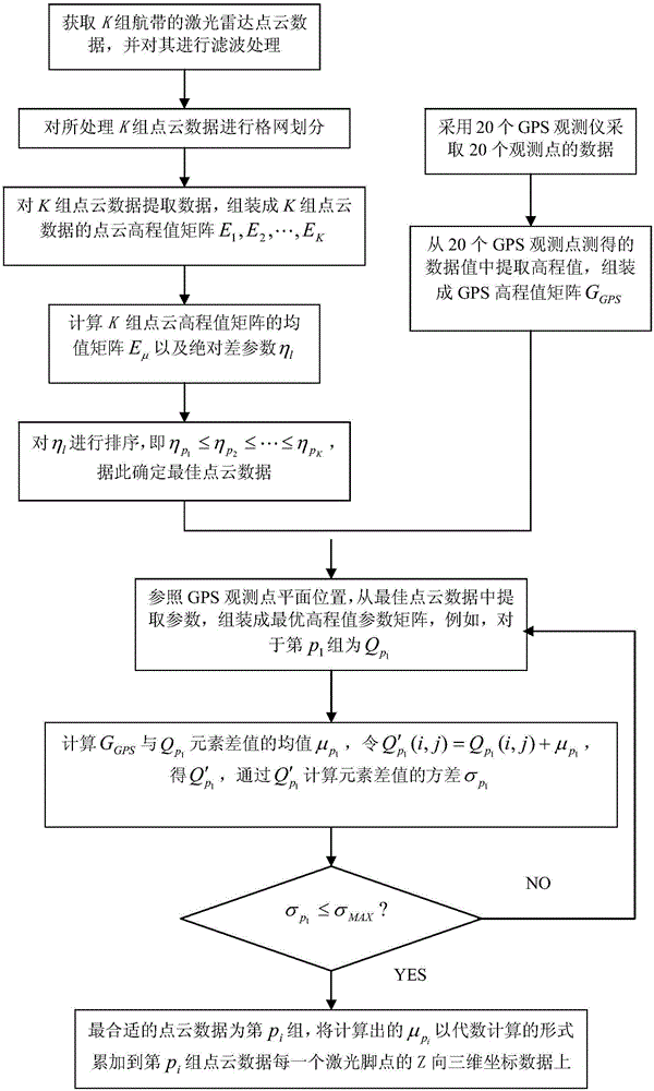
[0019] The present invention will be further described below in conjunction with drawings and embodiments.

[0020] The implementation steps of the present invention are as follows, see figure 1 :

[0021] Step 1: After using the airborne lidar to carry out K sorties to the survey area from first to last, obtain the lidar point cloud data containing K flight belts. In order to prevent the interference of invalid point cloud data groups, K≥3; The laser radar point cloud data of a flight strip includes the measurement data of multiple laser foot points, and the measurement data of each laser foot point includes the (X, Y, Z) three-dimensional coordinate data and measurement data of the laser foot point Get Time;

[0022] Filter the original point cloud data, remove vegetation and buildings, and only leave valid surface point cloud data, the data includes the (X, Y, Z) three-dimensional coordinate data of the laser foot point and the acquisition time of the measurement data;

...


PUM


Abstract

The invention provides a ground-GPS-assisted method for correcting the error of the difference of elevation of LiDAR data. The method comprises: an onboard LiDAR device performs repeated measurement on a measured geomorphic object for K times to obtain K groups of air strip point cloud data; the point cloud data is subjected to gross error elimination and regular grid; before the onboard LiDAR measurement, a certain number of ground GPS measurers have been arranged in an tested air strip to measure the absolute position of a ground point; an absolute difference parameter [eta]l is used for optimal ordering on the obtained K groups of point cloud data; an elevation value of the absolute position of the ground point measured by GPS is compared with an elevation value parameter corresponding to the optimal point cloud data to obtain the elevation error variance, and according to the variance, point cloud data that may be subjected to error correction is determined, and eventually accurate LiDAR data is obtained through correction.

Description

technical field [0001] The invention belongs to the field of surveying and mapping science and technology, and relates to a ground GPS-assisted airborne laser point cloud error correction method, which is mainly used in the fields of high-precision DEM / DSM production, urban three-dimensional modeling, and high-precision landform feature picking. Background technique [0002] The airborne LiDAR (Light Detection And Ranging) system is an emerging measurement technology that quickly collects surface information. The elevation accuracy on hard open ground can be as high as 15cm, and the plane accuracy is better than 30cm. It is often used to obtain dense and accurate data in large areas Terrain and feature data. At present, it has been widely used in power line inspection, highway line selection, forest parameter estimation, 3D city modeling and other fields. The airborne LiDAR system is composed of laser scanner, GPS / IMU (Inertial Measurement Unit) inertial navigation device, c...

Claims


Application Information

Patent Timeline
Patent Type & Authority Applications(China)
IPC IPC(8): G01S7/497
CPCG01S7/497
Inventor 韩毅赵伟伟李凌伊
Owner CHANGAN UNIV
Why Eureka
Try Eureka