
Map construction system based on intelligent robot and map navigation method based on intelligent robot

An intelligent robot and map construction technology, applied in the field of intelligent robots, can solve problems such as narrow space, large GPS positioning error, and GPS positioning that cannot meet the accuracy requirements, and achieve the effect of strong adaptability, high efficiency and accuracy

Inactive Publication Date: 2017-05-10
SHANGHAI YAO WEI GROUP IND
View PDF4 Cites 18 Cited by
  • Summary
  • Abstract
  • Description
  • Claims
  • Application Information

AI Technical Summary

Problems solved by technology

However, there are still some problems in navigation and positioning in unknown spaces, mainly including the fact that most of the existing GPS positioning is used. The space is narrow and the structure is complex, and GPS positioning cannot meet the accuracy requirements; especially in a space with a large area or a lot of obstacles, it is limited by the performance of scanners and sensors, detection range, and massive data, and real-time positioning can only be achieved at the expense of performance. scan modeling

Method used


Image

  • Map construction system based on intelligent robot and map navigation method based on intelligent robot
  • Map construction system based on intelligent robot and map navigation method based on intelligent robot
  • Map construction system based on intelligent robot and map navigation method based on intelligent robot

Examples


Embodiment Construction

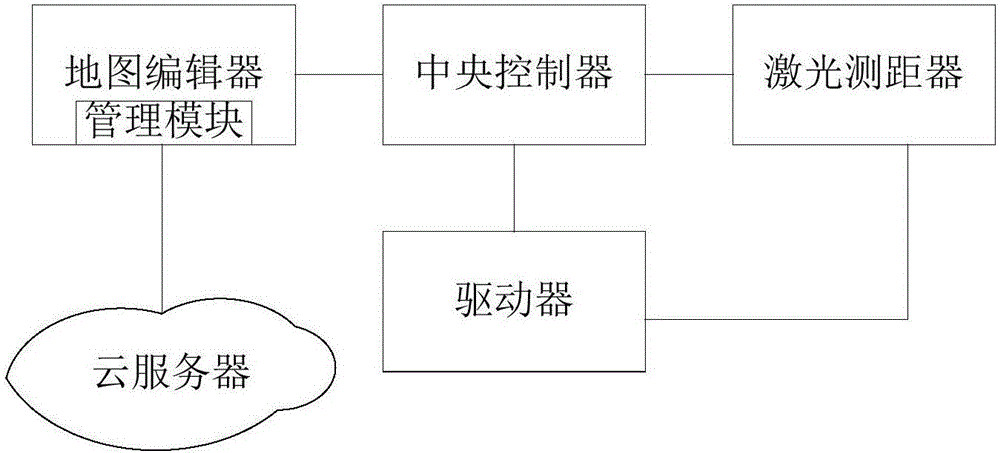
[0026] Such as figure 1 As shown, the schematic diagram of the intelligent robot-based map construction system of the preferred embodiment of the present invention includes a central controller, a driver, a map editor and a laser rangefinder.

[0027] The driver is used to drive the robot to make corresponding mechanical movements according to the instructions issued by the central controller (for example, to drive the robot to perform body movements including shaking the head, waving the arm, etc.), which includes driving the robot to perform rotational mechanical movements to adjust the angle detected by the laser rangefinder and Including driving the robot to move (for example, the laser rangefinder is installed on the head of the robot, the driver controls the rotation direction of the robot's head to adjust the angle detected by the laser rangefinder, or the driver controls the movement of the pulley on the base of the robot);

[0028] The laser range finder uses a DM / SL ...


PUM


Abstract

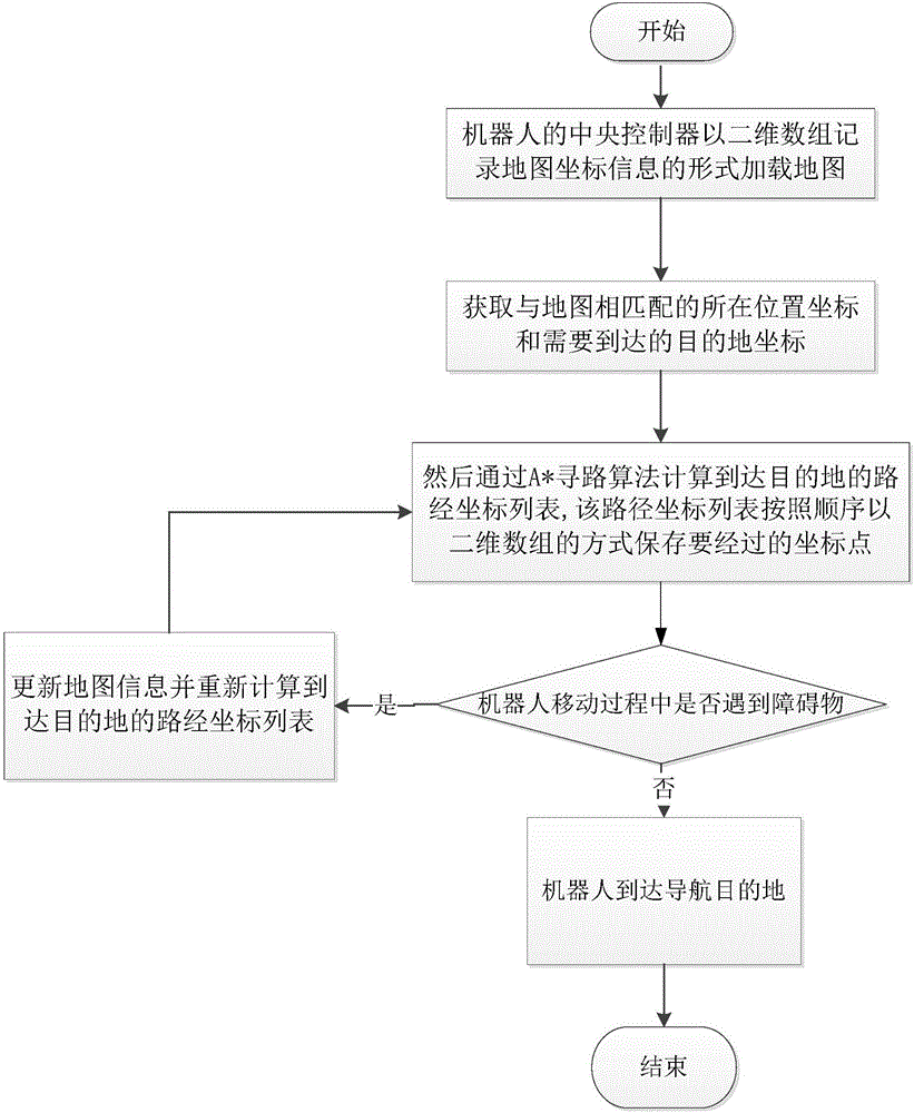
The present invention discloses a map construction system based on an intelligent robot and a map navigation method based on an intelligent robot. The system comprises a central controller, a driver, a map editor and a laser distance measurement device. The driver is configured to drive a robot to do corresponding mechanical motion according to an instruction emitted by a central control unit, and the mechanical motion comprises driving the robot to do the rotation mechanical motion to regulate the angle detected by the laser distance measurement device and driving the robot to do movement motion. The central controller is configured to send work state parameters of the laser distance measurement device and the collected data information to the map editor to generate a map. The central controller of the robot loads a map in the mode of recording the information of map coordinates through adoption of a two-dimensional array and obtains coordinates of the position matching the map and the coordinates of a destination requiring arrival; a path coordinate list of destination arrival is calculated through adoption of the way-finding algorithm; and the robot is moved to the destination according to the path coordinate list.

Description

technical field [0001] The invention relates to the field of intelligent robots, in particular to an intelligent robot-based map construction system and map navigation method. Background technique [0002] At present, with the rapid development of intelligent robot technology, various service robots have entered people's sight, such as: children's chatting robots and intelligent customer service robots, food delivery robots in restaurants, etc. But at present, the robot can only move according to the preset fixed route. In the application of the robot, navigation and positioning are the key functions of the robot system. Navigation means that the mobile robot obtains environmental information and its own position and posture state through sensors, and realizes autonomous movement to the destination in the environment of obstacles. The key and premise of navigation is positioning, which refers to determining the position and posture of the robot itself in the environment in ...

Claims


Application Information

Patent Timeline
IPC IPC(8): G01S17/89G01S17/42G01C21/20
CPCG01S17/89G01C21/20G01C21/206G01S17/42
Inventor 姚剑姚薇施君
Owner SHANGHAI YAO WEI GROUP IND
Learn More