Auxiliary information system and method of remote-sensing monitoring for mineral resource exploitation environment

A mineral resource and remote sensing monitoring technology, which is applied in the directions of surveying devices, surveying and navigation, photogrammetry/video metrology, etc., can solve problems such as lowering work efficiency and monitoring accuracy, lowering data accuracy, and limiting efficiency, so as to improve work efficiency. Efficiency and monitoring accuracy, the process of interpretation is intuitive, and the effect of improving accuracy

Active Publication Date: 2017-05-10
YUNNAN UNIV
View PDF4 Cites 15 Cited by
  • Summary
  • Abstract
  • Description
  • Claims
  • Application Information

AI Technical Summary

Problems solved by technology

In the practice of remote sensing monitoring projects for the national mineral resource development environment, the workload involved is large and complex, often requiring multiple application software platforms to complete the work together, and the data between different software needs to be converted, resulting in reduced data accuracy and time-consuming. This greatly reduces work efficiency and monitoring accuracy
[0005] (2) The degree of automation of remote sensing monitoring of mineral resources development environment is low
It is manifested in the attribute filling in the remote sensing monitoring project of mineral resources de

Method used


Image

  • Auxiliary information system and method of remote-sensing monitoring for mineral resource exploitation environment
  • Auxiliary information system and method of remote-sensing monitoring for mineral resource exploitation environment
  • Auxiliary information system and method of remote-sensing monitoring for mineral resource exploitation environment

Examples


Embodiment 1

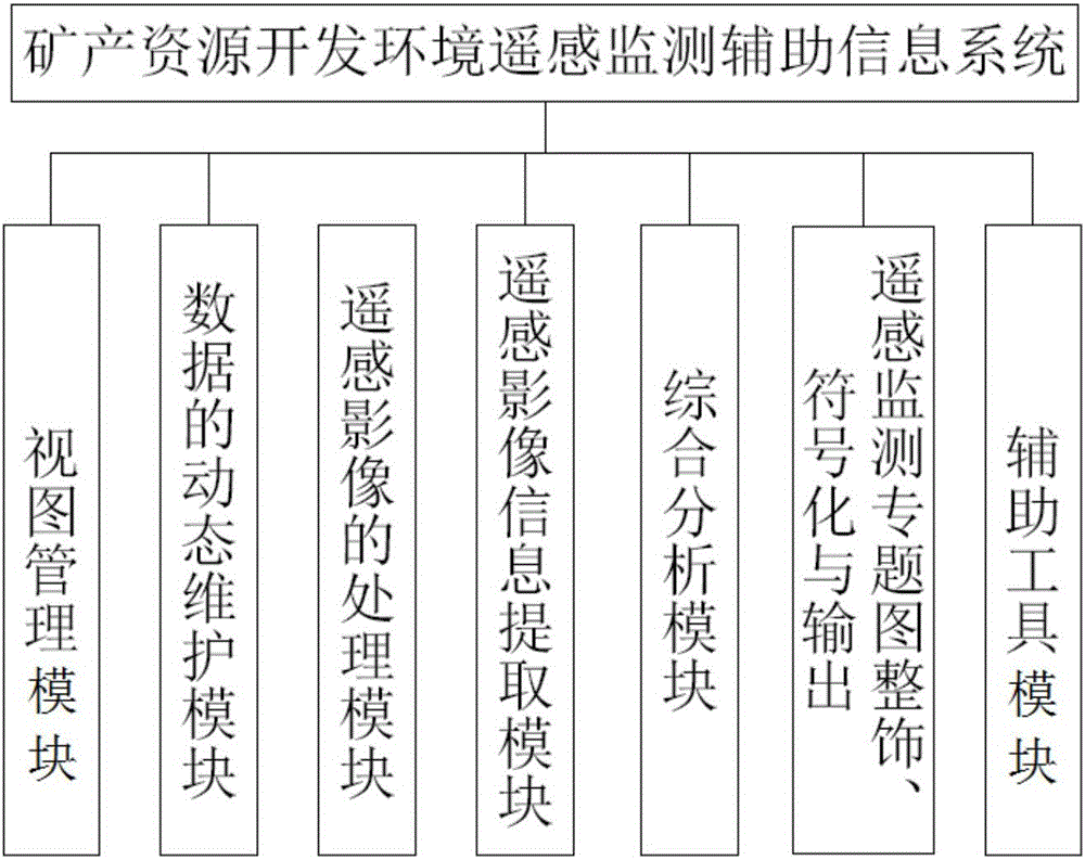
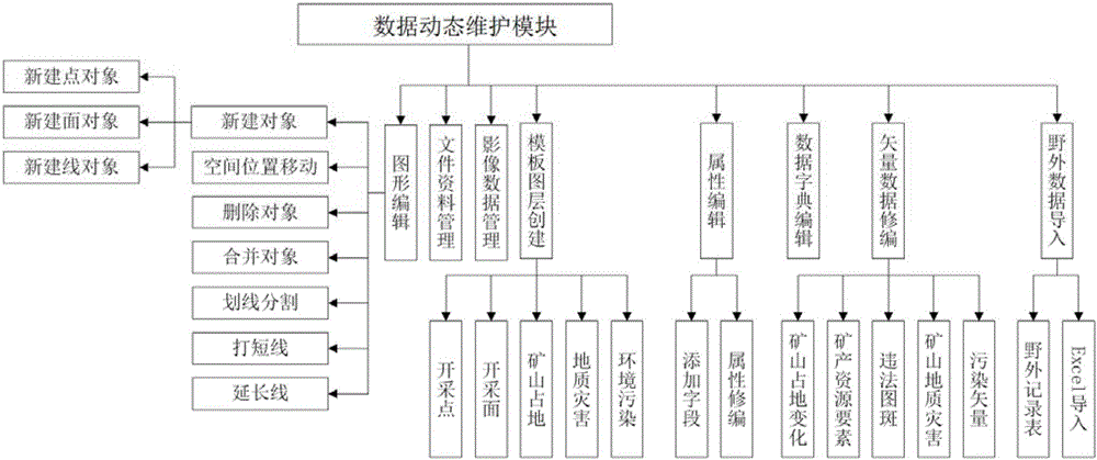
[0045] The remote sensing monitoring auxiliary information system for mineral resources development environment includes 7 functional modules (such as Figure 1 to Figure 8 shown).

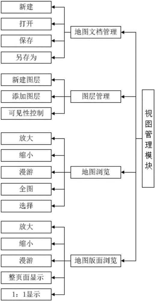
[0046] (1) The view management module is the management of map documents and layers, and the browsing operation of map views and layout views.

[0047] A map document is a project file, which saves the map's spatial reference, layer order, layer display symbols, and the path of each layer file. The management operations of the map document include four types: new, open, save, and save as. The next time you open the map document, it will be consistent with the last saved map, and there is no need to reset the relevant parameters. Map management includes two aspects: horizontal and vertical. The horizontal is reflected by framing, and the vertical is managed by layers.

[0048] Layer management includes creating new layers, deleting layers, adding layers, and layer visibility control, where the ne...

Embodiment 2

[0076] On the basis of fully collecting remote sensing image data, mining rights data and other data in the monitoring area, carry out remote sensing monitoring work in three aspects: mineral resource development status, mine geological environment problems, and mineral resource planning implementation. Through data processing, combined with human-computer interactive interpretation, the data required for remote sensing monitoring of mineral resources development environment are obtained, field verification is carried out, and combined with field verification, the interpretation information is modified and improved, and the monitoring area is comprehensively analyzed and analyzed. Evaluation, and then form a comprehensive analysis and evaluation report, and submit relevant results maps, reports and statements, as well as all original data and materials on time and as required.

[0077] The monitoring method includes the following steps:

[0078] Step (1) Fully collect remote s...


PUM


Abstract

The invention discloses an auxiliary information system and method of remote-sensing monitoring for mineral resource exploitation environment. The auxiliary information system comprises a remote sensing image processing module, a remote sensing image information extraction module and an integrated analysis module; the remote sensing image processing module processes a remote-sensing image by fusion, inlay, cutting and enhancement; the remote sensing image information extraction module comprises a 2D and 3D linked interpretation unit, a man-machine interaction interpretation unit and an automatic discrimination unit of a suspected illegal patch; and the integrated analysis module modifies and improves interpretation information via field verification, and analyzes a mineral resource plan execution condition, a mineral product resource exploitation status and mineral geological environment problems in an integrated manner. According to the system and method, a 2D and 3D linked interpretation mechanism is established, so that an interpretation process is more visual and the interpretation accuracy is improved; according to mineral and interpretation data as well as attribute data, the suspected illegal patch can be discriminated automatically; and the system can improve the working efficiency and monitoring precision greatly.

Description

technical field [0001] The invention relates to the technical field of mineral resource development monitoring, in particular to an auxiliary information system and method for remote sensing monitoring of the mineral resource development environment. Background technique [0002] For a long time, in the development and utilization of mineral resources in our country, there have been illegal acts such as "cross-border mining", "mining without a license", "replacing exploration with mining", "changing mining types without authorization" and "changing mining methods without authorization". It wastes national resources and destroys the natural environment, causing a series of natural environmental problems such as mine geological disasters, mine environmental pollution, and land occupation, and often threatens the safety of people's lives and property. For this reason, the State Council launched a nationwide rectification of mineral resource development order in 1995 and 2005 in...

Claims


Application Information

Patent Timeline
IPC IPC(8): G06Q50/02G01C11/00
CPCG01C11/00G06Q50/02
Inventor 谈树成王超赵志芳
Owner YUNNAN UNIV
Why Eureka
Try Eureka