
Positioning method and mobile robot based on multiple navigation modules

A mobile robot and navigation module technology, which is applied in satellite radio beacon positioning systems, instruments, electromagnetic wave re-radiation, etc., can solve the problems of low positioning accuracy, insufficient positioning, and affect the smooth progress of navigation, so as to improve navigation stability performance, overcome limitations and system errors, and expand the effect of adapting to the operating environment

Inactive Publication Date: 2017-07-04
ANKE SMART CITY TECH PRC
View PDF6 Cites 39 Cited by
  • Summary
  • Abstract
  • Description
  • Claims
  • Application Information

AI Technical Summary

Problems solved by technology

This method is easy to implement and the algorithm is simple, but it needs to arrange a large number of reflectors on site, the cost is high, and the laser must accurately hit the reflectors to work effectively, the working environment requires high requirements, and the positioning accuracy is not high
[0007] It can be seen that the above-mentioned integrated navigation method requires special layout of the site, and there are technical problems such as inaccurate positioning, which affects the smooth progress of navigation

Method used


Image

  • Positioning method and mobile robot based on multiple navigation modules
  • Positioning method and mobile robot based on multiple navigation modules
  • Positioning method and mobile robot based on multiple navigation modules

Examples


Embodiment Construction

[0047] It should be understood that the specific embodiments described herein are only used to explain the present invention, but not to limit the present invention.

[0048] In the following description, suffixes such as 'module', 'component' or 'unit' used to represent elements are used only to facilitate the description of the present invention, and have no specific meaning per se. Therefore, "module" and "part" can be mixed.

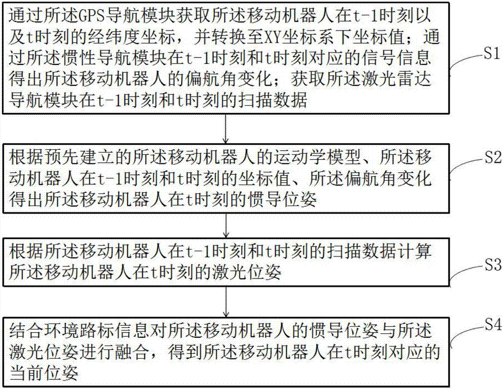
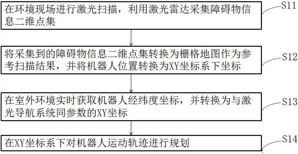
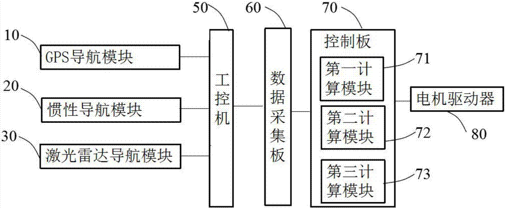
[0049] like figure 1 As shown, the present invention provides a positioning method based on multiple navigation modules, which is applied to a mobile robot. The mobile robot includes a GPS navigation module, an inertial navigation module, and a laser radar navigation module; the method includes the steps:

[0050] S1. Acquire the latitude and longitude coordinates of the mobile robot at time t-1 and time t through the GPS navigation module, and convert them to coordinate values ​​in the XY coordinate system; the inertial navigation module correspond...


PUM


Abstract

The invention discloses a positioning method and mobile robot based on multiple navigation modules. A mobile robot includes a GPS navigation module, an inertial navigation module, and a laser radar navigation module. The method includes the following steps: the GPS navigation module converting the longitude and latitude coordinates at the t-1 moment and t moment to coordinate values in an X-Y coordinate system; the inertial navigation module obtaining changes to a yaw angle of the mobile robot through signal information corresponding to the t-1 moment and the t moment; acquiring scanning data of the laser radar navigation module at the t-1 moment and t moment; obtaining the inertial navigation pose and laser pose of the mobile robot at the t moment in combination with a motion model of the mobile robot that is established in advance; fusing the inertial navigation pose and the laser pose of the mobile robot in combination with the environment road sign information, obtaining the current pose of the mobile robot at the t moment. According to the invention, no need is required for arranging any other apparatus in the field, and real-time positioning of the body of the mobile robot can be realized and the positioning precision is increased.

Description

technical field [0001] The present invention relates to the technical field of mobile robot navigation and positioning, in particular to a positioning method based on multiple navigation modules and a mobile robot. Background technique [0002] The current mobile robot navigation methods mainly include satellite navigation, laser navigation and ultrasonic navigation. A single navigation system has its own unique performance and limitations. Due to the different operating environments of the robot, the movement of the robot using a single navigation system has systematic errors in each step of the operation. The various information observed by the sensors carried by itself uses the information fusion algorithm to comprehensively eliminate the errors existing in a single navigation system, and estimate the environment map and the movement trajectory of the robot in this environment map. [0003] Patent Publication No. CN101576384 describes a method for positioning a mobile ro...

Claims


Application Information

Patent Timeline
Patent Type & Authority Applications(China)
IPC IPC(8): G01S19/48G01S19/49G01S17/06
CPCG01S19/49G01S17/06G01S19/48
Inventor 梅涛朱昕毅陈剑方健姜丽丽
Owner ANKE SMART CITY TECH PRC
Learn More