Stereo-mapping satellite-image-matching suspicious-region automatic detection method

A satellite image, three-dimensional mapping technology, applied in the field of image processing, can solve the problem of cleaning the wrong area, and achieve the effect of efficient occlusion area detection, efficient large-area water detection, efficient automatic detection and removal of thick clouds

Active Publication Date: 2017-08-29
自然资源部国土卫星遥感应用中心
View PDF4 Cites 9 Cited by
  • Summary
  • Abstract
  • Description
  • Claims
  • Application Information

AI Technical Summary

Problems solved by technology

However, for the error matching caused by factors such as large-area shadows, water areas, thick clouds, and overexposure, it is difficult to remove the error area by only relying on the consistency detection of the left and right matching results, and because the left and right matching consistency threshold is set too low. Some correct match region removal

Method used


Image

  • Stereo-mapping satellite-image-matching suspicious-region automatic detection method
  • Stereo-mapping satellite-image-matching suspicious-region automatic detection method
  • Stereo-mapping satellite-image-matching suspicious-region automatic detection method

Examples


Embodiment Construction

[0056] The present invention is described more fully hereinafter, in which exemplary embodiments of the invention are illustrated.

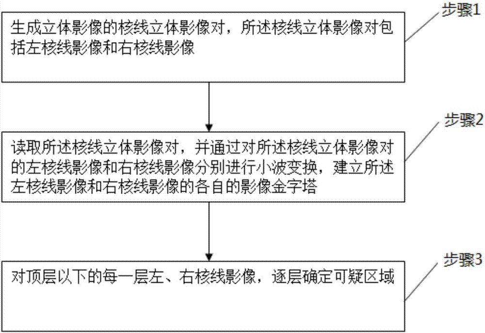
[0057] Such as figure 1 As shown, the method for automatic detection of suspicious areas in stereoscopic surveying and mapping satellite image matching proposed by the present invention includes the following steps:

[0058] Step 1, generating an epipolar stereoscopic image pair of a stereoscopic image, the epipolar stereoscopic image pair comprising a left epipolar image and a right epipolar image;

[0059] According to a preferred embodiment of the present invention, the projection trajectory method is used to generate the epipolar stereo image pair of the stereo image. Generating the epipolar stereo image pair of the stereo image by the projected trajectory method is a well-known technology in the art, and will not be repeated here.

[0060] Step 2, read the epipolar stereoscopic image pair, and respectively perform wavelet transformation on...


PUM


Abstract

The invention discloses a stereo-mapping satellite-image-matching suspicious-region automatic detection method. The method comprises the following steps of step1, generating an epipolar-line stereo image pair of a stereo image, wherein the epipolar-line stereo image pair includes a left epipolar-line image and a right epipolar-line image; step2, reading the epipolar-line stereo image pair, and carrying out wavelet transform on the left epipolar-line image and the right epipolar-line image of the epipolar-line stereo image pair respectively so as to establish image pyramids of the left epipolar-line image and the right epipolar-line image; and step3, determining suspicious regions in the left epipolar-line image and the right epipolar-line image of each layer of the image pyramids below a top layer in a layer-by-layer mode. In the invention, high-efficient thick-cloud automatic detection and rejecting can be realized; high-efficient shielding area detection, large-area water area detection and non-texture shadow area detection can be realized; and a good actual application value is possessed.

Description

technical field [0001] The invention relates to the technical field of image processing, and more specifically, to a method for automatically detecting suspicious areas in stereoscopic surveying and mapping satellite image matching. Background technique [0002] In the process of satellite and aerial stereo image matching to obtain digital surface models (digital surface model, DSM), due to the existence of factors such as large terrain slopes or occlusions, large areas of shadows, waters, thick clouds, and overexposure, some areas are matched. mistake. These error regions are often patchable in the presence of redundant observations. If these error areas can be detected automatically, the automation degree of DSM extraction under the condition of large area and multiple image redundancy will be significantly improved. [0003] Consistency detection of left and right matching results is a traditional suspicious region detection method, which has a high detection success ra...

Claims


Application Information

Patent Timeline
Patent Type & Authority Applications(China)
IPC IPC(8): G06T7/11
CPCG06T7/11G06T2207/10032G06T2207/20016
Inventor 唐新明岳庆兴高小明陈乾福陈继溢薛玉彩谢金华
Owner 自然资源部国土卫星遥感应用中心
Why Eureka
Try Eureka