Remote sensing image water body extraction method based on sub-pixel positioning

A technology for remote sensing image and water body extraction, applied in the field of remote sensing image, can solve the problems of manual determination, easy to be subject to human subjective influence, poor portability, etc. Effect

Inactive Publication Date: 2017-10-10
GUANGZHOU INST OF GEOGRAPHY GUANGDONG ACAD OF SCI
View PDF4 Cites 9 Cited by
  • Summary
  • Abstract
  • Description
  • Claims
  • Application Information

AI Technical Summary

Problems solved by technology

However, the commonly used water extraction methods based on spectral analysis are not high in the overall accuracy of small river water extraction, and these methods are related to specific applications and research areas, have poor portability, and rely on expert experience and existing reference data. The effect of extracting water bodies in complex and diverse areas on the surface is not ideal; the threshold needs to be manually determined, and the threshold needs to be determined by multiple experiments, and it is easily affected by human subjectivity
At present, the idea of ​​sub-pixel positioning has been widely used in remote sensing image classification, but for special geographical objects of water bodies, how to use the idea of ​​sub-pixel positioning that considers both the spatial correlation between pixels and the correlation between sub-pixels within a pixel , the research and application of automatically extracting sub-pixel water body information from remote sensing images are relatively few

Method used


Image

  • Remote sensing image water body extraction method based on sub-pixel positioning
  • Remote sensing image water body extraction method based on sub-pixel positioning
  • Remote sensing image water body extraction method based on sub-pixel positioning

Examples


Embodiment Construction

[0029] The present invention will be described in detail below in conjunction with the accompanying drawings and embodiments.

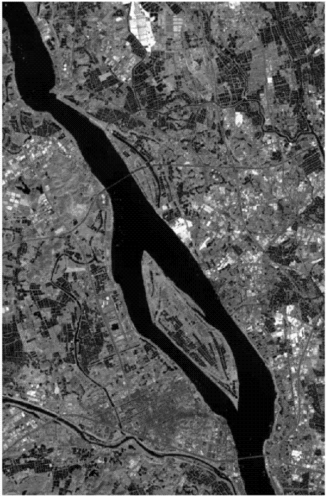
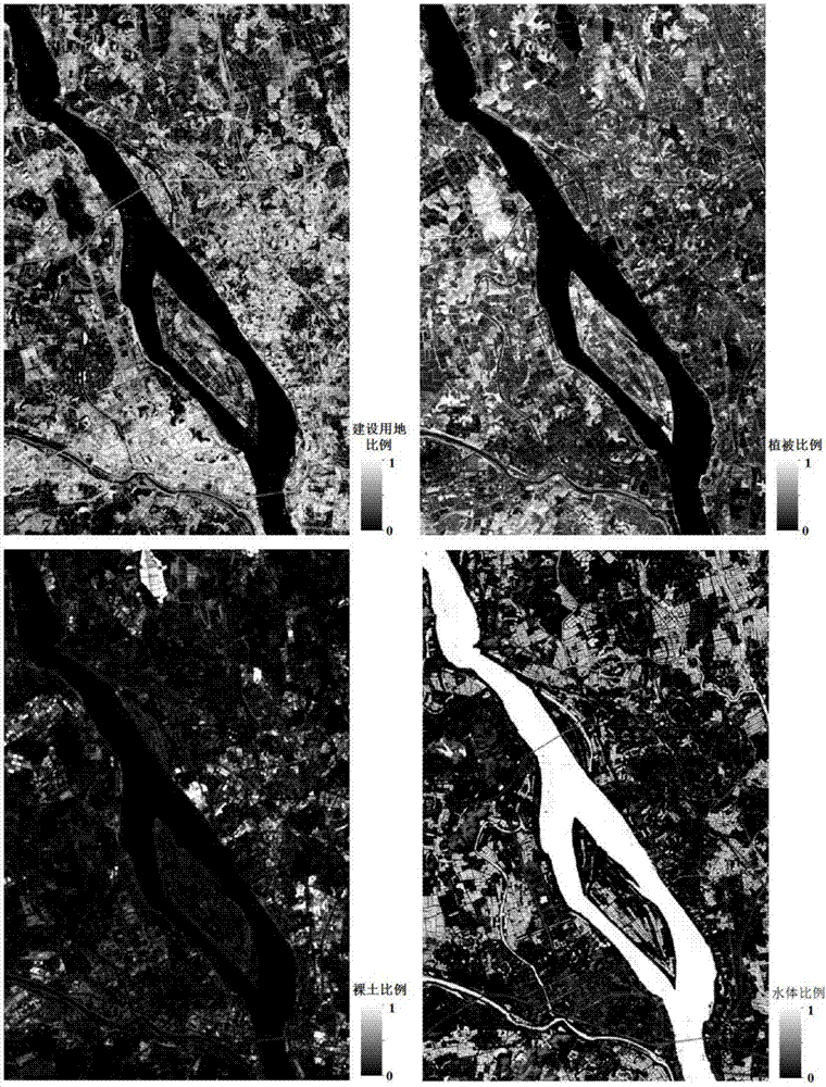
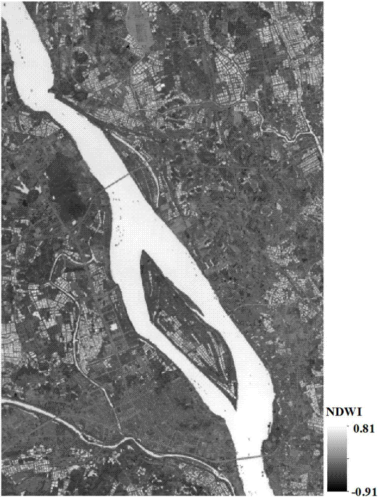
[0030] Attached figure 1 The remote sensing image shown is the river image to be extracted. The size of the image is 401 rows and 615 columns. The imaging time is October 18, 2015. The imaging sensor is Landsat 8OLI, the spatial resolution is 30 meters, and there are 9 bands in total. Using the ENVI extension tool - fully constrained least squares linear spectral unmixing tool to realize the steps of river proportion extraction; on this basis, combined with ArcGIS software, using C# programming language to realize the other 6 steps of this method under Visual Studio 2012 platform .

[0031] Step 1: Use ENVI software to preprocess the remote sensing images such as atmospheric correction and geometric correction; obtain the spectral curve through the processes of minimum noise separation transformation, pure pixel index calculation, and endmember selec...


PUM


Abstract

The invention discloses a remote sensing image water body extraction method based on sub-pixel positioning. In the method, the sub-pixel positioning thinking is introduced, which fully considers the spatial correlation of sub-pixels and the correlation of the sub-pixels inside the pixels. The method is able to perform the positioning of the water body of the optimized linear spectrum mixture dissolution result to finally obtain the water body extraction result of the sub-pixel dimensions. The method increases the accuracy for the land water body extraction algorithm, and through the sub-pixel positioning method, it is possible to obtain more refined water body structure information of the sub-pixel three dimensions from the mixed pixels, therefore, improving the precision for water body extraction. For the frequent change of the land water body size, the method of the invention provides convenience for the maintenance and updating of the water body information of the basic geographical database at various national levels.

Description

technical field [0001] The invention relates to the technical field of remote sensing images, in particular to a method for extracting water bodies from remote sensing images based on sub-pixel positioning. Background technique [0002] Water is an important material essential to the survival of all living things including human beings on the earth, and it is also a necessary natural resource for industrial and agricultural production, economic development and environmental improvement. With the rapid development of economy, urbanization and rapid increase of population, the demand for water resources has also increased sharply, the problem of water resource security has become increasingly prominent, and the world is facing severe threats to water resources. -. How to design an effective method to conduct scientific, accurate and rapid monitoring and evaluation of water bodies, grasp the information of water body changes in real time, and then adopt corresponding strategie...

Claims


Application Information

Patent Timeline
Patent Type & Authority Applications(China)
IPC IPC(8): G06K9/46G06K9/32
CPCG06V10/245G06V10/462
Inventor 刘旭拢许剑辉钟凯文张菲菲孙彩歌赵怡叶玉瑶金利霞戴健钊
Owner GUANGZHOU INST OF GEOGRAPHY GUANGDONG ACAD OF SCI
Why Eureka
Try Eureka