
Single tree segmentation method based on airborne laser point cloud aggregation relationship

An airborne laser and laser point technology, applied in image analysis, computer components, image data processing, etc., can solve problems such as information loss, wrong segmentation, inappropriate shape segmentation, etc., to reduce wrong segmentation, reduce computing time, Reduce the effect of inappropriate shape segmentation

Active Publication Date: 2017-10-20
UNIV OF ELECTRONICS SCI & TECH OF CHINA
View PDF11 Cites 31 Cited by
  • Summary
  • Abstract
  • Description
  • Claims
  • Application Information

AI Technical Summary

Problems solved by technology

When using the CHM method for single tree segmentation, since the established CHM often uses interpolation points instead of real three-dimensional space points, it will cause irreversible information loss. In addition, the custom window size is used to process the CHM. The window size and tree height It is related to the size of the crown, so when using CHM for segmentation, it often leads to wrong segmentation and inappropriate shape segmentation

Method used


Image

  • Single tree segmentation method based on airborne laser point cloud aggregation relationship
  • Single tree segmentation method based on airborne laser point cloud aggregation relationship
  • Single tree segmentation method based on airborne laser point cloud aggregation relationship

Examples


Embodiment Construction

[0041] Below by the implementation of a sample square and in conjunction with accompanying drawing the present invention is described in further detail:

[0042] The development environment is Microsoft Visual Studio 2010, the development platform framework is .Net Framework3.5, the 3D visualization engine is DirectX 11, and the programming language is C#.

[0043] Step 1. Take the Shangkuli Farm in the northwest of Hulun Buir City, Inner Mongolia and the southeast of Erguna City as the research area. The geographical location coordinates of the research area are 120°36′50.48″-120°52′56.53″ east longitude, 50° north latitude 21′11.08″~50°24′32.00″, and 30 quadrats measured in the field were selected as the verification area for single tree segmentation, and the dominant vegetation is birch. The Leica LAS60 scanning system was used to obtain the airborne lidar data in this area. The flight time was from August 16, 2012 to September 25, 2012. The specific parameters of the syste...


PUM


Abstract

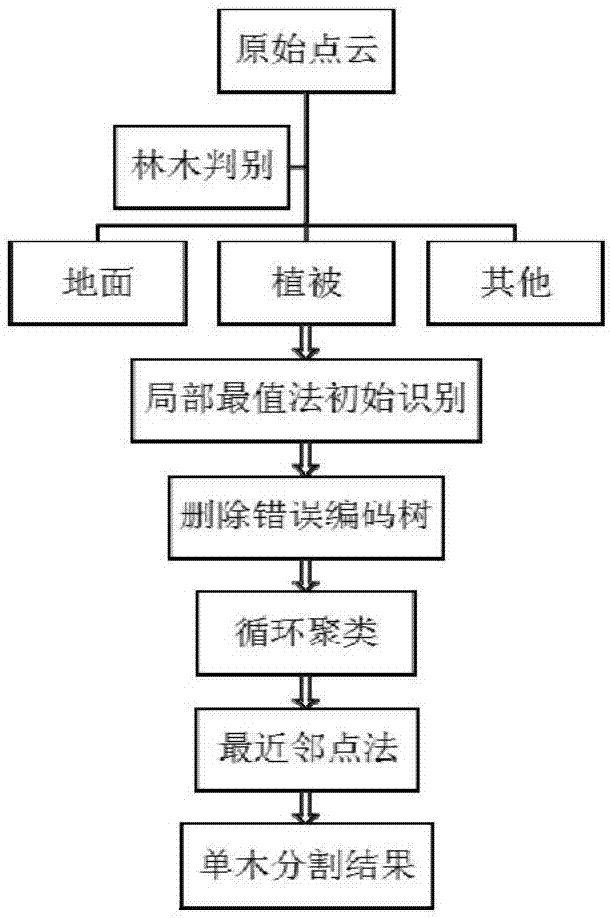
The invention belongs to the field of airborne laser radar forest remote sensing applications, and in particular relates to a single tree segmentation method based on an airborne laser point cloud aggregation relationship. According to the invention, three-dimensional laser point cloud data of the forest vegetation canopy are acquired by using an airborne laser radar, and through the forest identification, the initial segmentation by a local maximum method, the deletion of a wrongly segmented single tree, the cyclic clustering and the processing by a nearest neighbor method, a single tree image segmentation method segmenting a single tree from the forest based on the original three-dimensional laser point cloud data is established. Compared with a CHM single tree segmentation method, the method of the invention is advantageous in that the information loss can be avoided, segmentation errors and improper shape segmentation are reduced, the segmentation effect is excellent, the computation time is also greatly reduced, echo laser points belonging to a specific single tree can be quickly and accurately segmented from the forest laser point cloud data, and the parameter inversion of a single tree, the reconstruction of three-dimensional structural features of the single tree and the validation of forest vegetation parameter inversion are facilitated.

Description

technical field [0001] The invention belongs to the application field of airborne laser radar forest remote sensing, and in particular relates to a single tree segmentation method based on the aggregation relationship of airborne laser point clouds. Background technique [0002] Airborne light detection and ranging (A-LiDAR) is an effective and active remote sensing technology that measures the distance between the sensor and the target through the laser emitted by the sensor mounted on the aircraft. , quickly obtain the geometric information of the earth's surface (such as three-dimensional geographic coordinates), and the radiation information of the echo surface objects, and can be applied on a large scale, coupled with its strong ability to penetrate forest vegetation, it is a forest structure parameter The extraction and inversion of forest ecosystem function parameters provide a new technical means. [0003] In terms of forestry applications, research using airborne l...

Claims


Application Information

Patent Timeline
IPC IPC(8): G06T7/11G06K9/62
CPCG06T7/11G06T2207/30188G06T2207/10044G06T2207/10028G06F18/23213
Inventor 李世华苏练
Owner UNIV OF ELECTRONICS SCI & TECH OF CHINA
Learn More