A digital mapping method and system based on a real-world three-dimensional model
A technology of 3D model and digital mapping, which is applied in the field of digital mapping system based on real 3D model, and can solve problems such as inability to fully reflect the real scene, inability to obtain image data, and accuracy bottlenecks
- Summary
- Abstract
- Description
- Claims
- Application Information
AI Technical Summary
Problems solved by technology
Method used
Image
Examples
Embodiment Construction
[0036] In order to enable those skilled in the art to better understand the technical solution of the present invention, the present invention will be described in detail below in conjunction with the accompanying drawings. The description in this part is only exemplary and explanatory, and should not have any limiting effect on the protection scope of the present invention. .
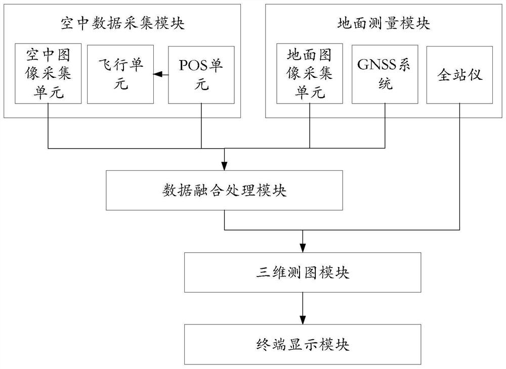
[0037] Such as image 3 As shown, a digital mapping system based on a real three-dimensional model, including an aerial data acquisition module, a ground measurement module, a data fusion processing module, and a three-dimensional mapping module;
[0038] The aerial data collection module is used to collect aerial image data according to the preset navigation route, and send the collected aerial image data and POS information to the data fusion processing module; the aerial data collection module integrates the POS system and the communication system, and the ground station After the connection is mad...
PUM
 Abstract
Description
Claims
Application Information
 - R&D
- Intellectual Property
- Life Sciences
- Materials
- Tech Scout
- Unparalleled Data Quality
- Higher Quality Content
- 60% Fewer Hallucinations
Browse by: Latest US Patents, China's latest patents, Technical Efficacy Thesaurus, Application Domain, Technology Topic, Popular Technical Reports.
© 2025 PatSnap. All rights reserved.Legal|Privacy policy|Modern Slavery Act Transparency Statement|Sitemap|About US| Contact US: help@patsnap.com


