Ground-penetrating-radar-based active fault shallow ground surface spatial distribution detection method

A ground-penetrating radar and spatial distribution technology, applied in the field of geological survey, can solve problems such as low acquisition efficiency, low detection accuracy, and surface influence

Active Publication Date: 2018-02-13
HENAN INST OF ENG
View PDF5 Cites 31 Cited by
  • Summary
  • Abstract
  • Description
  • Claims
  • Application Information

AI Technical Summary

Problems solved by technology

[0005] Aiming at the technical problems of low acquisition efficiency, low detection accuracy and great impact on the surface of the existing active fault shallow spatial structure detection method, the present invention proposes a ground-penetrating radar-based active fault shallow surface spatial distribution detection method

Method used


Image

  • Ground-penetrating-radar-based active fault shallow ground surface spatial distribution detection method
  • Ground-penetrating-radar-based active fault shallow ground surface spatial distribution detection method
  • Ground-penetrating-radar-based active fault shallow ground surface spatial distribution detection method

Examples


Embodiment Construction

[0048] The technical solutions in the embodiments of the present invention will be clearly and completely described below in conjunction with the accompanying drawings in the embodiments of the present invention. Obviously, the described embodiments are only some of the embodiments of the present invention, not all of them. Based on the embodiments of the present invention, all other embodiments obtained by persons of ordinary skill in the art without paying creative efforts belong to the protection scope of the present invention.

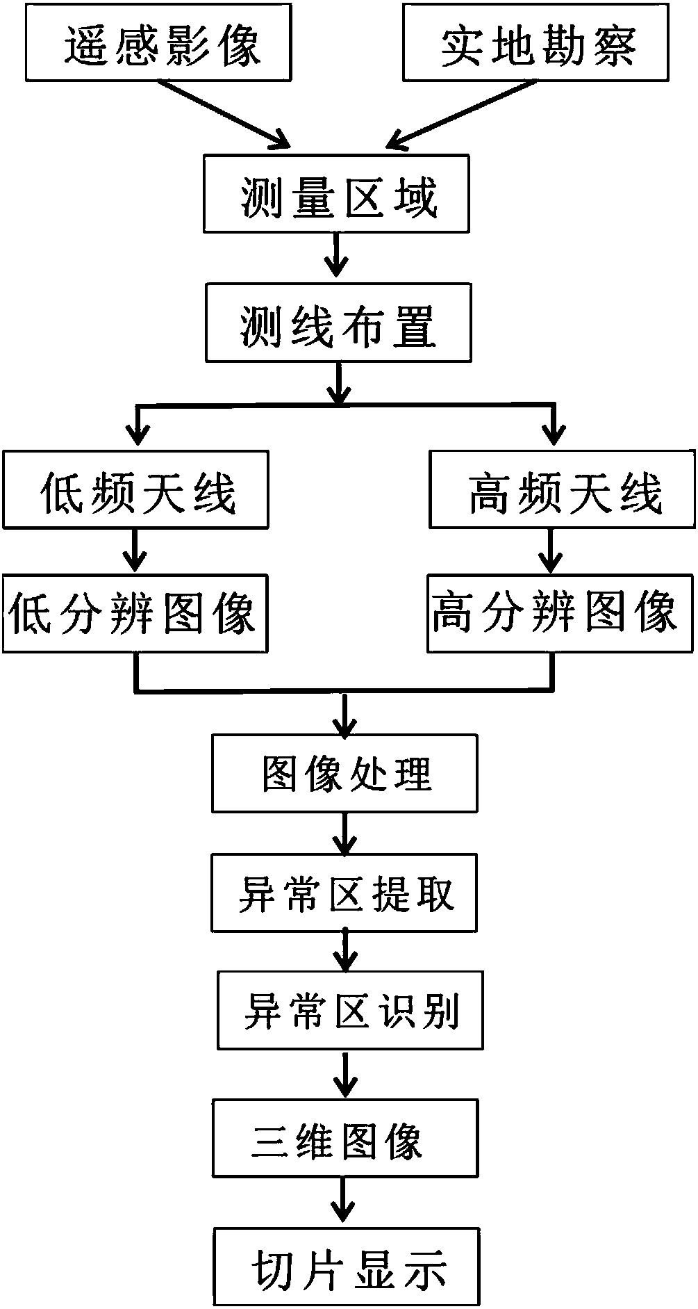
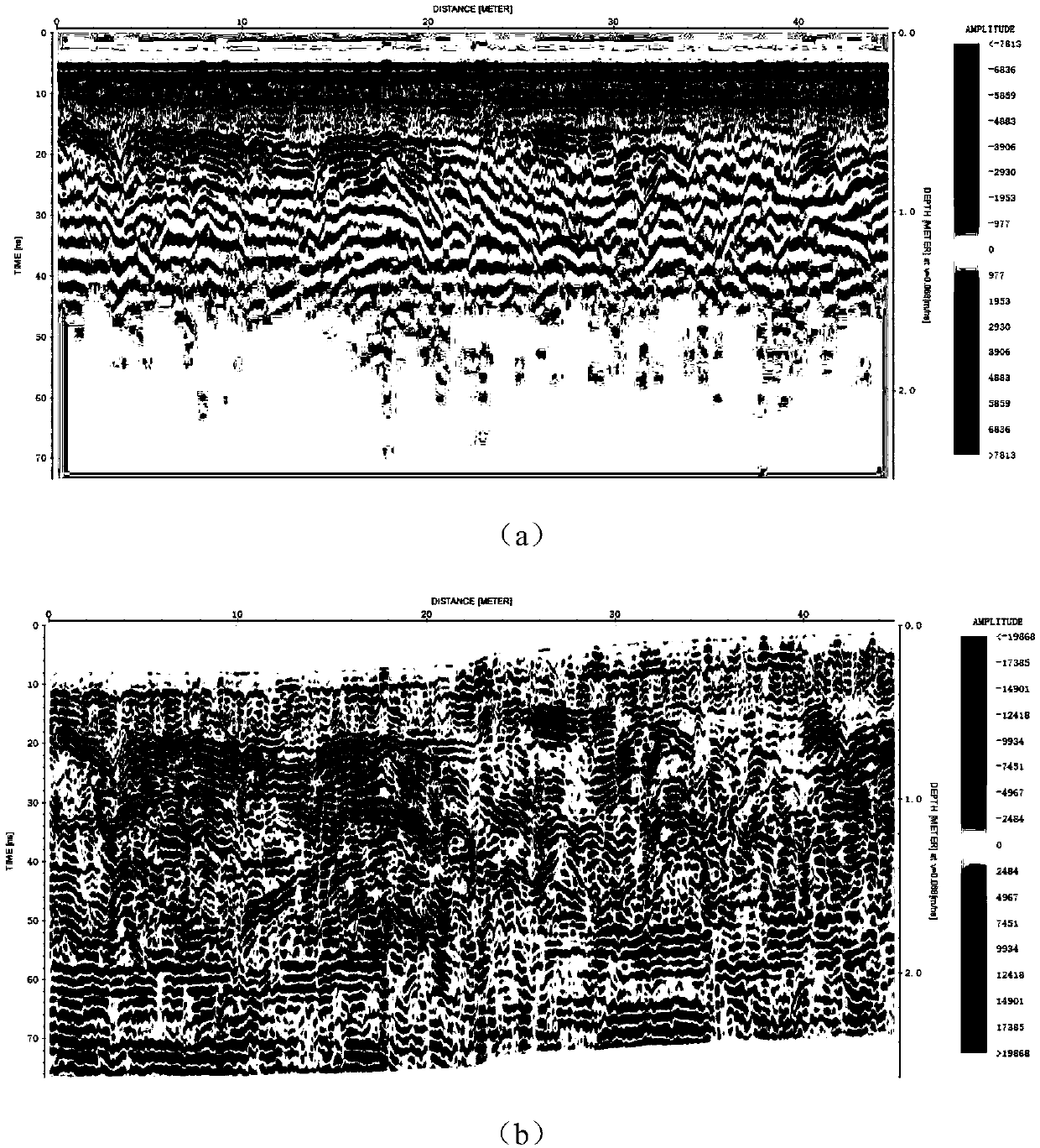
[0049] Such as figure 1 As shown, a ground-penetrating radar-based method for detecting the spatial distribution of active faults in the shallow surface layer, the steps are as follows:

[0050] Step 1: Preliminary selection of areas where active faults pass through: According to the superposition data of high-resolution remote sensing images and global digital elevation model data, through the linear marks and vertical shift marks of active faults...


PUM


Abstract

The invention relates to a ground-penetrating-radar-based active fault shallow ground surface spatial distribution detection method, and belongs to the field of geological survey. The method mainly comprises the following steps of primary election of an active fault passing region, ground-penetrating radar line layout and field data collection, ground-penetrating radar image processing and image anomaly region extraction and recognition and ground-penetrating radar image three-dimensional rebuilding and slice analysis. Accordingly, the detects that for an existing active fault shallow ground surface spatial structure detection method, the data collecting efficiency of a trial trench, an electrical prospecting apparatus, a magnetic susceptibility meter and the like is low, the resolution ratio is low, and the surface environment is destroyed are overcome, active fault detection under the complex environment can be achieved continuously in a large area, the method is easy to implement, the detection efficiency and precision are high, and the result is visual.

Description

[0001] technology neighborhood [0002] The invention relates to the technical field of geological survey, in particular to a ground-penetrating radar-based method for detecting the spatial distribution of active fault shallow surface layers. Background technique [0003] The area where the active fault zone passes is basically in the differential activity zone where the modern crustal movement is unstable, and it is easy to develop a variety of geological disasters, such as earthquakes, landslides, debris flows, etc., which will directly endanger people's lives and property, as well as the safety of urban construction and major projects. The fault occurrence process represents the process of an earthquake from seismogenesis to earthquake generation. The recorded seismic data in the world show that strong earthquakes above magnitude 7.0 basically occur on large-scale active fault zones. Research in this area is very important, not only can we fully understand the characteristi...

Claims


Application Information

Patent Timeline
Patent Type & Authority Applications(China)
IPC IPC(8): G01S13/88G01S13/89G01S7/41G01V3/12G06K9/00G06T7/00
CPCG06T7/0002G01S7/41G01S13/885G01S13/89G01V3/12G06T2207/10044G06V20/13
Inventor 张迪刘绍堂王果蒋瑞波
Owner HENAN INST OF ENG
Why Eureka
Try Eureka