Onboard laser point cloud filtering method based on cylindrical coordinates

A vehicle-mounted laser and cylindrical coordinate technology, applied in the field of lidar remote sensing mapping, can solve the problems of low filtering efficiency, uneven distribution of vehicle-mounted laser point clouds, and high point density, so as to improve filtering efficiency and avoid filtering out large-scale objects. and the effect of maintaining small-scale terrain details

A vehicle-mounted laser and cylindrical coordinate technology, applied in the field of lidar remote sensing mapping, can solve the problems of low filtering efficiency, uneven distribution of vehicle-mounted laser point clouds, and high point density, so as to improve filtering efficiency and avoid filtering out large-scale objects. and the effect of maintaining small-scale terrain details

CN107798657AActive Publication Date: 2018-03-13武汉珞珈新空科技有限公司 +1

Image

  • Onboard laser point cloud filtering method based on cylindrical coordinates
  • Onboard laser point cloud filtering method based on cylindrical coordinates
  • Onboard laser point cloud filtering method based on cylindrical coordinates

Examples


Embodiment Construction

[0023] In order to facilitate those of ordinary skill in the art to understand and implement the present invention, the present invention will be described in further detail below in conjunction with the accompanying drawings and embodiments. It should be understood that the implementation examples described here are only used to illustrate and explain the present invention, and are not intended to limit this invention.

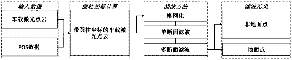
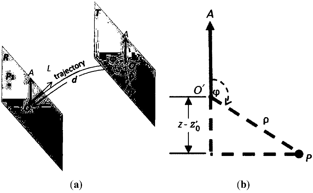
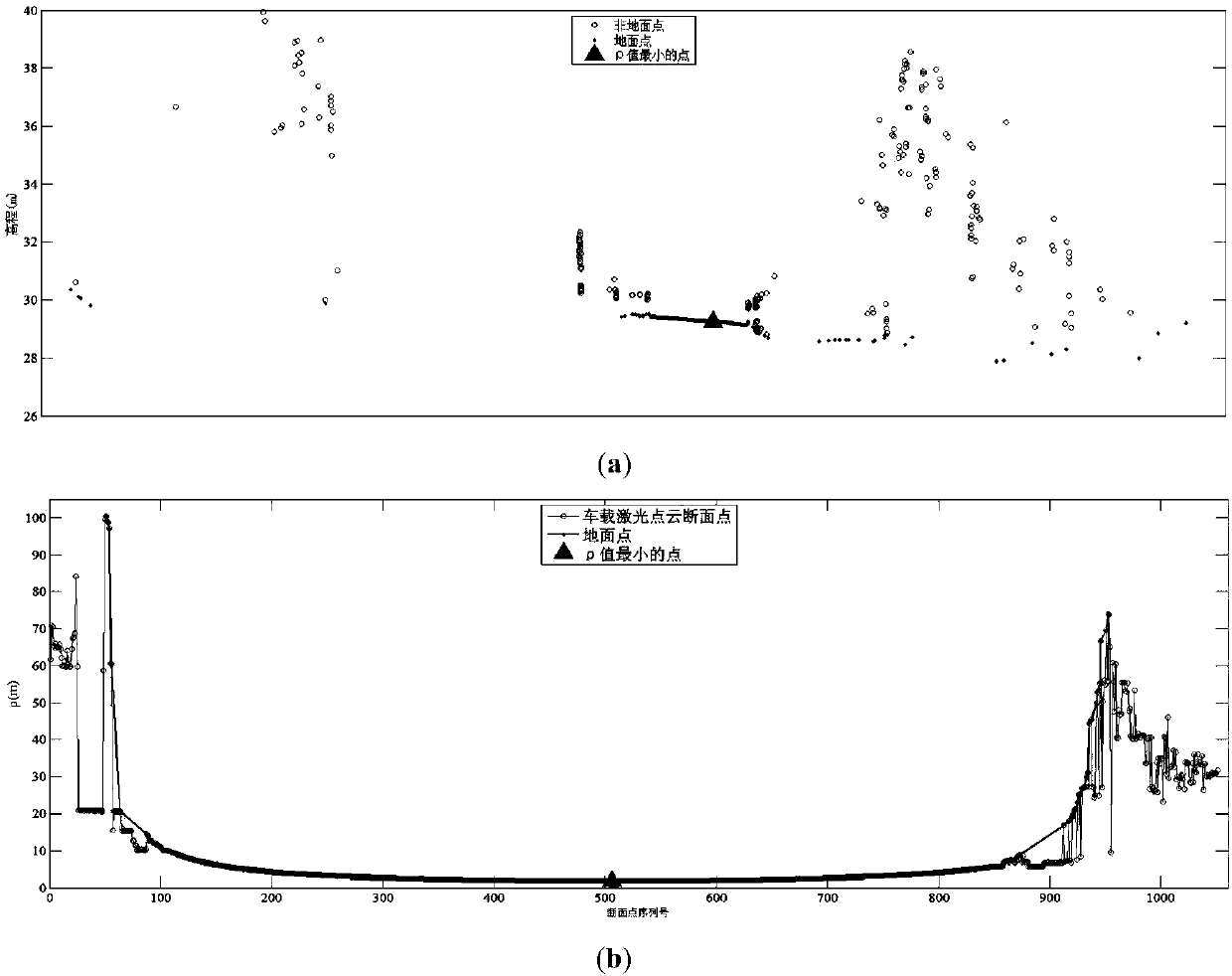
[0024] The invention provides a vehicle-mounted laser point cloud filtering algorithm. The invention fully considers the high density of the vehicle-mounted laser point cloud, the uneven distribution of point clouds, the existence of a large number of occluded areas in the point cloud, and the presence of large-scale ground objects and small-scale terrain in the point cloud. Details and other characteristics, overcome the low filtering efficiency caused by the high point cloud density in the vehicle-mounted laser point cloud filter, the data interpolation erro...


PUM


Abstract

The invention discloses an onboard laser point cloud filtering method based on cylindrical coordinates. The method comprises: firstly converting onboard laser point cloud from a Cartesian coordinate system (x, y, z) into a cylindrical coordinate system ([rho] ,[phi], d); then, in the cylindrical coordinate system, subjecting the onboard laser point cloud to grid transformation in the plane of [phi]d to form regular grids; and finally subjecting the regular grids to single-section and multi-section filtering based on distance constraint and angle constraint to obtain a final ground point. The method can solve the large point density, the uneven distribution, and a large number of occlusion areas of the onboard laser point cloud, can filter out a large number of large-scale non-ground objects in the onboard laser point cloud, and can maintain the small-scale terrain details in the onboard laser point cloud.

Description

technical field [0001] The invention belongs to the technical field of laser radar remote sensing surveying and mapping, and relates to a vehicle-mounted laser point cloud filtering method, in particular to a vehicle-mounted laser point cloud filtering method based on cylindrical coordinates. Background technique [0002] The vehicle-mounted laser scanning system integrates sensors such as laser scanner (LiDAR, Light Detection AndRanging), satellite positioning system (GNSS, Global Navigation Satellite System) and inertial navigation system (INS, Inertial Navigation System) in the mobile platform. It collects the three-dimensional spatial information and attribute information of roads and surrounding features in a medium and efficient manner, and is widely used in road surveys, road facility surveys, and lane-level high-precision map production. [0003] The vehicle-mounted laser point cloud is the main data achievement of the vehicle-mounted laser scanning system. Since th...

Claims


Application Information

Patent Timeline
13 Mar 2018
Publication
CN107798657A
IPC
G06T3/60; G06T5/00; G01S17/89
CPC
G01S17/89; G06T3/604; G06T5/00; G06T2207/10028
Inventors
刘华; 陈长军