Method for measuring antenna angle of communication tower by using drone and convolutional neural network

A technology of convolutional neural network and antenna angle, which is applied in the direction of measurement angle, neural learning method, biological neural network model, etc., can solve problems such as difficulty in determining the actual center point, large calibration error with naked eyes, and difficult long-term operations, etc., to achieve Improve measurement accuracy and efficiency, high accuracy, and reduce work difficulty

Active Publication Date: 2018-03-23
杭州艾航科技有限公司
View PDF4 Cites 27 Cited by
  • Summary
  • Abstract
  • Description
  • Claims
  • Application Information

AI Technical Summary

Problems solved by technology

[0004] Problems and shortcomings of this existing technology: Both the azimuth and the downtilt angle require the drone pilot to control the drone on the spot and judge with the naked eye to stabilize the aircraft on the vertical angle of the base station or antenna before shooting. Judgment of the center point Due to the large area on the front of the antenna, it is difficult to determine the actual center point with the naked eye in actual operation
[0005] To sum up, the disclosed technical solution of Chinese Patent Publication No. CN106454879A "A Method for Determining Wireless Base Station Work Parameters Based on UAV Aerial Photography" has high technical requirements for UAV pilots, and at the same time, the error of naked eye calibration is large. Pilots need to concentrate on hand-eye coordination during work, and it is difficult to perform long-term operations
According to practical tests, the efficiency in actual work is even lower than that of traditional manual operation on the tower

Method used


Image

  • Method for measuring antenna angle of communication tower by using drone and convolutional neural network
  • Method for measuring antenna angle of communication tower by using drone and convolutional neural network
  • Method for measuring antenna angle of communication tower by using drone and convolutional neural network

Examples


Embodiment Construction

[0039] The embodiments of the present invention will be further described below. The following examples only further illustrate the present application, and should not be construed as limiting the present application.

[0040] Such as figure 1 , figure 2 As shown, a method of measuring the antenna angle of a communication tower using a drone and a convolutional neural network includes the following steps:

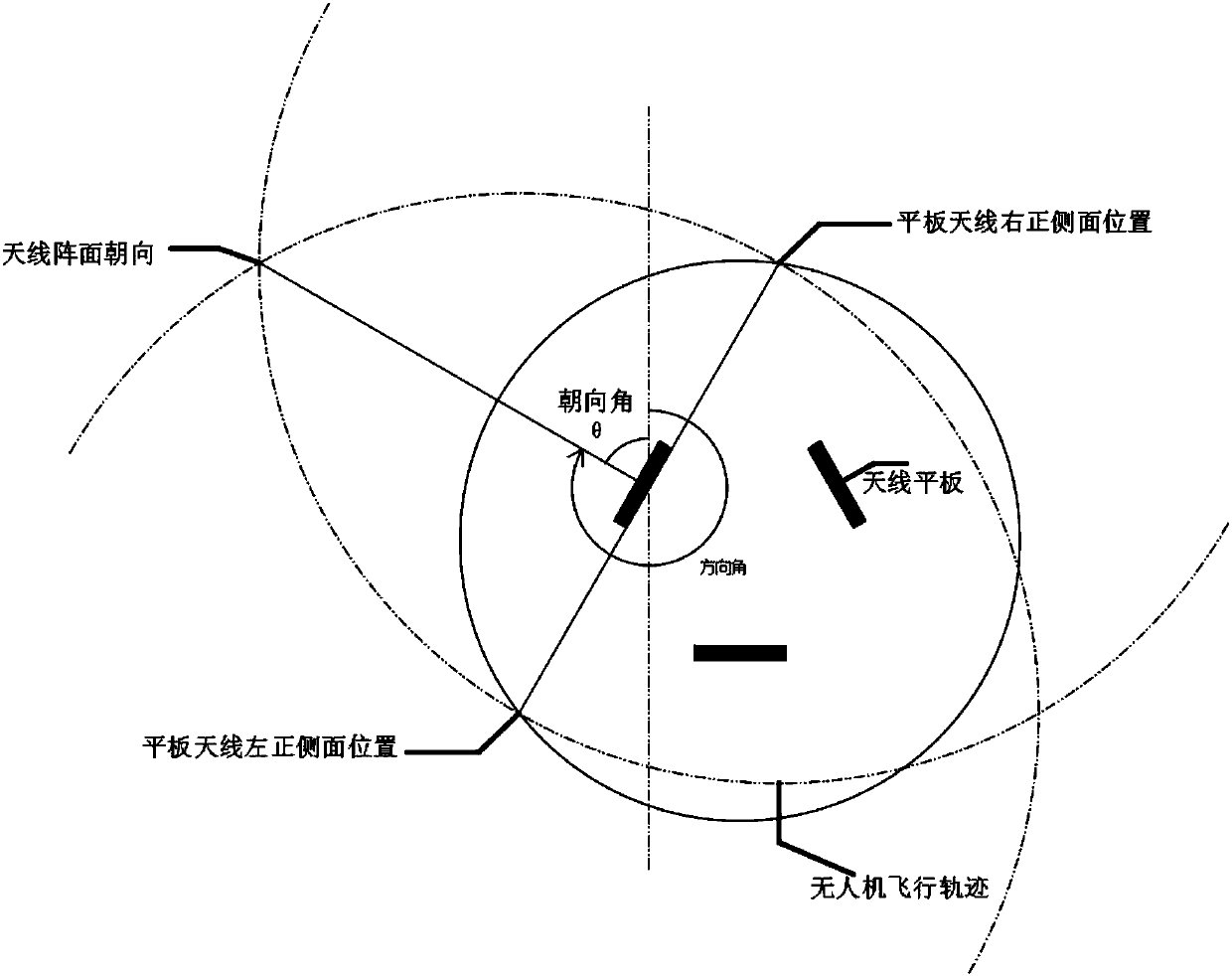
[0041] 1) Use the multi-rotor UAV to fly around the communication tower at a fixed point, continuously take pictures of the flat antenna on the communication tower and collect the GPS information of the shooting point;

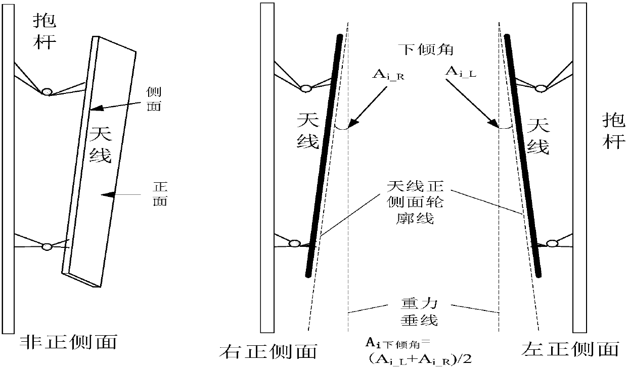
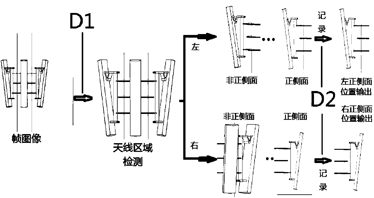
[0042] 2) Through the pre-designed and trained convolutional neural network, the antenna distribution area on both sides of the longitudinal axis of the communication tower is automatically detected, and then the image number and antenna position when the front and side of the antennas on both sides of the communication tower appear;

[0043] 3) Automat...


PUM


Abstract

The invention provides a method for measuring the antenna angle of a communication tower by using a drone and a convolutional neural network. The method comprises the following steps: allowing a multi-rotor drone to fly around the communication tower in a fixed point manner in order to continuously photograph the picture of the flat antenna on the communication tower and collect the GPS information of the photographing point; automatically detecting antenna distribution areas at two sides of the longitudinal axis of the communication tower through the convolutional neural network which is designed and trained in advance, and then detecting the image serial number and the antenna position when the front side surfaces of all the antennas at two sides of the communication tower appear; automatically pairing the images of the right front side surface and the left front side surface of the antenna detected by the convolutional neural network, wherein a left front side image pair and a rightfront side image pair can be formed by every antenna; and calculating the azimuth angle of every antenna according to the GPS information of the paired left and right front side images, and obtainingthe downtilt through calculating the average value of the downtilts of the antenna in the left and right front side images. The drone and the convolutional neural network algorithm are used to outputthe angle parameters of all the antennas, and data acquisition and data processing are separated, so the measurement accuracy and the measurement efficiency are improved, and the field work difficulty is reduced.

Description

technical field [0001] The invention relates to a method for measuring the angle of a communication tower antenna, in particular to a method for measuring the angle of a communication tower antenna by using a drone and a convolutional neural network, and belongs to the technical field of communication tower maintenance. Background technique [0002] Correct installation and maintenance testing of antennas on wireless communication base station towers is an important part of mobile communication engineering construction and operation. The traditional method uses artificial climbing towers to measure azimuth and downtilt parameters. [0003] Chinese Patent Publication No. CN106454879A "A Method for Determining the Work Parameters of a Wireless Base Station Based on UAV Aerial Photography" has disclosed a method of using UAV aerial photography to obtain a top view of the base station. The ground system calls the compass software and makes the zero degree of the compass The dir...

Claims


Application Information

Patent Timeline
Patent Type & Authority Applications(China)
IPC IPC(8): G01C11/36G01C1/00G01S19/42G06T7/00G06T7/62G06T7/73G06N3/08
CPCG01C1/00G01C11/00G01S19/42G06T7/0004G06T2207/10004G06T2207/20081G06T2207/20084G06T2207/30164G06T7/62G06T7/73G01C11/36
Inventor 潘晨周永霞
Owner 杭州艾航科技有限公司
Why Eureka
Try Eureka