Road network correction-based hybrid indoor positioning method

A positioning method and indoor positioning technology, which can be used in services based on location information, services based on specific environments, structured data retrieval, etc. impact, improve efficiency

Inactive Publication Date: 2018-04-13
星际空间(天津)科技发展有限公司
View PDF7 Cites 11 Cited by
  • Summary
  • Abstract
  • Description
  • Claims
  • Application Information

AI Technical Summary

Problems solved by technology

[0004] However, the above distance calculation formula is more accurate at short distances. When the distance becomes farther, due to the multipath effect of electromagnetic waves, signal interference, and object occlusion, the accuracy of the calculated distance will decrease, resulting in low positioning accuracy.

Method used


Image

  • Road network correction-based hybrid indoor positioning method
  • Road network correction-based hybrid indoor positioning method
  • Road network correction-based hybrid indoor positioning method

Examples


Embodiment 1

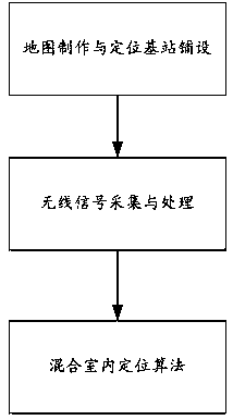
[0084] figure 1 A schematic flowchart of the mixed indoor positioning method based on road network correction provided in this embodiment, as shown in figure 1 As shown, a hybrid indoor positioning method based on road network correction, the method includes the following steps:

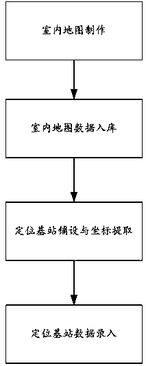
[0085] Map making and positioning base station laying: make indoor maps for the indoor positioning area, save the completed indoor map data to the spatial database; lay positioning sensors in the indoor positioning area, and extract positioning sensor coordinate data based on the indoor map data in the spatial database , saved together with the positioning base station information;

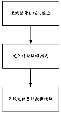
[0086] Wireless signal collection and processing: The wireless signal transmitted by the positioning terminal is filtered to perform noise processing. According to the filtered wireless signal data, the area where the positioning terminal is located is determined. According to the area judgment result, the wireless sign...


PUM


Abstract

The invention discloses a road network correction-based hybrid indoor positioning method and belongs to the indoor positioning field. The method of the invention includes the following steps of: map production and positioning base station laying; wireless signal acquisition and processing; and hybrid indoor positioning algorithm operation. The method of the present invention supports various wireless sensor signals including Bluetooth, Wi-Fi, UWB, RFID and the like; a wireless signal filtering and area determination method is adopted, and therefore, irrelevant signals can be further eliminated, and the influence of environmental factors on positioning results can be reduced; an indoor map data-based positioning correction method is adopted, so that indoor positioning accuracy can be further improved; and a positioning calculation structure based on a positioning base station and a spatial database is adopted, so that the efficiency of positioning calculation can be further improved.

Description

technical field [0001] The present invention relates to the field of indoor positioning, in particular to a positioning correction method based on indoor map data for receiving multi-sensor signals, and adopts a hybrid indoor positioning method based on road network correction based on a positioning calculation structure based on positioning base stations and spatial databases. Background technique [0002] The traditional positioning technology is mainly applicable to open outdoor locations, using positioning systems established by geostationary satellites for positioning, such as the Global Positioning System (Global Positioning System, usually referred to as GPS) and the Beidou system. [0003] However, with the development of the city, the scale of the building is getting larger and larger, and people's demand for indoor positioning is increasing. However, the indoor reception of satellite signals is poor, and the satellite positioning system cannot be used. To solve thi...

Claims


Application Information

Patent Timeline
Patent Type & Authority Applications(China)
IPC IPC(8): H04W4/02H04W4/33H04W64/00G06F17/30
CPCG06F16/29H04W64/00
Inventor 翟婧彭福国徐亚丽刘森
Owner 星际空间(天津)科技发展有限公司
Why Eureka
Try Eureka