iBeacon-assisted geomagnetic indoor real scene navigation method

A navigation method and geomagnetic technology, which is applied in ground navigation, navigation, surveying and navigation, etc., can solve the problems of poor positioning robustness and large fluctuations in received signal strength values, achieve good robustness, improve positioning accuracy, and be easy to deploy Effect

Inactive Publication Date: 2018-06-05
BEIJING UNIV OF TECH
View PDF10 Cites 17 Cited by
  • Summary
  • Abstract
  • Description
  • Claims
  • Application Information

AI Technical Summary

Problems solved by technology

The advantage is simple and reliable, the disadvantage is that the received si

Method used


Image

  • iBeacon-assisted geomagnetic indoor real scene navigation method
  • iBeacon-assisted geomagnetic indoor real scene navigation method
  • iBeacon-assisted geomagnetic indoor real scene navigation method

Examples


Embodiment 1

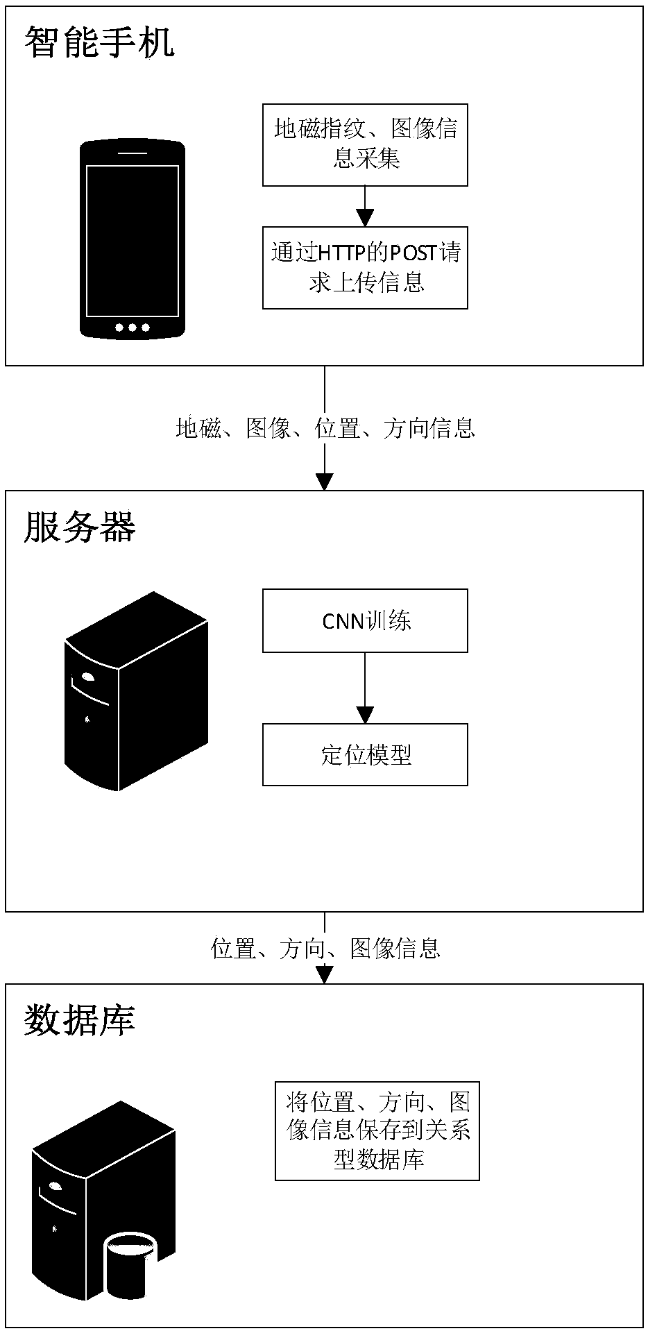
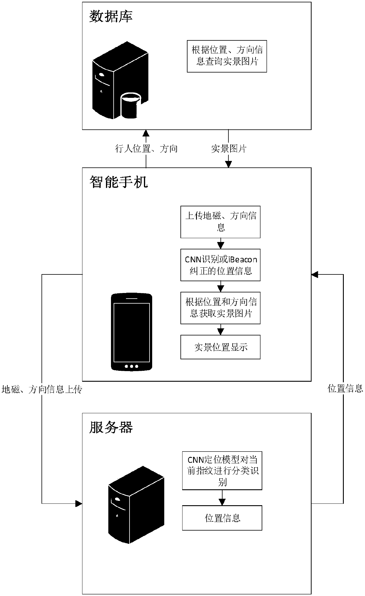
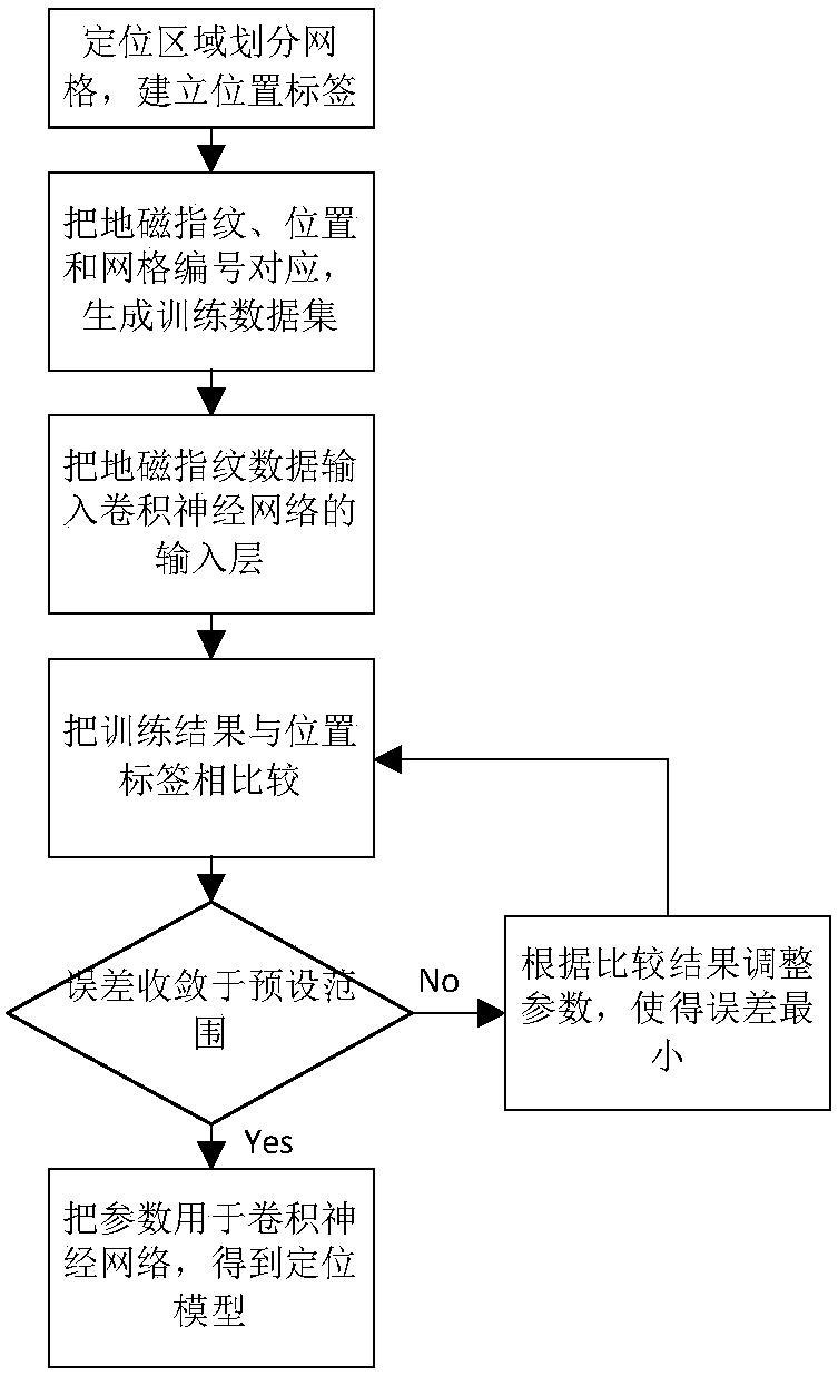
[0043] The present invention provides an iBeacon-assisted geomagnetic indoor real scene navigation method, comprising the following steps:

[0044] Step 1: Use the magnetometer of the smart phone to collect the three-dimensional geomagnetic fingerprint vector (B fx ,B fy ,B fz ), using the smartphone camera and direction sensor to collect images and direction information at different locations, and record the two-dimensional geographic location information (x, y) corresponding to the above information;

[0045] Among them, the direction information is represented by angle, for example, 0 degrees represents pedestrians facing north, 90 degrees represents pedestrians facing east, 180 degrees represents pedestrians facing south, and 270 degrees represents pedestrians facing west.

[0046] The image information is the indoor image information of pedestrians in a certain direction in a certain position in the positioning area.

[0047] In order to eliminate the influence of devi...


PUM


Abstract

The invention discloses an iBeacon-assisted geomagnetic indoor real scene navigation method. In an offline stage, a smartphone is utilized for acquiring a geomagnetic fingerprint in a position area, and a server side utilizes a convolutional neural network (CNN) algorithm in depth learning for training the acquired fingerprint data. In an online stage, a client uploads the currently acquired geomagnetic fingerprint to a server, and the server side utilizes a CNN training model for classifying and identifying fingerprint information, so that location information of the current user is obtained;meanwhile, an iBeacon base station is deployed in an indoor complex terrain place for correcting geomagnetic navigation, and Kalman filtering is carried out on an iBeacon assistant positioning signal, so that the fluctuation problem of the positioning signal is solved; and finally, the client acquires a real scene picture of a corresponding position from a database at the server side through position and orientation information, and then real scene navigation is realized.

Description

technical field [0001] The invention belongs to the field of indoor positioning, and in particular relates to an iBeacon-assisted geomagnetic indoor real-scene navigation method. Background technique [0002] At present, with the advent of the mobile Internet era, the demand for positioning in the indoor environment is increasing, and the use of smart phone terminals for accurate indoor positioning has become a research hotspot. Since GPS signals are blocked by buildings and cannot be used in indoor environments, various positioning methods have been proposed one after another. Common indoor positioning methods include: ultrasonic positioning technology, Wi-Fi fingerprint technology, inertial sensor positioning technology, etc. [0003] Ultrasonic positioning technology adopts the principle of triangular distance measurement for positioning, and has high positioning accuracy, but the disadvantage is that it is easily affected by multipath effects, and requires a large amoun...

Claims


Application Information

Patent Timeline
IPC IPC(8): G01C21/08G01C21/20G01S5/02G01S5/06G01C21/00G01S5/00G01C25/00H04W64/00G06N3/04
CPCH04W64/00H04W64/003G01C21/005G01C21/08G01C21/206G01C25/00G01S5/0045G01S5/0257G01S5/0294G01S5/06G06N3/045
Inventor 黎海涛张俊峰
Owner BEIJING UNIV OF TECH
Why Eureka
Try Eureka