System and method for meteorological information-assisted satellite imaging task planning

A technology for mission planning and satellite assistance, applied in the field of satellite applications, can solve the problems of waste of satellite resources, limited imaging resources, and poor transparency of dense stratus clouds, achieving the effects of convenient calculation, improved visibility and data availability

Inactive Publication Date: 2018-07-06
SPACE STAR TECH CO LTD
View PDF3 Cites 30 Cited by
  • Summary
  • Abstract
  • Description
  • Claims
  • Application Information

AI Technical Summary

Problems solved by technology

The general problems faced by satellite imaging are: high cost, limited star source, and very limited imageable resources
Using the traditional remote sensing satellite imaging mission planning algorithm meets the constraints of satellite platforms and payloads; however, meteorological statistics show that cloudy days (stratus) are defined as cloud cover exceeding...

Method used


Image

  • System and method for meteorological information-assisted satellite imaging task planning
  • System and method for meteorological information-assisted satellite imaging task planning
  • System and method for meteorological information-assisted satellite imaging task planning

Examples


Embodiment Construction

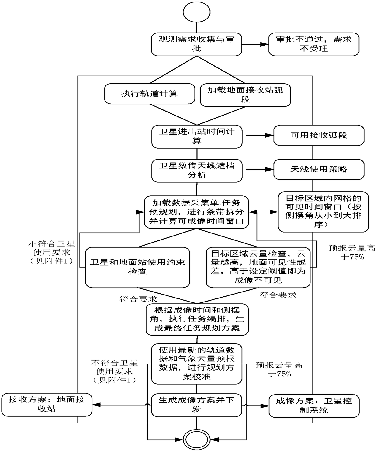
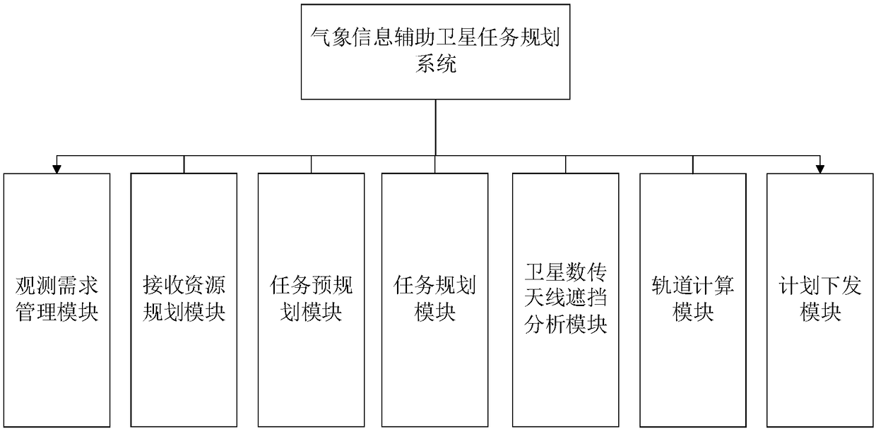
[0031] In traditional satellite imaging planning, the cloud forecast data is introduced into the mission planning, and the cloud constraint check is performed during the mission planning. It is not necessary to shoot the schemes exceeding the cloud threshold, which avoids the root cause of the poor imaging effect of remote sensing satellites. situation, improving the availability of satellite imagery.

[0032] The object of the present invention is achieved through the following technical solutions, and the detailed steps are as follows:

[0033] like figure 1 As shown, an autonomous integrity monitoring method suitable for spaceborne navigation receivers is characterized in that: it specifically includes the following steps:

[0034] Step 1. Collect observation requirements and approve the collected observation requirements;

[0035] Step 2, perform orbit calculation, respectively calculate satellite ephemeris, sub-satellite point, and astronomical time in a certain period ...


PUM


Abstract

The invention discloses a system and a method for the meteorological information-assisted satellite imaging task planning. The method comprises the steps of 1, collecting observation requirements; 2,performing imaging task treatment on an observation target; (wherein the target region divided into small regions of 10 * 10 degrees by dividing longitude and latitude grids in the global range according to a cone projection mode during the task planning process; and the divided small regions are subjected to matching and judging during the cloud cover judgment) 3, performing cloud cover inspection for each imaging scheme (based on a statistical threshold value of 75%), removing pre-arranged plans which do not meet the cloud cover constraint condition, screening out a plan set which most meetsan optimal strategy, arranging plans according to the imaging time and the imaging angle, and generating a final planning scheme; 4, respectively transmitting the information of an imaging scheme and a receiving scheme to a satellite and a ground receiving station. According to the scheme, the cloud cover in each target imaging region can be evaluated before satellite imaging, so that the imaging quality can be obviously improved.

Description

technical field [0001] The invention belongs to the field of satellite applications, and in particular relates to a system and method suitable for meteorological information-assisted satellite imaging task planning. Background technique [0002] With the rapid development and diversification of satellite application fields, the service demand for remote sensing satellite imaging applications is also increasing. Usually, the constraints of the satellite platform and its payload capabilities, such as satellite pitch maneuverability, satellite perturbation, and camera performance, will directly affect whether the satellite can be imaged, and will be considered in mission planning, while cloud cover will directly affect the quality of satellite imaging. This important factor is not considered in the planning of imaging missions in China. [0003] Taking the PRSS-1 panchromatic multi-spectral remote sensing satellite as an example, the characteristics of the mission planning sys...

Claims


Application Information

Patent Timeline
IPC IPC(8): G06Q10/10G01W1/00
CPCG06Q10/103G01W1/00B64G1/1021G06Q10/04G06Q10/06
Inventor 侯叶叶方舟陈元伟齐昕浒李媛博宇春娟
Owner SPACE STAR TECH CO LTD
Why Eureka
Try Eureka