Wetland bank slope plant ecological system for control of coal mining subsidence area

An ecosystem and construction method technology, applied in botany equipment and methods, land preparation methods, plant cultivation, etc., can solve problems such as unsightly appearance, poor ecological coordination, insufficient attention to bank slopes in coal mining subsidence areas, etc., and achieve faster environmental protection. , Accelerate the improvement and reduce the effect of soil erosion

Pending Publication Date: 2018-07-20
CHINA UNIV OF GEOSCIENCES (WUHAN)
View PDF3 Cites 4 Cited by
  • Summary
  • Abstract
  • Description
  • Claims
  • Application Information

AI Technical Summary

Problems solved by technology

Insufficient attention is paid to the bank slope in the coal mining subsidence area, and concrete slope prot

Method used


Image

  • Wetland bank slope plant ecological system for control of coal mining subsidence area
  • Wetland bank slope plant ecological system for control of coal mining subsidence area
  • Wetland bank slope plant ecological system for control of coal mining subsidence area

Examples


Embodiment 1

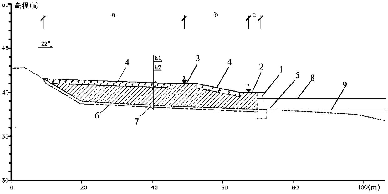
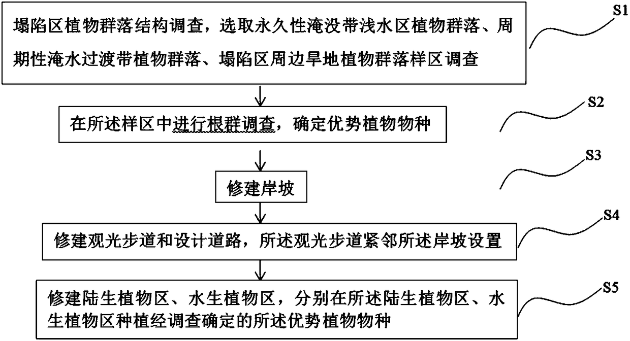
[0031] Refer to attached figure 1 A wetland bank slope plant ecosystem for controlling the coal mining subsidence area, comprising a bank slope 1, a sightseeing trail 2, a design road 3, a terrestrial plant area 4, and an aquatic plant area 5; the bank slope 1 is a gabion retaining wall structure, the soil foundation in the subsidence area is unstable, and the gabion retaining wall structure is a flexible protective structure, which can adapt to the uneven settlement of the soil in the subsidence area and ensure the stability of the bank slope 1; the sightseeing trail 2 Set up next to the bank slope 1, the height Y of the sightseeing trail 2 is 40m, which is the same as the height of the bank slope 1, and the total width c of the half of the width of the bank slope 1 and the sightseeing trail 2 is 3.15m, which is convenient for pedestrians Watching the scenery; the design road 3 and the sightseeing trail 2 are set apart from the terrestrial plant area 4, the height X of the de...

Embodiment 2

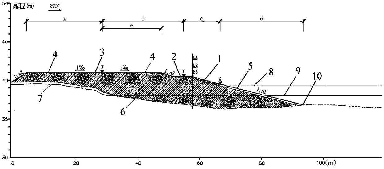
[0045] Refer to attached image 3 A wetland bank slope plant ecosystem for controlling the coal mining subsidence area, comprising a bank slope 1, a sightseeing trail 2, a design road 3, a terrestrial plant area 4, and an aquatic plant area 5; the bank slope 1 is the artificial grading structure.

[0046] Further, the slope of the bank slope 1 is 1:n 1 , n 1 is 10; the bank slope 1 includes the part located in the shallow water area of ​​the collapsed lake and the land part adjacent to the shallow water area; the land part adjacent to the shallow water area is filled with thick planting soil, thick Filling soil, thick coal gangue, the thickness h of the thick planting soil 1 is 0.2m, the said thick fill h 2 is 2.26, the thick gangue h 3 It is 1.24m; the shallow water part includes upper and lower layers, the coal gangue layer is filled below the average water level line 9 in the dry season, and the backfill soil is filled above.

[0047] Further, the width c from the mid...

Embodiment 3

[0058] The wetland in Zoucheng coal mining subsidence area is formed by the surface subsidence caused by the mining of underground coal resources in the area. Water accumulates in low-lying areas to form lakes and swamps, which are collectively called wetlands. The cultivated land around the wetlands has been seriously reduced or even completely lost production, and the houses have been severely cracked, making many houses uninhabitable due to damage; power transmission equipment, roads, railways and river embankments have also been affected to varying degrees. The geological environment of the mine has been greatly damaged, and the lives and properties of the people have been greatly threatened.

[0059] Refer to attached Figure 4 A wetland bank slope plant ecosystem and construction method for controlling the coal mining subsidence area of ​​the first embodiment of the present invention is used to construct a wetland bank slope plant ecosystem for controlling the coal minin...


PUM

PropertyMeasurementUnit
Particle sizeaaaaaaaaaa
Thicknessaaaaaaaaaa
Thicknessaaaaaaaaaa

Abstract

The invention discloses a wetland bank slope plant ecological system for control of a coal mining subsidence area and a construction method. The wetland bank slope plant ecological system comprises abank slope, a sightseeing footpath, a designed road, a terrestrial plant area and an aquatic plant area. The bank slope is of a shoreside gabion retaining wall structure or an artificial step-slope structure. The gabion retaining wall structure belongs to the flexible shoring structure and can effectively adapt to differential settlement of a soil body and reduce soil and water loss. Soil is refilled back to the underground or underwater environment of the terrestrial plant area and the aquatic plant area according to a root mass study, an original soil sectional structure is retained, and theunderground or underwater environment of the subsidence area is reconstructed. Corresponding original dominant plants are planted according to the plant community structure investigation, a various plant mixed stable community is created, the stable wetland bank slope plant ecological system for control of the coal mining subsidence area is established, and environmental improvement of the subsidence area is accelerated. Sightseeing and traffic of the subsidence area are both considered through the sightseeing footpath and the designed road.

Description

technical field [0001] The invention belongs to the technical field of environmental protection, and in particular relates to a wetland bank slope plant ecosystem and a construction method for controlling coal mining subsidence areas. Background technique [0002] Problems such as ground subsidence, ground fissures, water and soil pollution, landform landscape damage, aquifer damage, land resource damage, infrastructure slope damage, and ecological environment damage caused by coal mining are common in coal mining subsidence areas, seriously damaging human resources. The living environment restricts social and economic development. Our country has a lot of people and little land, and the land resources are extremely precious. Most of the coal mines are located under the cultivated land and forest land, and the coal mining subsidence directly leads to the destruction of the cultivated land and forest land. The destruction of a large amount of high-quality cultivated land has...

Claims


Application Information

Patent Timeline
IPC IPC(8): E02B3/00A01G22/00A01G17/00A01K61/10A01B79/02
CPCA01B79/02A01G17/005A01K61/10E02B3/00Y02A40/81Y02P60/20
Inventor 周建伟袁磊温冰郑晓明王永辉张黎明
Owner CHINA UNIV OF GEOSCIENCES (WUHAN)
Why Eureka
Try Eureka