
Passive location method for underwater moving node based on Beidou beacons and system

A mobile node and beacon node technology, applied in satellite radio beacon positioning system, radio wave measurement system, positioning, etc., can solve problems such as poor concealment of underwater targets, increased power consumption, and limitation of the number of underwater nodes

Active Publication Date: 2018-07-20
ZHEJIANG UNIV
View PDF5 Cites 27 Cited by
  • Summary
  • Abstract
  • Description
  • Claims
  • Application Information

AI Technical Summary

Problems solved by technology

Among the existing positioning systems based on sea surface beacon nodes, after retrieval, a system and method for underwater positioning disclosed in US Patent No. US7512036B2 and a method for expanding GPS underwater applications disclosed in US Patent No. US5119341, both The limitation lies in assuming that the time synchronization between the sea surface beacon node and the underwater target node does not take into account the offset problem of the underwater node clock, resulting in an increase in positioning error; Chinese patent application number CN200310118440 discloses a high The underwater GPS positioning and navigation system and method with stable frequency standards and the Chinese patent application number 201210065951 disclose a GNSS satellite-based underwater vehicle positioning method and system. The synchronization problem with the target node cannot be maintained all the time, that is, the underwater node needs to send a request positioning signal to interact with the sea surface positioning beacon
However, two-way ranging will lead to poor concealment of underwater targets, increased power consumption, and will limit the number of underwater nodes for positioning; Chinese patent application number 201410073253 discloses an underwater positioning and navigation system based on DGPS buoys and method, the limitation is that the system assumes that there is a fixed time difference between the beacon node and the target node by default, and does not consider the frequency offset and phase offset of the clock of the underwater target.
In addition, none of the above systems considered the bending of the underwater sound propagation path
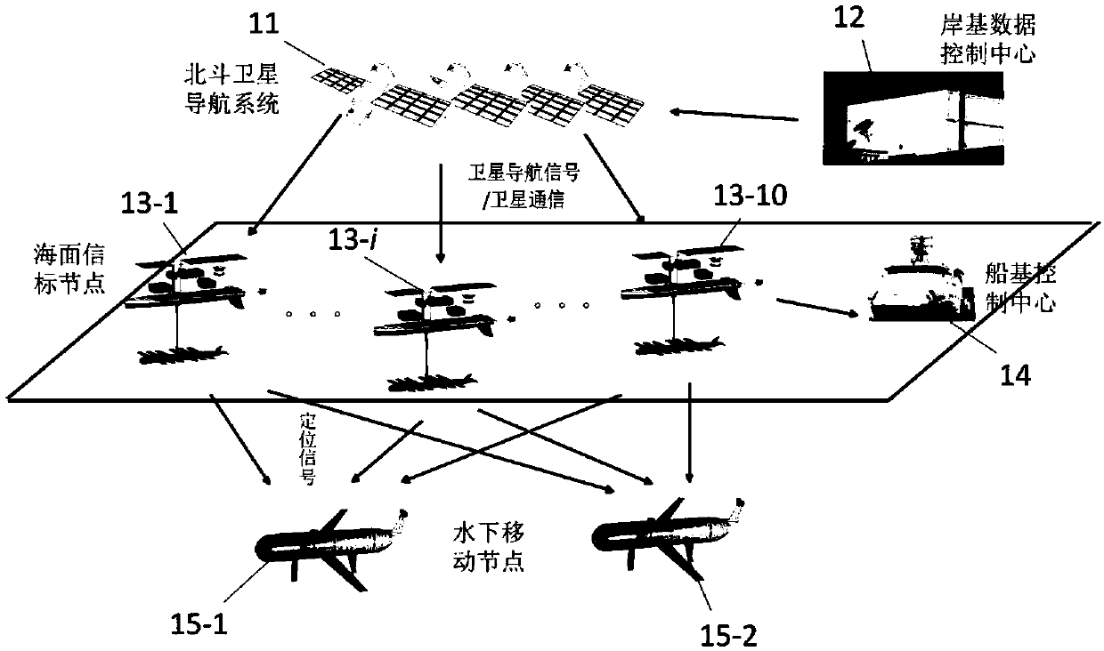
[0007] The technical problem to be solved by the present invention is to realize the passive autonomous positioning of the underwater mobile node under the condition that the clock synchronization between the sea surface beacon node and the underwater mobile node cannot be guaranteed, and the response mechanism is not used for distance measurement.

Method used


Image

  • Passive location method for underwater moving node based on Beidou beacons and system
  • Passive location method for underwater moving node based on Beidou beacons and system
  • Passive location method for underwater moving node based on Beidou beacons and system

Examples


Embodiment Construction

[0090] In order to explain the invention in more detail, it is intended to be illustrated in conjunction with the accompanying drawings, but is not limited to the accompanying drawings, where the structure in the accompanying drawings is omitted or the scale does not conform to the actual size, only for further explanation Refer to use.

[0091] A method for passive positioning of underwater mobile nodes based on Beidou beacons, comprising the following steps:

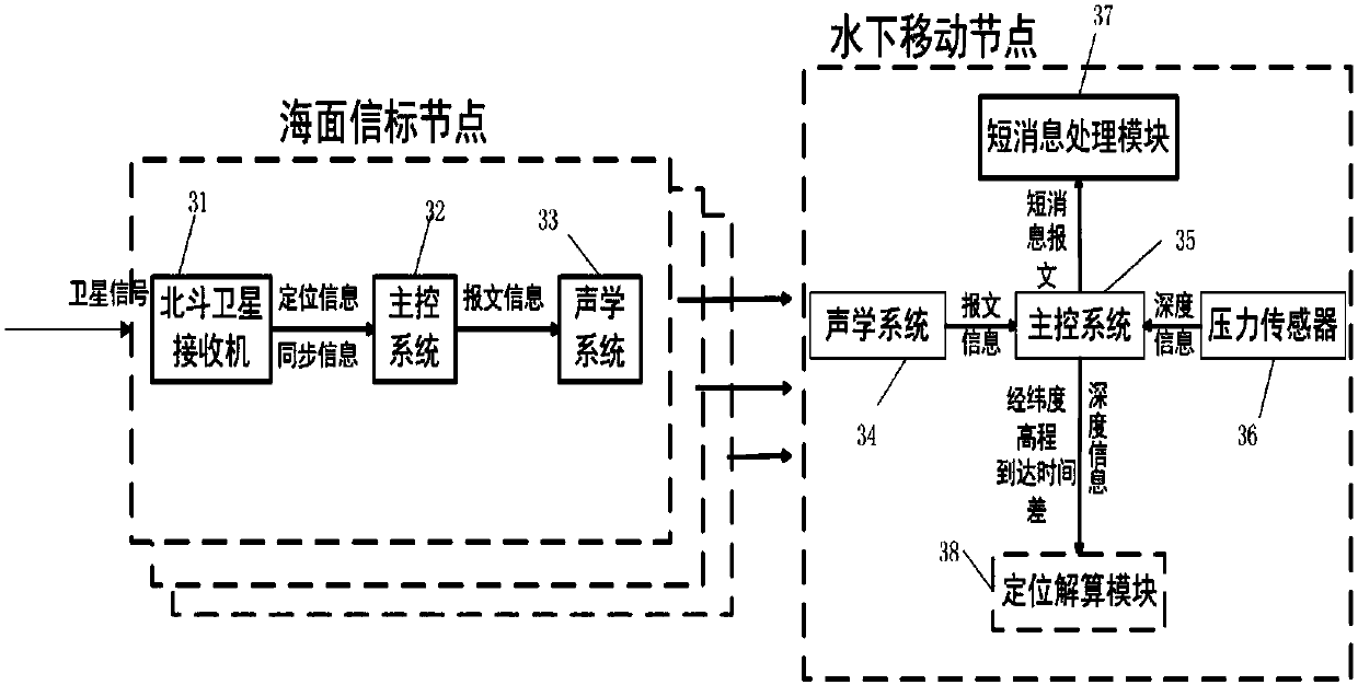
[0092] 1. The Beidou satellite receiver on the sea surface beacon node receives the positioning and navigation signal broadcast by the Beidou satellite navigation system, analyzes the longitude, latitude and elevation of the location of the sea surface beacon Beidou satellite antenna in real time, and transmits it to the sea surface beacon node. Main control system, and calibrate the main control system clock and Beidou reference time to maintain synchronization, that is, to maintain synchronization between all sea sur...


PUM


Abstract

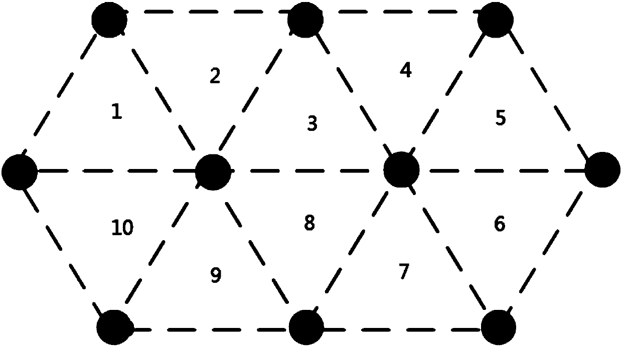
The invention relates to a passive location method for an underwater moving node based on Beidou beacons, which comprises the steps that 1, a sea surface beacon node receives a location and navigationsignal broadcast by a Beidou satellite navigation system, updates the position in real time and keep pace with the Beidou clock; three sea surface beacons located at vertexes of a triangular grid combine information such as the position and serial number into location messages and broadcast the location messages to the underwater moving node at the same time according to a time sequence table oftransmitting the location messages; and 2, if the underwater moving node receives the location messages, the position of the underwater moving node at the current moment is calculated by using a filtering algorithm according to the arrival time and message content of the three location messages, and if the underwater moving node does not receive the location messages, the position of the underwater moving node at the current moment can also calculated by using the filtering algorithm. The invention further relates to a system used for implementing the passive location method.

Description

technical field [0001] The present invention relates to a passive positioning method and system for underwater mobile nodes, in particular to the use of the Beidou satellite positioning and navigation system to realize the positioning of sea surface beacon nodes, and to realize the passive positioning of underwater mobile nodes based on the positioning signals of multiple sea surface beacon nodes methods and systems. Background technique [0002] As humans increasingly carry out marine activities, such as marine resource exploration, disaster prevention and warning, and ocean warfare, underwater unmanned equipment has been widely used. Therefore, the positioning and navigation of underwater unmanned equipment has received extensive attention. In the underwater environment, due to the rapid fading of radio signals and optical signals, they cannot meet the requirements of long-distance transmission, and sound transmission in water is transparent. Therefore, sound waves are ge...

Claims


Application Information

Patent Timeline
IPC IPC(8): G01S19/14G01S5/28
CPCG01S5/28G01S19/14
Inventor 陈惠芳谢磊方国灿徐文
Owner ZHEJIANG UNIV
Learn More