LDV/INS (Laser Doppler Velocimeter/Inertial Navigation System) combination-based vehicle-mounted height measurer and method thereof

An altimeter and elevation technology, used in height/level measurement, measurement devices, instruments, etc., can solve problems such as heavy workload, heavy measurement workload, inability to locate, and achieve high work efficiency, high measurement accuracy, and dynamic response. quick effect

Active Publication Date: 2018-09-28
BEIJING HANGTIANGUANGXIN TECH CO LTD
View PDF6 Cites 4 Cited by
  • Summary
  • Abstract
  • Description
  • Claims
  • Application Information

AI Technical Summary

Problems solved by technology

[0004] Level measuring instruments are divided into two categories: optical level and digital level: the operation of optical level is relatively complicated during the measurement process, the measurement workload is heavy, and the observation efficiency is low, and due to the suspension of production of the instrument, it can no longer meet the actual needs; in recent years, digital Levels are becoming more and more popular due to their automatic operation, but digital levels are affected by the complex external environment, and their measurement stability is slightly insufficient. There is a greater chance of rework and re-measurement during actual measurement.
The leveling measurement has the requirement of line-of-sight, which limits the length of the single-station leveling route, and is affected by atmospheric refraction when using the horizontal line-of-sight alignment. The farther the distance between two points, the greater the measurement error.
Using GPS to measure the elevation of ground points, the normal height of the measurement point, the geodetic height of the GPS measurement point, and the error in fitting the quasi-geoid will affect the accuracy of the GPS elevation measurement; it is also necessary to select the appropriate number of measurement points to ensure that they are evenly distributed , the workload is very large; when the receiver is located between tunnels, bridges, mountains, and high-rise buildings, the ephemeris signals received by GPS are insufficient, which will lead to a decrease in positioning accuracy or even failure to locate
Triangulation elevation measurement is affected by atmospheric refraction, and the horizontal distance and vertical angle of observation become larger, which makes the height difference of the final measurement also larger, and this error increases with the distance between the station and the aiming point.

Method used


Image

  • LDV/INS (Laser Doppler Velocimeter/Inertial Navigation System) combination-based vehicle-mounted height measurer and method thereof
  • LDV/INS (Laser Doppler Velocimeter/Inertial Navigation System) combination-based vehicle-mounted height measurer and method thereof
  • LDV/INS (Laser Doppler Velocimeter/Inertial Navigation System) combination-based vehicle-mounted height measurer and method thereof

Examples


Embodiment Construction

[0051] In order to make the technical solutions and advantages of the present invention clearer, the present invention will be further described in detail below in conjunction with the accompanying drawings and embodiments. It should be understood that the specific embodiments described here are only used to explain the present invention, not to limit the present invention.

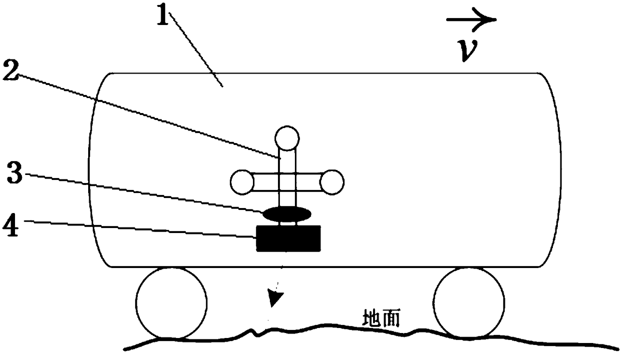
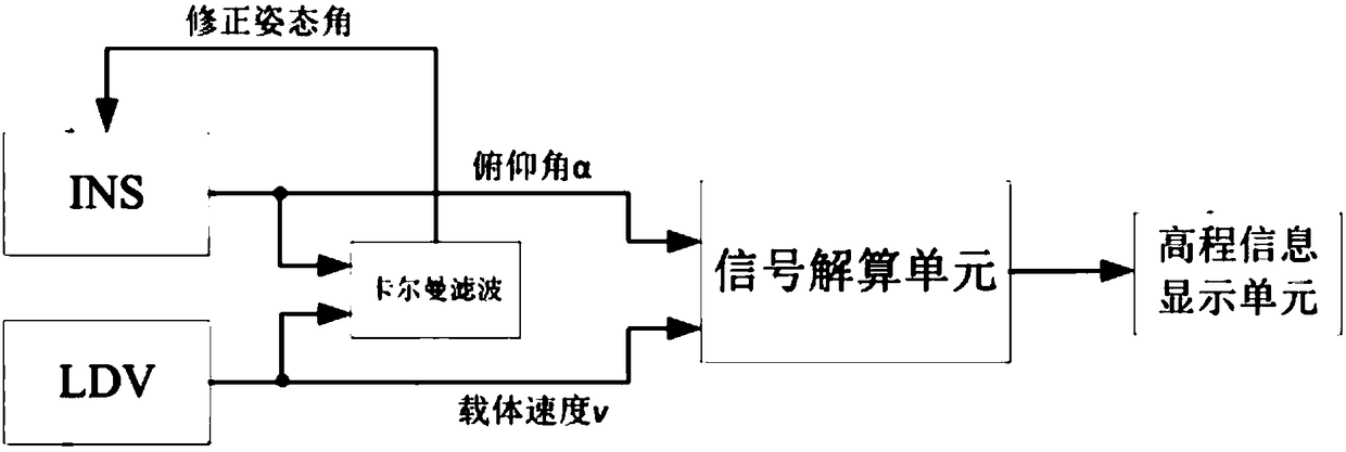
[0052] refer to figure 1 and figure 2 , a vehicle-mounted altimeter based on LDV / INS combination, the vehicle-mounted altimeter includes an inertial navigation system 3, a laser Doppler velocimeter 4, a signal calculation unit and an elevation information display unit. The vehicle-mounted altimeter can be installed on the vehicle 1 as a whole, that is, the inertial navigation system 3 , the laser Doppler velocimeter 4 , the Kalman filter, the signal calculation unit and the elevation information display unit are all installed on the vehicle 1 . Both the inertial navigation system 3 and the laser Dopple...


PUM


Abstract

The invention discloses a LDV/INS (Laser Doppler Velocimeter/Inertial Navigation System) combination-based vehicle-mounted height measurer and a method thereof. The vehicle-mounted height measurer comprises an inertial navigation system, a laser Doppler velocimeter, a signal solving unit and a height information display unit, wherein the inertial navigation system and the laser Doppler velocimeterare arranged on a vehicle; the inertial navigation system is used for measuring a real-time pitch angle of the vehicle in the driving process and transmitting the measured real-time pitch angle information to the signal solving unit; the laser Doppler velocimeter is used for measuring a real-time speed in the vehicle driving process and transmitting the measured real-time speed information to thesignal solving unit; the signal solving unit is used for solving to obtain an elevation height increment of the vehicle in a set unit time interval according to the speed information and the pitch angle information, accumulating all height increments from an initial point to a to-be-measured point, and finally solving the elevation of the to-be-measured point. The vehicle-mounted height measurerdisclosed by the invention has the characteristics of being capable of avoiding influence of meteorological changes, small in influence of atmospheric refraction, high in working efficiency, high in measurement accuracy and the like.

Description

technical field [0001] The invention relates to the technical field of laser and precision measurement, in particular to a method for realizing a novel vehicle-mounted altimeter based on an inertial navigation system (INS) and a laser Doppler velocimeter (LDV), which is mainly used for measuring land terrain height. Background technique [0002] At present, there are many methods for measuring the elevation of ground points, such as: leveling, GPS elevation measurement, triangulation elevation measurement and barometric elevation measurement. [0003] Leveling uses a horizontal line of sight, with the help of a ruler erected on the ground point, to measure the height difference between two points on the ground, and calculate the height of the point to be measured according to the height of the initial point. Leveling has the highest accuracy and is mainly used to establish a national or regional elevation control network. The basic principle of GPS height measurement is to ...

Claims


Application Information

Patent Timeline
Patent Type & Authority Applications(China)
IPC IPC(8): G01C5/00
CPCG01C5/00
Inventor 陈鹏
Owner BEIJING HANGTIANGUANGXIN TECH CO LTD
Why Eureka
Try Eureka