A real-time digital surface model generation method

A digital surface model and horizontal plane technology, applied in the fields of computer vision and map surveying, can solve the problems of difficult updating, heavy workload, and low precision, and achieve the goal of avoiding redundant texture storage, reducing memory consumption, and small time complexity Effect

Active Publication Date: 2019-01-18
NORTHWESTERN POLYTECHNICAL UNIV
View PDF7 Cites 14 Cited by
  • Summary
  • Abstract
  • Description
  • Claims
  • Application Information

AI Technical Summary

Problems solved by technology

[0004] Although the elevation points or contour lines can be collected through the above-mentioned methods of obtaining original data, and then further interpolated to obtain DSM, the disadvantages are also obvious: (1) The method of obtaining data based on ground measurement requires manual work throughout the process, and The workload is huge, the cycle is long, the update is very difficult, and the cost is high. Generally, it is not suitable for large-scale data collection. In addition, the accuracy of the topographic map determines the credibility of the topographic map for the actual terrain expression. The smaller the scale of the topographic map, the higher the accuracy of the topographic map. The greater the degree of comprehensiveness, the more generalized and approximate the terrain represented, and vice versa; (2) The method of using altimetry to obtain the original data has low accuracy, high cost, and difficult implementation
(3) Among the methods of obtaining data by photogrammetry, the accuracy of elevation data obtained by the method of aerospace imagery is low, and only large-scale and small-scale data can be obtained, which has certain limitations
Although this method can generate DSM and achieve good results, most of the existing DSM generation algorithms are offline because the traditional SFM often focuses on processing a large number of disordered images rather than real-time positioning and mapping. Online and real-time speed, and the existing offline algorithm takes a long time

Method used


Image

  • A real-time digital surface model generation method
  • A real-time digital surface model generation method
  • A real-time digital surface model generation method

Examples


Embodiment Construction

[0051] Embodiments of the present invention are described in detail below, and the embodiments are exemplary and intended to explain the present invention, but should not be construed as limiting the present invention.

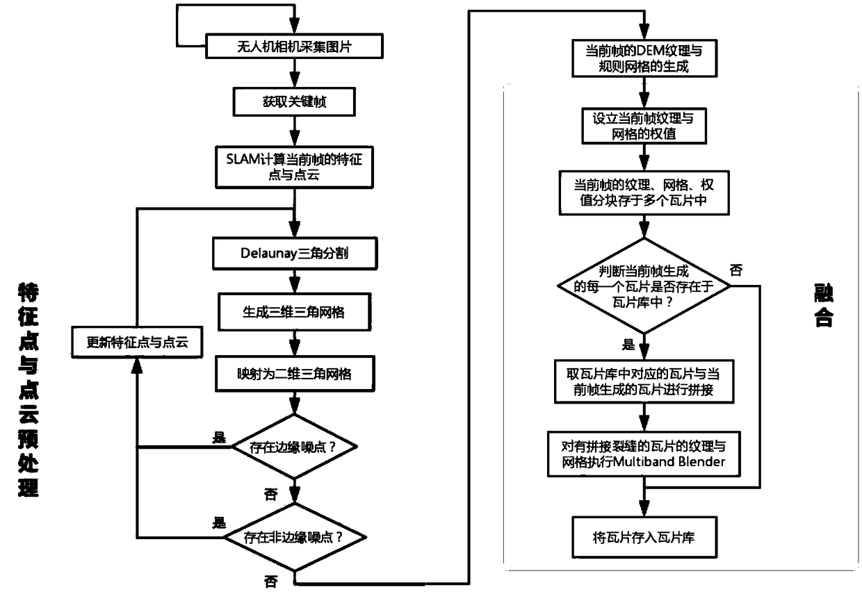
[0052] attached figure 1 It shows the overall flow of the present invention to realize real-time digital surface model generation. The purpose of the present invention is to use the pictures taken by the camera carried by the drone and the feature points and point clouds of the current frame obtained through SLAM as input data, and the feature points and point clouds are preprocessed to remove noise, and then generate DSM textures and rules grid, and store the texture and regular grid in tiles, and then merge with the tiles in the tile library to generate a digital surface model in real time.

[0053] The following are the specific implementation steps.

[0054] Step 1: The airborne camera captures the surface image in real time, and performs real-time SLAM ...


PUM


Abstract

The invention provides a real-time digital surface model generation method, which takes the current frame image taken by a camera carried by an unmanned aerial vehicle and the current frame feature points and point clouds outputted by the SLAM as input data, and generates a DSM in real-time. Firstly, the airborne camera captures the real-time surface image and processes it with real-time SLAM to obtain the feature points of the current frame and the constructed map point cloud; and the feature points of the current frame and the map point cloud are pretreated in advance; Secondly, the DSM texture and regular mesh of the current frame are generated. Finally, DSM texture and regular mesh fusion are carried out respectively. The invention can meet the real-time requirement, has the advantages of fast generation speed, small time complexity, low memory consumption, high robustness and precision, and good splicing effect.

Description

technical field [0001] The invention relates to the fields of computer vision and map surveying, in particular, a real-time digital surface model (DSM, Digital Surface Model) generation method. Background technique [0002] DSM (Digital Surface Model) refers to the ground elevation model that includes the height of surface buildings, bridges and trees. DSM can truly express the ground ups and downs. It has a wide range of applications in surveying and mapping, hydrology, meteorology, geomorphology, geology, soil, engineering construction, communications, military and other national economic and national defense construction, as well as humanities and natural sciences. For example, in forest areas, it can be used to detect the growth of forests; in urban areas, DSM can be used to check the development of cities; especially the well-known cruise missiles, which not only require digital ground models (DSM), but also digital Surface model, so that it is possible to make the cru...

Claims


Application Information

Patent Timeline
Patent Type & Authority Applications(China)
IPC IPC(8): G06T7/11G06T7/13G06T3/40G06F16/29
CPCG06T3/4038G06T7/11G06T7/13
Inventor 布树辉王伟赵勇
Owner NORTHWESTERN POLYTECHNICAL UNIV
Why Eureka
Try Eureka