Intelligent method of path optimal selection for parallel processing of remote sensing images based on data segmentation

A remote sensing image, parallel processing technology, applied in the field of remote sensing and geographic information systems, can solve problems such as increasing the amount of information, and achieve the effect of satisfying time-consuming, simple and practical principles

Active Publication Date: 2019-02-22
FUDAN UNIV
View PDF5 Cites 0 Cited by
  • Summary
  • Abstract
  • Description
  • Claims
  • Application Information

AI Technical Summary

Problems solved by technology

The ellipse in the figure is the detected target, and it will automatically generate vector polygons and vector points, resulting in an increase in the amount of information

Method used


Image

  • Intelligent method of path optimal selection for parallel processing of remote sensing images based on data segmentation
  • Intelligent method of path optimal selection for parallel processing of remote sensing images based on data segmentation
  • Intelligent method of path optimal selection for parallel processing of remote sensing images based on data segmentation

Examples


Embodiment

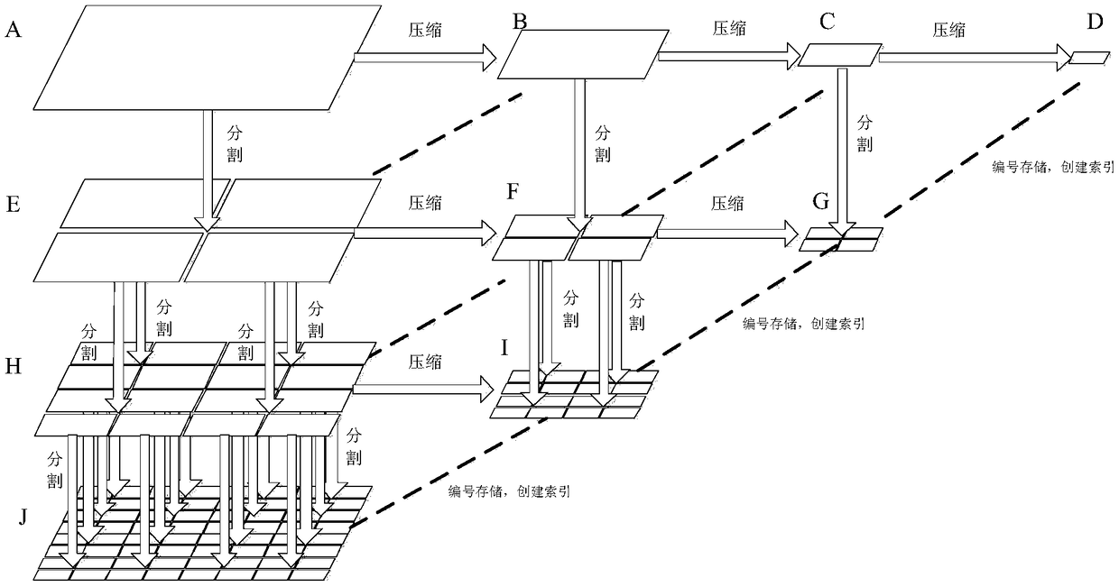
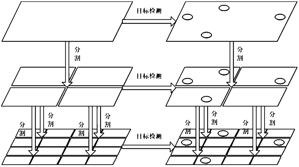
[0072] Using C# language programming to realize the path optimal selection intelligent method of remote sensing image parallel processing based on data segmentation, using 10 computing nodes, for a coastal image data (format: TIF; data volume 197.8M; size 7129×7151; pixel depth 8bit) for processing, construct 8, 10, 12-layer quadtree pyramids, and record the total time. After processing, read the MFlag value and find that the MFlag value is false, that is to say, the computer automatically adopts the parallel strategy of compressing first and then splitting, and then forcefully sets the MFlag value to true, forcing the computer to adopt the parallel strategy of splitting first and then compressing, and build 8, 10, 12 layers of quadtree pyramid, record the total time. Then request compression and segmentation operations respectively, and the computing nodes in the cloud use the ENVI / IDL algorithm to perform compression (compress a piece of image data according to the compressi...


PUM


Abstract

The invention belongs to the technical field of remote sensing and geographic information system, and relates to an intelligent method for path optimal selection of parallel processing of remote sensing images based on data segmentation. The invention firstly obtains an input remote sensing image, Then, the information cost o of the parallel processing program , the relative information amount r and the number of elements n of the remote sensing image in each step is calculated automatically according to the training samples;. Then the cost ratio Phi p / Phi 'p and the ratio (rj x ni) / (rj + 1 xni + 1) of relative information and element number of each processing step are calculated. Finally, according to this ratio, the optimal path of parallel processing of remote sensing image is determined and obtained. The invention solves the path dynamic and optimal selection problems caused by the multi-path reachability of the processing model when the parallel technology is applied to the field of distributed storage and processing of remote sensing images, and the principle is simple and practical, and meets the requirements of the shortest time consuming and the highest efficiency of theparallel processing.

Description

technical field [0001] The invention belongs to the technical field of remote sensing and geographic information systems, and in particular relates to an intelligent method for path optimal selection based on parallel processing of remote sensing images based on data segmentation. Background technique [0002] In raster data structures, space is regularly divided into grids (usually squares). The location and status of geographic entities are defined by the grid row and column numbers they occupy. The size of each grid represents the defined spatial resolution. The smaller the grid unit, the higher the resolution of the data, but relatively speaking, the larger the data volume of the data file. [0003] Raster data can be regarded as a 2-dimensional matrix. The quadtree pyramid organization method or wavelet pyramid organization method of raster data actually forms a parallel / distributed storage structure. That is, the data is distributed in a three-dimensional space. Th...

Claims


Application Information

Patent Timeline
Patent Type & Authority Applications(China)
IPC IPC(8): G06F16/29G06F9/38G06T1/20
CPCG06F9/3885G06T1/20G06T2207/10032G06T2207/20081
Inventor 方雷王祥荣谢玉静樊正球姚申君刘涛王雨
Owner FUDAN UNIV
Why Eureka
Try Eureka