
LS-SVM-based self-adaptive fault-tolerant GPS/INS integrated navigation method

A technology of integrated navigation and navigation method, which is applied in directions such as navigation through speed/acceleration measurement, satellite radio beacon positioning system, measurement device, etc., which can solve the adverse effects of GPS/INS integrated navigation system stability and affect the real-time performance of fault-tolerant processing. , locating application threats, etc., to achieve reliable and accurate fault diagnosis results, reduce computational complexity, and improve sensitivity.

Active Publication Date: 2019-03-15
北京青云智创科技有限公司
View PDF5 Cites 13 Cited by
  • Summary
  • Abstract
  • Description
  • Claims
  • Application Information

AI Technical Summary

Problems solved by technology

The existing satellite navigation system cannot completely avoid the adverse effects of failures and disturbances
Especially in the navigation system where INS and GPS are mutually assisted, GPS errors and INS errors are highly coupled to each other. If fault tolerance is not handled in time under fault conditions, the overall stability of the GPS / INS integrated navigation system will decrease or even fail to work properly.
In addition, as the original satellite observation information used in the combined observations of the GPS / INS integrated navigation system, the pseudorange and pseudorange rate are extremely vulnerable to clock drift, orbital parameter modeling errors, signal distortion, and ionization interference during the generation, transmission, and reception processes. Slowly changing slope errors due to the influence of factors such as
For example, in January 2004, GPS's PRN23 clock drifted, which eventually caused the positioning error to increase to several kilometers
The delay in fault detection will further affect the real-time performance of fault-tolerant processing, and the continuous accumulation of faults will have a serious adverse effect on the stability of the GPS / INS integrated navigation system.

Method used


Image

  • LS-SVM-based self-adaptive fault-tolerant GPS/INS integrated navigation method
  • LS-SVM-based self-adaptive fault-tolerant GPS/INS integrated navigation method
  • LS-SVM-based self-adaptive fault-tolerant GPS/INS integrated navigation method

Examples


Embodiment Construction

[0025] The present invention will be described in detail below with reference to the accompanying drawings and examples.

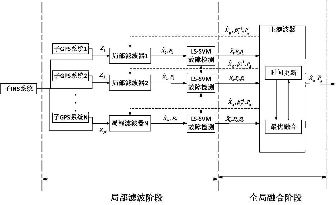
[0026] This embodiment provides an adaptive fault-tolerant GPS / INS integrated navigation method based on LS-SVM. The overall flow chart is as follows figure 1 shown.

[0027] The specific process includes the following steps:

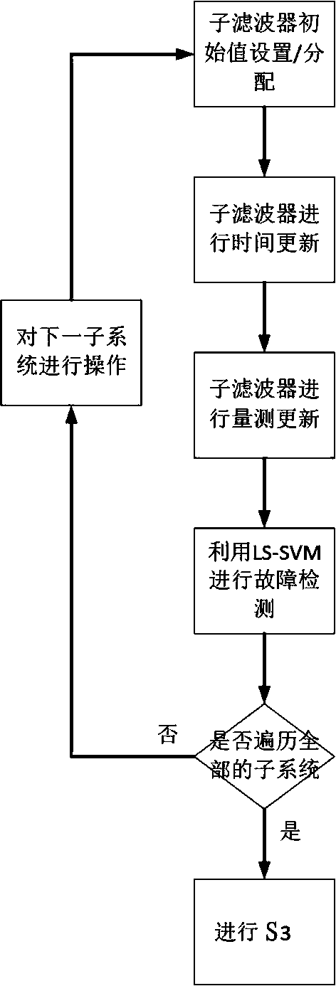
[0028] S1: Construct / update the GPS / INS integrated navigation system model and model parameters according to the current navigation results (including information such as attitude, speed, and position), and the GPS / INS integrated navigation system model includes multiple sub-GPS / INS navigation systems; The GPS / INS integrated navigation system is composed of an INS system and n GPS systems, and the n GPS systems include GPS-1 system, GPS-2 system...GPS-n system, then the sub-GPS / INS navigation system Including sub-GPS / INS navigation system-1, GPS / INS navigation system-2...GPS / INS navigation system-n, the sub-GPS / INS navigation syst...


PUM


Abstract

The invention provides an LS-SVM-based self-adaptive fault-tolerant GPS / INS integrated navigation method. The method is briefly characterized in that if an LS / SVM considers that a certain current sub-navigation system breaks down, the weight of the sub-navigation system in information fusion is lowered, the weight for other sub-navigation systems is increased, and therefore fault isolation is achieved. When the LS-SVM detects that fault information is repaired, the weight of the corresponding navigation sub-system is recovered to be normal, and therefore it is ensured that all normally-workingsub-navigation systems take part in information fusion, and the purpose of improving the precision of the integrated navigation system is achieved. Compared with the prior art, the navigation methodhas the advantages that when a fault exists, fault detection and isolation can be effectively achieved, and it is ensured that the navigation precision is not affected by fault information; when not fault exists, optimal information fusion of all the normally-working sub-navigation systems can be effectively achieved, and the navigation precision of the integrated navigation system is improved tothe maximum extent.

Description

technical field [0001] The invention belongs to the technical field of integrated navigation, in particular to an adaptive fault-tolerant GPS (Global Positioning System, Global Positioning System) / INS (Inertial Navigation System, Inertial navigation system) integrated navigation method. Background technique [0002] The GPS / INS integrated navigation system based on the complementary characteristics of inertial and satellite navigation systems can realize all-day and all-weather continuous navigation around the world. It is one of the main directions of navigation technology development in recent years and for a long period of time in the future. Among them, INS, as the main navigation system, has good autonomy and concealment, and can provide complete navigation information of the carrier, including position, speed and attitude angle; the data update rate is high, the short-term accuracy is high, the stability is good, and it is not easily affected by external signals. Inte...

Claims


Application Information

Patent Timeline
IPC IPC(8): G01S19/49G01C21/16
CPCG01C21/16G01S19/49
Inventor 梁源徐兵
Owner 北京青云智创科技有限公司
Learn More