Amphibious unmanned surveying and mapping boat and surveying and mapping method thereof

An amphibious and hull technology, applied to unmanned surface ships, amphibious vehicles, surveying, mapping and navigation, etc., can solve the problems of manpower and material resources, low efficiency, etc., to solve low efficiency, improve efficiency, and avoid excessive hull quality big effect

Inactive Publication Date: 2019-04-12
SHANGHAI UNIV
View PDF11 Cites 6 Cited by
  • Summary
  • Abstract
  • Description
  • Claims
  • Application Information

AI Technical Summary

Problems solved by technology

However, the deployment and recovery of the unmanned boat requires the cooperation of the mother ship and the crane during the transportation process, which consumes a lot of manpower and material resources, resulting in low efficiency.

Method used


Image

  • Amphibious unmanned surveying and mapping boat and surveying and mapping method thereof
  • Amphibious unmanned surveying and mapping boat and surveying and mapping method thereof
  • Amphibious unmanned surveying and mapping boat and surveying and mapping method thereof

Examples


Embodiment 1

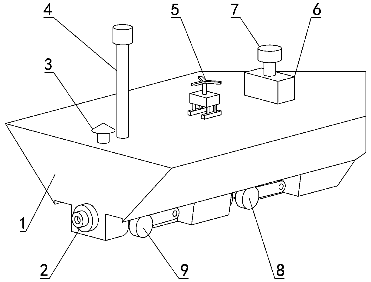
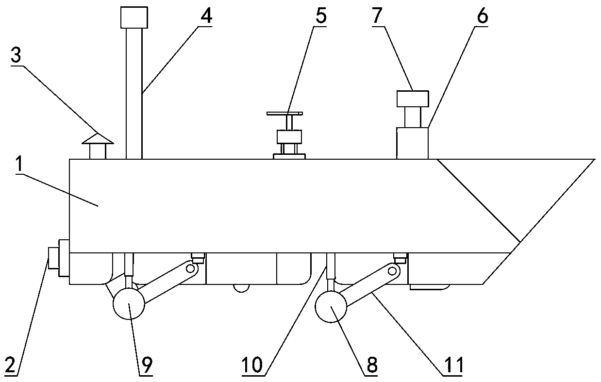
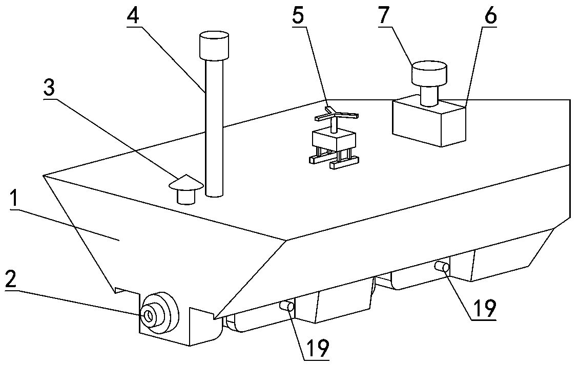
[0029] see Figure 1-Figure 6 , an amphibious unmanned surveying and mapping boat, including a hull 1, a GPS device 3, a communication antenna 4, a control box 6, an unmanned aerial vehicle 5 and a radar 7 are arranged on the deck of the hull; wherein, the GPS device 3 is used for the entire land and water The determination of the position and pose information of the amphibious unmanned mapping boat; the communication antenna 4 is used for the communication between the amphibious unmanned mapping boat and the shore-based workstation and the UAV 5, so that the shore-based staff can fully grasp the location and orientation of the amphibious unmanned mapping boat. Dynamic information and issuing orders; the control box 6 is used to send control commands to all equipment on the amphibious unmanned mapping boat; the unmanned aerial vehicle 5 is used to cooperate with the unmanned mapping boat to realize the integration of sea and air surveying and mapping; the radar 7 is located in ...

Embodiment 2

[0033] A method of using the amphibious unmanned surveying and mapping boat described in embodiment 1 to carry out marine surveying and mapping, comprising the following steps:

[0034] (1) When receiving the surveying and mapping task, the amphibious unmanned surveying and mapping boat travels from the land to the water area according to the positioning information of the GPS device 3, and then the engine 18 continues to drive the rear wheel system to drive toward the water. When the camera 13 monitors the bottom of the hull 1 When both are submerged in water, turn off the engine 18, and at the same time shrink the hydraulic telescopic cylinder 10, and recover the front wheel system and the rear wheel system into the front wheel system recovery cavity 14 and the rear wheel system recovery cavity 15 respectively;

[0035] (2) The control box 6 controls the engine 18 to provide power to the water jet propeller 2, starts the engine 18, and the engine 18 drives the water jet prope...


PUM


Abstract

The invention belongs to the technical field of unmanned boats and particularly discloses an amphibious unmanned surveying and mapping boat. The amphibious unmanned surveying and mapping boat comprises a boat body, wherein the boat body is provided with a control cabinet; a water-jet propeller is arranged at the tail of the boat body; a front wheel system and a rear wheel system are arranged at the bottom of the boat body; a sonar is arranged at the front end of the bottom surface of the boat body; the front wheel system comprises a front wheel support; one end of the front wheel support is rotationally connected with the bottom of the boat body; front rollers are rotationally connected to two sides of the other end of the front wheel support; the rear wheel system comprises a rear wheel support; one end of the rear wheel support is rotationally connected with the bottom of the boat body; rear rollers are rotationally connected to two sides of the other end of the rear wheel support; hydraulic telescopic cylinders are hinged to the front wheel support and the rear wheel support; the bottoms of the hydraulic telescopic oil cylinders are rotationally connected with the bottom surfaceof the boat body; a front wheel system recovering cavity matched with the front wheel system is formed in the front end of the bottom surface of the boat body; a rear wheel system recovering cavity matched with the rear wheel system is formed in the rear end of the bottom surface of the boat body. The amphibious unmanned surveying and mapping boat is simple in structure and reasonable in design,and can finish the marine surveying and mapping task under the condition of no manual intervention.

Description

technical field [0001] The invention belongs to the technical field of unmanned boats, in particular to an amphibious unmanned surveying and mapping boat. Background technique [0002] In recent years, with the gradual expansion of the maritime strategy, the protection of national territorial integrity and the protection of national maritime rights and interests cannot be separated from the guarantee of marine surveying and mapping, especially in modern high-tech warfare, which requires modern marine surveying and mapping support. Therefore, marine surveying and mapping is already a basic construction work, which has been valued and developed by countries all over the world. When the current surveying and mapping boats perform tasks, they are usually manned, and there is a risk of casualties when performing tasks in unsafe waters. With its advantages of small size, shallow draft, and unmanned driving, unmanned boats have broad application prospects in chart surveying and ma...

Claims


Application Information

Patent Timeline
Patent Type & Authority Applications(China)
IPC IPC(8): B60F3/00B63B35/00G01C11/00G01C13/00B63H11/02
CPCB60F3/0007B63B35/00B63B2035/006B63H11/02G01C11/00G01C13/00
Inventor 谢少荣王纯新陈汇资张丹彭艳柯俊罗均蒲华燕
Owner SHANGHAI UNIV
Why Eureka
Try Eureka