Inertial navigation high-precision positioning method based on binocular, acceleration and gyroscope

A technology of inertial navigation and positioning method, which is applied to navigation, surveying and mapping, navigation, navigation and other directions through speed/acceleration measurement, which can solve the problems of not being able to eliminate the cumulative error of inertial navigation and the complexity of related algorithms, and achieve good real-time performance , simple tools and processes, improved stability and robustness

Active Publication Date: 2019-04-16
CHONGQING UNIV OF POSTS & TELECOMM
View PDF14 Cites 22 Cited by
  • Summary
  • Abstract
  • Description
  • Claims
  • Application Information

AI Technical Summary

Problems solved by technology

[0005] Nowadays, there are many data fusion algorithms for visual navigation and inertial navigation, but these fusion algor...

Method used


Image

  • Inertial navigation high-precision positioning method based on binocular, acceleration and gyroscope
  • Inertial navigation high-precision positioning method based on binocular, acceleration and gyroscope
  • Inertial navigation high-precision positioning method based on binocular, acceleration and gyroscope

Examples


Embodiment approach

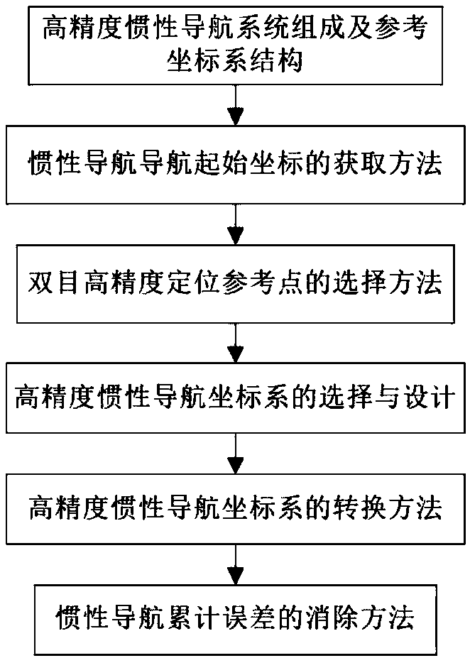
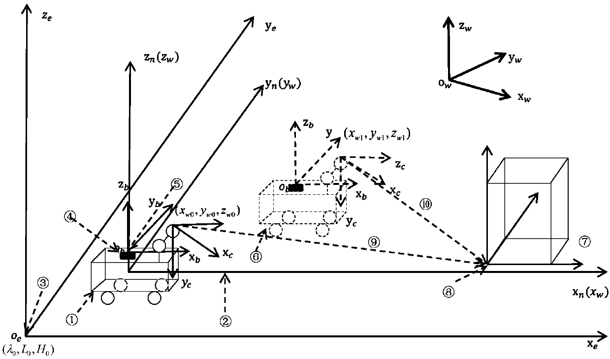
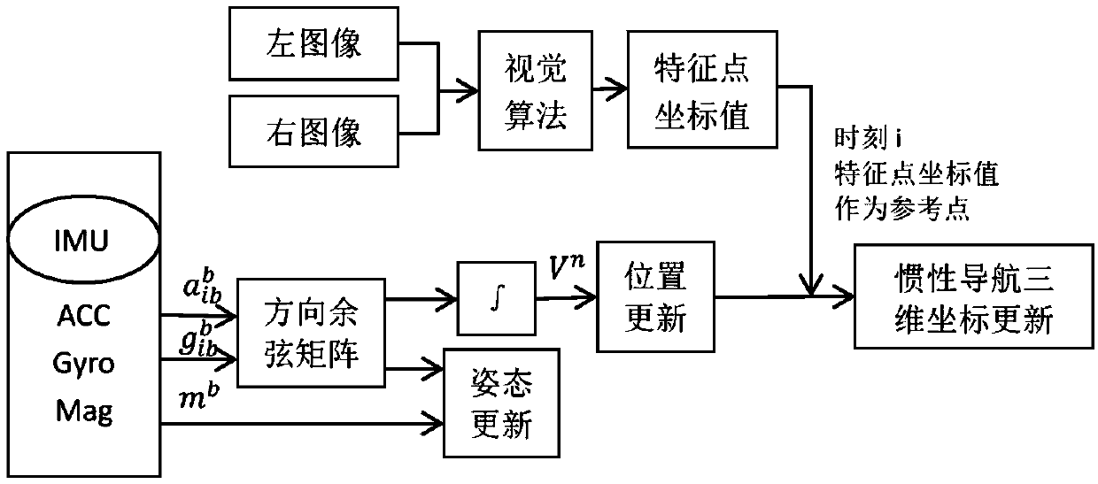
[0077] The purpose of the present invention is to determine the three-dimensional coordinates of the feature points of the inertial navigation reference position based on binocular positioning + high-precision GPS information, and use the coordinate values ​​of the feature points as reference points to update the three-dimensional coordinates of the inertial navigation in real time to eliminate the cumulative error caused by the integration of the inertial navigation , to achieve precise positioning based on inertial navigation and binocular positioning combined with auxiliary indoor parking lot vehicles. To achieve this purpose, the specific implementation methods are as follows:

[0078] According to the actual situation, when the vehicle enters the parking lot and completes the whole process of parking, the present invention firstly provides a method for acquiring the initial coordinates of the inertial navigation. In the present invention, the important condition that the ...


PUM


Abstract

The invention requests the protection of an inertial navigation high-precision positioning method based on binocular, acceleration and gyroscope. The three-dimensional coordinates of the characteristic points of an inertial navigation reference position are determined based on binocular positioning and high-precision GPS information, and the three-dimensional coordinates of inertial navigation areupdated in real time by using the coordinate values of the characteristic points as reference points to eliminate the cumulative error caused by the integration of inertial navigation, and assist inhigh precision positioning of vehicles in an indoor parking lot based on inertial navigation and binocular positioning. A structure block diagram of the invention includes the following parts: I, thecomposition of a high precision inertial navigation system and the structure of a reference coordinate system; II, an acquisition method of the initial coordinates of inertial navigation; III, a selection method of binocular high precision positioning reference points; IV, the selection and design of a high precision inertial navigation coordinate system; V, a conversion method of a high precisioninertial navigation coordinate system; and VI, an elimination method of the cumulative error of inertial navigation.

Description

technical field [0001] The invention belongs to the field of high-precision positioning of integrated navigation, and in particular relates to a high-precision positioning method based on indoor parking visual navigation assisted inertial navigation. Background technique [0002] As a popular positioning method, GPS has been widely used in land vehicle positioning, but the signal of GPS for indoor parking is often blocked. Indoor high-precision positioning is helpful for vehicles to quickly find a suitable parking space through the navigation route. In the current situation where there are many indoor parking lots, this technology is very necessary. [0003] The inertial navigation system (Inertial Navigation System, INS) uses Newton's law of mechanics as the working principle, uses the inertial measurement unit (Inertial Mcasurement Unit, IMU) installed on the carrier to measure the angular velocity and acceleration information of the carrier, and obtains the position of th...

Claims


Application Information

Patent Timeline
IPC IPC(8): G01C21/16G01S19/48G01S19/49
CPCG01C21/165G01S19/48G01S19/49
Inventor 蒋建春杨谊曾素华欧小龙赵龙明王蓉任凡
Owner CHONGQING UNIV OF POSTS & TELECOMM
Why Eureka
Try Eureka