Supercharge Your Innovation With Domain-Expert AI Agents!

Big data-based survey data processing method

A big data and data technology, applied in the direction of electrical digital data processing, special data processing applications, database management systems, etc., can solve the problems that restrict the wide application of geological mapping, to make up for the lack of geological information, improve quality, and improve accuracy sexual effect

Inactive Publication Date: 2019-04-19
国勘数字地球(北京)科技有限公司
View PDF4 Cites 2 Cited by
  • Summary
  • Abstract
  • Description
  • Claims
  • Application Information

AI Technical Summary

Problems solved by technology

This working method makes the role of multi-source and heterogeneous exploration data very limited, which restricts its wide application in geological mapping.

Method used


Image

  • Big data-based survey data processing method
  • Big data-based survey data processing method
  • Big data-based survey data processing method

Examples


Embodiment Construction

[0032] The following will clearly and completely describe the technical solutions in the embodiments of the present invention with reference to the accompanying drawings in the embodiments of the present invention. Obviously, the described embodiments are some of the embodiments of the present invention, but not all of them. Based on the embodiments of the present invention, all other embodiments obtained by persons of ordinary skill in the art without making creative efforts belong to the protection scope of the present invention.

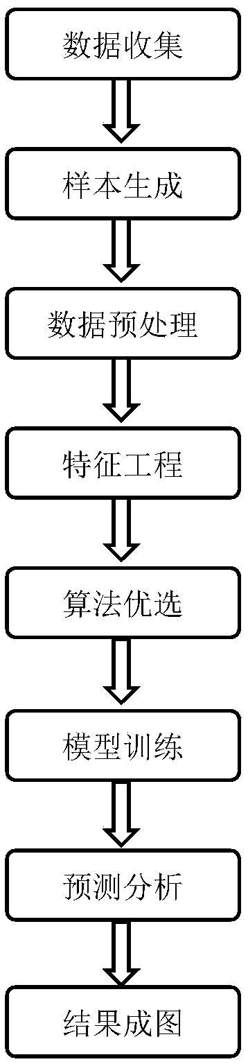
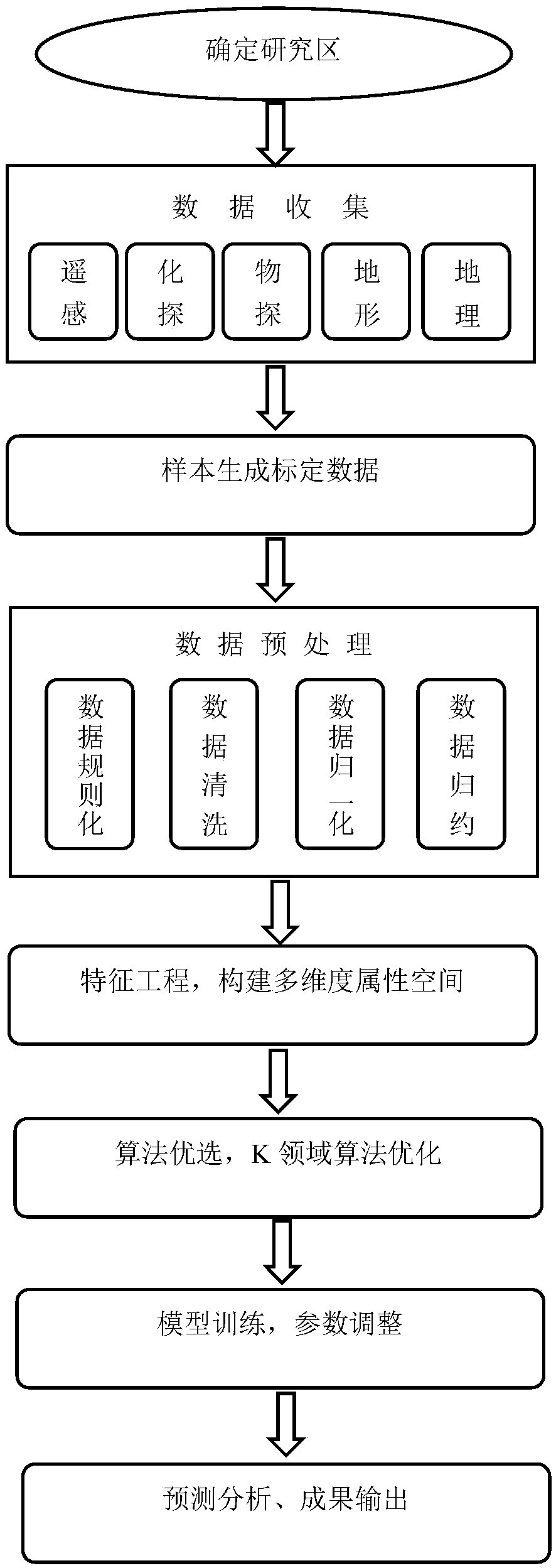
[0033] Such as figure 2 Shown is the method flow chart of the embodiment of the present invention, and concrete process is as follows:

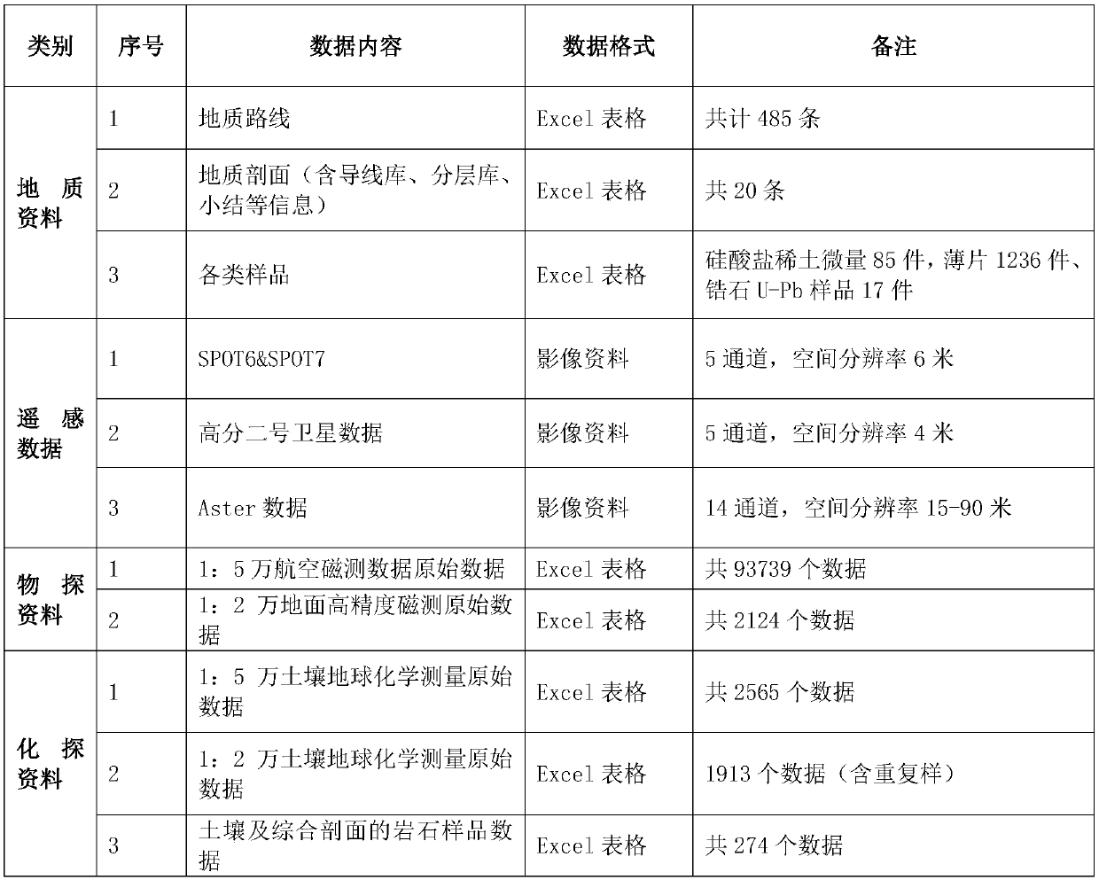
[0034] Step S10: Acquire existing multi-source heterogeneous exploration data of various scales in a certain research area in Heilongjiang, such as: airborne magnetic data, gravity data and other geophysical data, SPOT series, Aster, Gaofen-2 and other remote sensing data Image data, soil geochemical element me...


PUM


Abstract

The invention relates to a big data-based survey data processing method. The method comprises the following steps of obtaining multi-source heterogeneous survey data under various existing scales in aresearch area; According to a specific task of the geological mapping of the research area and an existing geological understanding result, determining a mark type of the task, and selecting a representative sample with mark information to form a mark space; Carrying out data preprocessing on the collected multi-source heterogeneous exploration data; Feature engineering: constructing a feature space; For a specific geological mapping task in the research area, testing a big data analysis algorithm, and carrying out algorithm optimization and algorithm optimization; Carrying out data-based model construction and parameter debugging by utilizing an optimized algorithm; Performing prediction analysis; And outputting the initial geological mapping. According to the method, various multi-source heterogeneous exploration data can be fully and effectively utilized, the arrangement of profiles, routes and observation points in the geological mapping is optimized, and finally the quality of geological mapping results is improved.

Description

technical field [0001] The invention relates to the field of data analysis of survey data, in particular to a method for processing survey data based on big data. Background technique [0002] Since the 1990s, Western developed countries such as Canada, Australia, and the United States have comprehensively applied geophysical prospecting (geophysical prospecting), geochemical prospecting (geochemical prospecting), and remote sensing to geological mapping work, especially when covering area, as the main way to improve the level of geological research. [0003] The coverage area of ​​my country accounts for more than 1 / 3 of the country's land area, and a considerable part of it is a shallow coverage area with a cover layer thickness of no more than 100m (the thickness of the Quaternary cover layer is less than 100m, and the cover layer area accounts for 50% of the map area. or more than 50% of the region). In the geological mapping of shallow coverage areas, conventional mapp...

Claims


Application Information

Patent Timeline
IPC IPC(8): G06F16/21G06F16/23G06F16/215G06F16/25
Inventor 周艳伟
Owner 国勘数字地球(北京)科技有限公司
Features
  • R&D
  • Intellectual Property
  • Life Sciences
  • Materials
  • Tech Scout
  • Unparalleled Data Quality
  • Higher Quality Content
  • 60% Fewer Hallucinations
Learn More