A high-space remote sensing estimation method for soil organic carbon density in a desertification region

A high-density, organic carbon technology, applied in special data processing applications, instruments, electrical and digital data processing, etc., can solve the problems of large spatial scale, climatic conditions, insufficient estimation accuracy, and inability to adapt, to improve application capabilities Effect

Active Publication Date: 2019-06-25
RES INST OF FOREST RESOURCE INFORMATION TECHN CHINESE ACADEMY OF FORESTRY
View PDF2 Cites 11 Cited by
  • Summary
  • Abstract
  • Description
  • Claims
  • Application Information

AI Technical Summary

Problems solved by technology

[0006] The technical problem to be solved by the present invention is to provide a method suitable for high spatial remote sensing estimation of soil organic carbon density in semi-arid desertification areas, aiming to take advantage of the high spatial resolution of GF-1 WFV data and the high time resolution of MODIS data By optimizing the relevant carbon cycle model parameters, the remote sensing estimation of soil organic carbon density in desertified areas with high temporal and spatial resolution can be realized; in traditional estimation methods, the spatial scale is large, and it is difficult to accurately reflect the spatial distribution characteristics of soil organic carbon density. Model parameters are often replaced by empirical constants, which cannot adapt to the characteristics of vegetation growth and climatic conditions in the study area, and the estimation accuracy is insufficient

Method used


Image

  • A high-space remote sensing estimation method for soil organic carbon density in a desertification region
  • A high-space remote sensing estimation method for soil organic carbon density in a desertification region
  • A high-space remote sensing estimation method for soil organic carbon density in a desertification region

Examples


Embodiment Construction

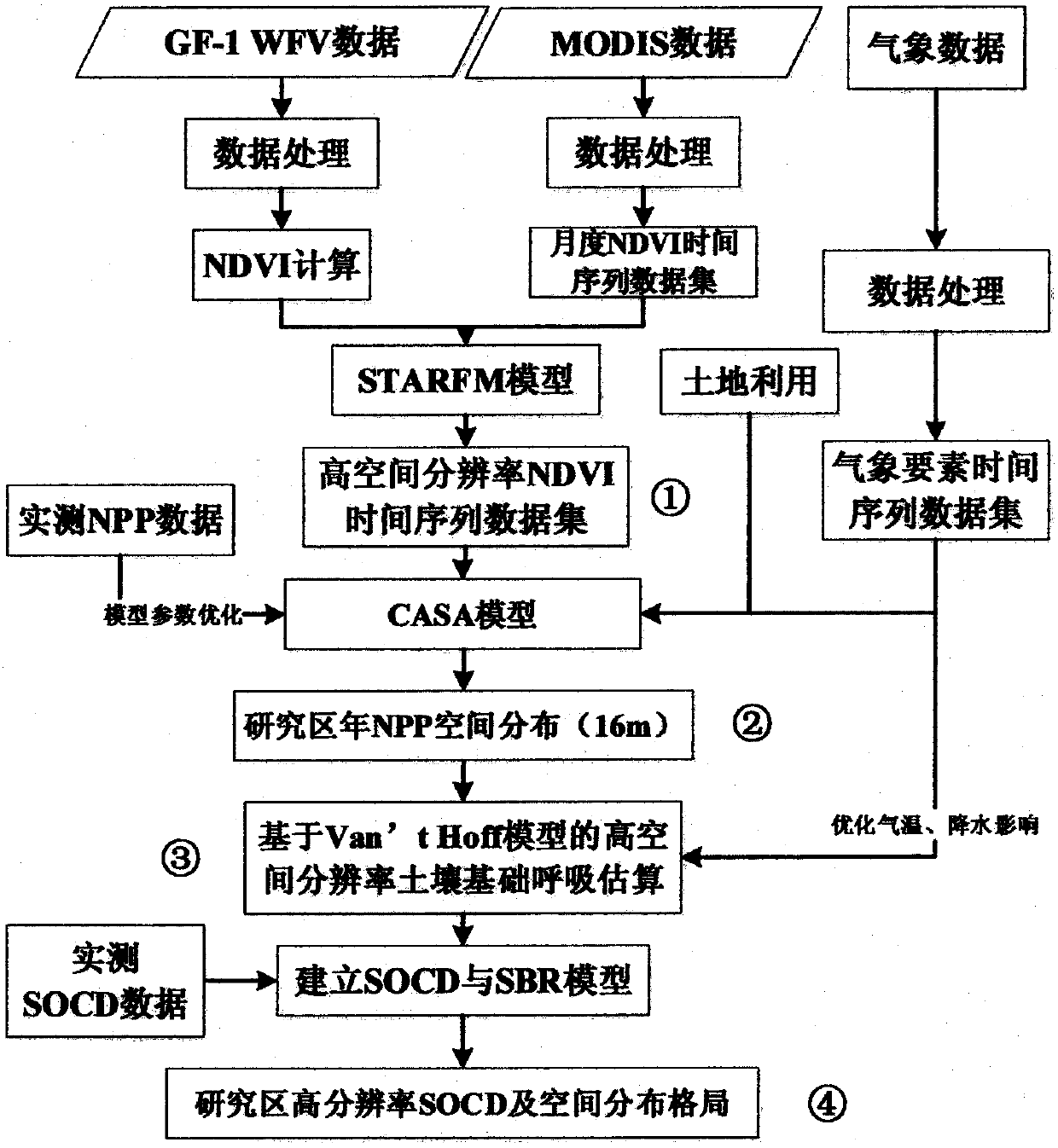
[0021] The following will clearly and completely describe the technical solutions in the embodiments of the present invention with reference to the accompanying drawings in the embodiments of the present invention. Obviously, the described embodiments are only some, not all, embodiments of the present invention. Based on the embodiments of the present invention, all other embodiments obtained by persons of ordinary skill in the art without making creative efforts belong to the protection scope of the present invention.

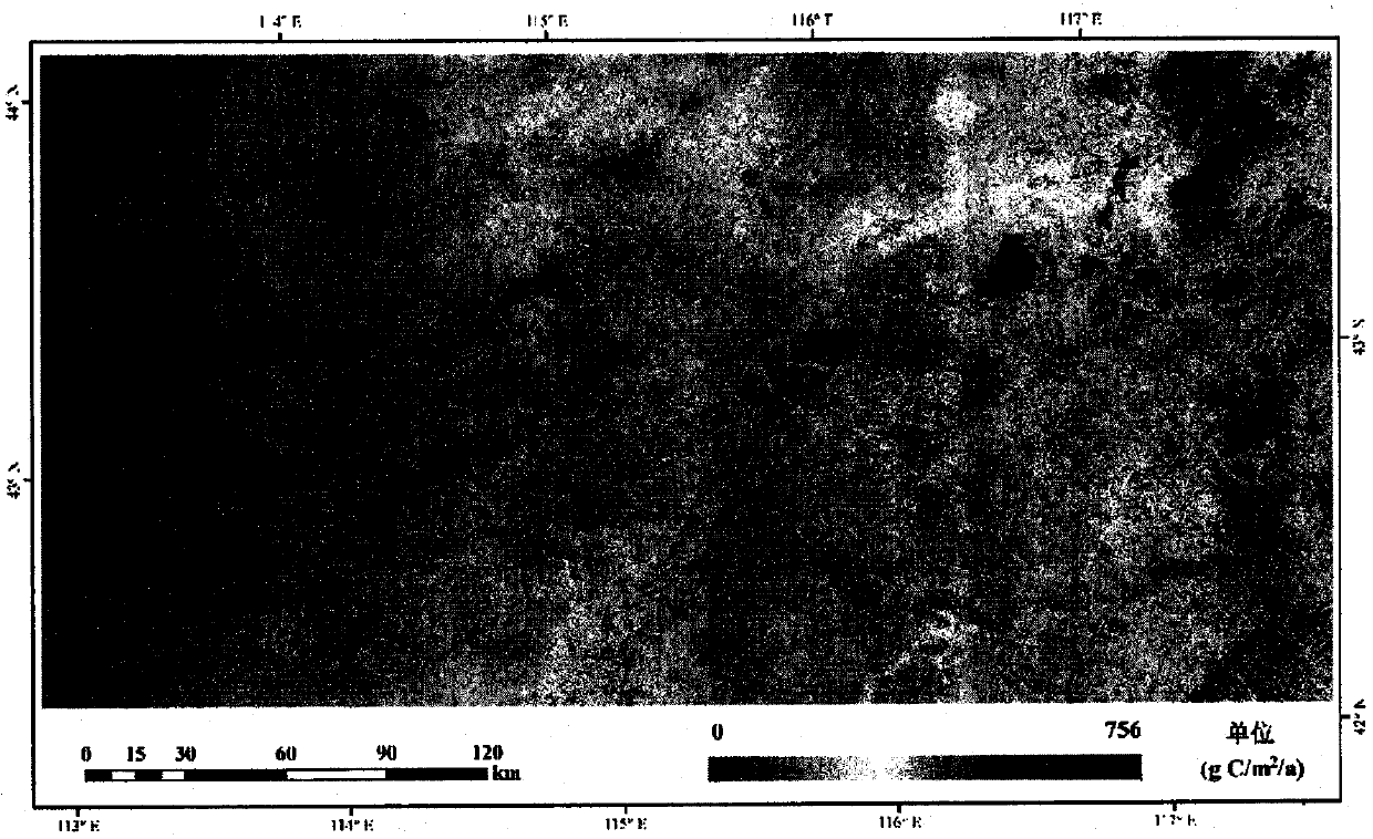
[0022] The present invention takes the Hunshandake sandy land of Xilin Gol League in Inner Mongolia as a research area, which is located at the southern end of the Xilin Gol League grassland in the central and eastern part of Inner Mongolia. Dake Sandy Land is a typical semi-arid area with a mid-temperate continental climate, about 400km from east to west, 200km from north to south, and an average altitude of about 1300m. Since this area is far away from the oc...


PUM


Abstract

The invention discloses a high-space remote sensing estimation method for soil organic carbon density in a desertification region, by optimizing main model parameters in a soil organic carbon densityestimation process, and fusing the advantage of high spatial resolution of GF-1WFV data and the advantage of high temporal resolution of MODIS data, high-space (16m) and high-precision estimation of the organic carbon density of the soil in the desertification region are realized; and by utilizing remote sensing techniques, the problem of soil organic carbon density scale extrapolation can be wellsolved; the spatial heterogeneity of the organic carbon density distribution of the soil in the sand can be reflected more finely; possibility is provided for multi-scale soil respiration long-term quantitative estimation, scientific data reference is provided for land degradation monitoring and evaluation of desertification areas and implementation work of desertification control engineering, and the application capacity of domestic remote sensing data is improved.

Description

technical field [0001] The invention relates to a method for high space remote sensing estimation of soil organic carbon density in desertification areas. Background technique [0002] At present, the phenomenon of global warming is becoming more and more significant, and the resulting climate change and its impact have attracted more and more international attention, and the research on the global and regional carbon cycle closely related to it has become a major issue in the field of global change and macro-ecology. One of the core research content of science. More than 2 / 3 of the carbon in terrestrial ecosystems is stored in soil, and soil respiration is the main way for terrestrial ecosystems to export carbon to the atmosphere, and is an important part of the carbon cycle of terrestrial ecosystems. It is estimated that soil respiration in the global terrestrial ecosystem can release (68±4)-100 Pg C of carbon into the atmosphere every year, which is about 11 times the ca...

Claims


Application Information

Patent Timeline
Patent Type & Authority Applications(China)
IPC IPC(8): G06F17/50
Inventor 孙斌高志海王燕宋张亮高文韬
Owner RES INST OF FOREST RESOURCE INFORMATION TECHN CHINESE ACADEMY OF FORESTRY
Why Eureka
Try Eureka