
Real-time dynamic monitoring method for arid region inland river basin underground water

A real-time dynamic, groundwater technology, applied in the field of water resources management, can solve problems such as waste of manpower, material resources, lack of timeliness of data, and difficult survey conditions, so as to save time and cost, realize real-time evaluation and management decision-making, and shorten data collection time Effect

Inactive Publication Date: 2019-07-19
XINJIANG INST OF ECOLOGY & GEOGRAPHY CHINESE ACAD OF SCI
View PDF4 Cites 5 Cited by
  • Summary
  • Abstract
  • Description
  • Claims
  • Application Information

AI Technical Summary

Problems solved by technology

[0005] However, the area of ​​oases with densely populated populations in the arid area only accounts for about 5% of the entire area of ​​the arid area, and the remaining nearly 95% are mountainous and desert areas, where there are few people, harsh environments, and difficult field survey conditions. , Distributed collection of groundwater level data is time-consuming, laborious, and wastes a lot of manpower and material resources, resulting in high cost, slow data update, and lack of timeliness of data

Method used


Image

  • Real-time dynamic monitoring method for arid region inland river basin underground water

Examples


Embodiment

[0033] A real-time dynamic monitoring method for groundwater in inland river basins in arid areas, comprising the following steps:

[0034] (1) Preparatory work before laying groundwater monitoring wells: collecting hydrological and geological data of the area to be monitored;

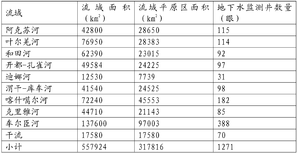
[0035] Specifically, the Tarim River Basin, the largest inland river basin in the arid region of Northwest China, was selected as the implementation area to collect relevant local hydrological and geological data, including geological maps, profile maps, geographical distribution of groundwater recharge sources and their hydrological characteristics, and hydraulic engineering facilities , distribution of aquifers, types of groundwater quality, development and utilization of groundwater resources, and regional planning distribution maps, resource development and land use, and characteristics of water pollution sources and sewage discharge.

[0036] (2) The layout principle of groundwater monitoring well...


PUM

PropertyMeasurementUnit
thicknessaaaaaaaaaa

Abstract

The invention discloses a real-time dynamic monitoring method for arid region inland river basin underground water. The method mainly comprises the steps of preparation before underground water monitoring well distribution, underground water monitoring well distribution principle determination, underground water monitoring well distribution density determination, construction of underground watermonitoring wells, arrangement of automatic water level monitoring devices and regular management of the underground water monitoring wells and surrounding facilities. According to the method, on the basis of investigating underground water conditions of different hydrogeological units in a basin, the underground water level monitoring wells covering the whole basin are distributed in the basin, intelligent water level meters are arranged in the underground water monitoring wells, data transmission terminals of the intelligent water level meters are connected to data receiving terminals througha wireless network to realize regular whole-basin real-time underground water level monitoring and remote transmission, underground water level manual collection cost is effectively lowered, data collection time is shortened, and the timeliness and accuracy of data are greatly improved.

Description

technical field [0001] The invention relates to the technical field of water resource management, in particular to a groundwater real-time dynamic monitoring technology, and more specifically to a real-time dynamic monitoring method for groundwater in inland river basins in arid areas. Background technique [0002] As an important part of the water resource system, the groundwater system is an indispensable regulator for maintaining the earth's surface water balance and maintaining biodiversity. Groundwater not only plays an important role in water supply in the sustainable economic development of arid areas, but also is one of the most important factors affecting the ecological environment in arid areas. The most intuitive manifestation of the change of the groundwater flow system is the dynamic change of the groundwater level, and the change of the groundwater will affect the regional ecosystem by changing the water cycle and water balance. [0003] Most natural vegetatio...

Claims


Application Information

Patent Timeline
Patent Type & Authority Applications(China)
IPC IPC(8): G01N33/18G01V9/02G01C13/00E21D7/00
CPCG01N33/18G01V9/02G01C13/00G01C13/008E21D7/00
Inventor 周洪华朱成刚陈亚宁陈亚鹏郝兴明
Owner XINJIANG INST OF ECOLOGY & GEOGRAPHY CHINESE ACAD OF SCI
Learn More