Multi-specification-in-one regional space planning information management platform

An information management platform and space planning technology, which is applied in the field of multi-planning regional space planning information management platform, can solve the problems of low efficiency, conflict, and confusion of space resource allocation, so as to facilitate the macroscopic overall display analysis and avoid conflicts , The effect of convenient and convenient management

Pending Publication Date: 2019-07-30
四川云华川科技有限公司
View PDF7 Cites 3 Cited by
  • Summary
  • Abstract
  • Description
  • Claims
  • Application Information

AI Technical Summary

Problems solved by technology

[0002] In the current spatial planning system of cities across the country, such as urban and rural planning, overall land use planning, environmental protection planning, forestry planning, etc., there are contradictions and conflicts between "multi-planning", resulting in low efficiency of spatial resource allocation
The main problems are: there are many kinds of data and data sources for land use planning, and there are differences in statistical methods, data forms and management methods among various departments and units. Among them, various departments include local planning and construction departments, land departments, environmental protection departments, and forestry departments. For departments with statutory spatial planning management authority, the difference in statistical methods is mainly reflected in the difference in the classification of land resources. For example, the overall planning of land use focuses on construction land, while urban and rural planning focuses on urban land. In addition, for environmental protection planning , forestry planning, and have their own statistical requirements for water source protection areas, nature reserves, forestry resources, etc.
Therefore, the combination will lead to a lot of confusion, and even when it comes to land resources, some plans will conflict with each other

Method used


Image

  • Multi-specification-in-one regional space planning information management platform
  • Multi-specification-in-one regional space planning information management platform

Examples


Embodiment 1

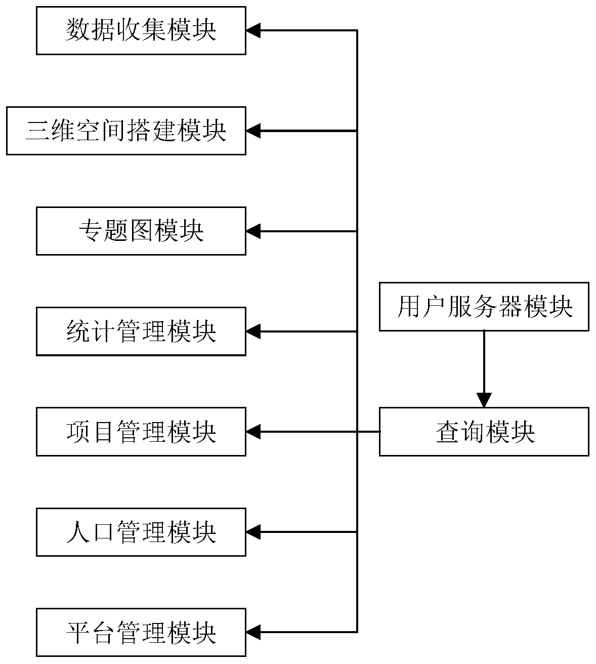
[0032] Such as figure 1 As shown, a multi-planning regional spatial planning information management platform includes a data collection module to collect regional spatial data, including the general characteristics of natural geographical elements and social and cultural elements of urban spatial terrain, and unify the collected regional spatial data ;

[0033] The three-dimensional space building module uses the collected regional spatial data to generate TIN and DEM, analyzes the relevant factors, adds the satellite remote sensing images of the original site to the GIS, and corresponds the images to the DEM model one by one, and then The superimposed image format is converted into a format that can be recognized in ARCSCANCE, and then each relevant factor is converted into a 3D model in ARCSCANCE, and the satellite image is converted into a 3D model, and they are superimposed layer by layer to form a 3D simulation model of the existing regional space ;

[0034] The user se...

Embodiment 2

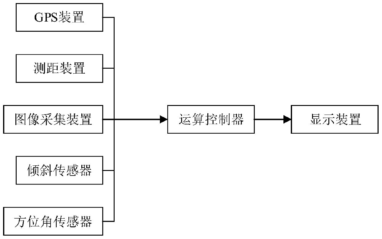
[0049] Such as figure 2 As shown, further on the basis of Embodiment 1, because the situation that data update is not timely often occurs, thereby resulting in spatial planning, the data collection module includes a geographic data collection module and a humanities data collection module; the geographic data collection module It includes a GPS device, a distance measuring device, an image acquisition device, an inclination sensor, an azimuth sensor, a display device and an operation controller, and the operation controller is respectively connected with the GPS device, the distance measurement device, an image acquisition device, an inclination sensor, an azimuth The angle sensor and the display device are connected, the GPS device is used to provide the original geographical data of the target measurement area, the distance measuring device is used to provide the real-time distance data of the target measurement area, and the image acquisition device is used to provide the t...


PUM


Abstract

The invention discloses a multi-specification-in-one regional space planning information management platform, which comprises a data collection module for collecting regional space data, including general characteristics of natural geographic elements and social human factors of urban space topography, and unifying the collected regional space data. According to the method, planning of environmentplanning, urban and rural planning, municipal planning and the like is integrated, and Multi-specification-in-one is achieved; according to the scheme, after the site is subjected to three-dimensional modeling, various kinds of comprehensive information such as geographic information, land natural resource information and population information of the site can be obtained at will, and convenienceis brought to government departments; the scheme has a data service function, has a concise and detailed display platform, and is convenient for a user to macroscopically and integrally display and analyze global data; the scheme pays attention to real-time updating of the data, and timely eliminates the expired data information.

Description

technical field [0001] The invention belongs to the technical field of space planning, and in particular relates to an information management platform for multi-plan integration regional space planning. Background technique [0002] The current spatial planning systems of cities across the country, such as urban and rural planning, overall land use planning, environmental protection planning, forestry planning, etc., have contradictions and conflicts between "multi-plans", resulting in low efficiency of spatial resource allocation. The main problems are: there are many kinds of data and data sources for land use planning, and there are differences in statistical methods, data forms and management methods among various departments and units. Among them, various departments include local planning and construction departments, land departments, environmental protection departments, and forestry departments. For departments with statutory spatial planning management authority, t...

Claims


Application Information

Patent Timeline
Patent Type & Authority Applications(China)
IPC IPC(8): G06F17/50G06F16/29G06Q50/26
CPCG06F16/29G06Q50/26G06F30/20
Inventor 岳伟
Owner 四川云华川科技有限公司
Why Eureka
Try Eureka