Unmanned aerial vehicle measurement method for digital elevation model of terrain image

A digital elevation model and unmanned aerial vehicle technology, applied in the field of surveying and mapping, can solve the problems of unsuitable construction of large-scale, full-coverage CORS system, high-precision range that cannot completely cover the entire area, and high input cost, so as to shorten the surveying and mapping task cycle. , The effect of high business level requirements and low investment in manpower and material costs

Active Publication Date: 2019-08-16
抚顺市规划勘测设计研究院有限公司
View PDF6 Cites 7 Cited by
  • Summary
  • Abstract
  • Description
  • Claims
  • Application Information

AI Technical Summary

Problems solved by technology

Although the accuracy requirements are met in a large range, the required investment is also huge. If the distribution density is reduced, the high-precision range provided by the system cannot completely cover the entire area
The CORS system has been widely used in some economically developed cities in the south, but because it requires multiple fixed base

Method used


Image

  • Unmanned aerial vehicle measurement method for digital elevation model of terrain image
  • Unmanned aerial vehicle measurement method for digital elevation model of terrain image

Examples


Embodiment 1

[0041] An unmanned aerial vehicle surveying and mapping method for digital elevation models of terrain images, comprising:

[0042] S1. According to the shape and area of ​​the target area, determine the route and flight height of the surveying and mapping UAV, deploy and control the mobile reference station, and form a signal coverage network of the reference station;

[0043] In the target area, set an image control point every 100-1000m;

[0044] S2. Release the surveying and mapping UAV and the ground accompanying positioning device. The ground accompanying positioning device moves forward along the geometric centerline of the surveying and mapping UAV route. The positioning mark point of human-machine identification; the RTK positioning device sends the coordinates and elevation information of the ground accompanying positioning device to the mobile reference station during the movement;

[0045] The surveying and mapping UAV flies at high altitude, and the ground moves ...

Embodiment 2

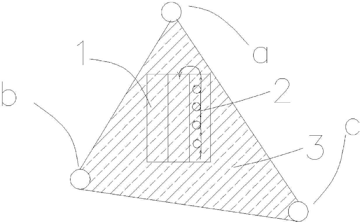
[0060] Such as figure 1 As shown, a hilly area in a central province is surveyed and mapped. The surveyed area is about 8km long from north to south and about 6km long from east to west. Delineate a surveying and mapping UAV route 2 with a circling curve (the circling direction shown by the arrow in the figure), and use a manned all-terrain vehicle as a ground companion positioning device carrying platform.

[0061] After preliminary calculations, the flying height of the surveying and mapping drone is 600m, which can meet the requirements of the field of view of surveying and mapping; on the high point near the route of the surveying and mapping drone, an image control point is manually set every 100-500m.

[0062] When the light is sufficient, there is no rainfall, and the wind force is less than level 4, the operator sends a helicopter to set up three mobile reference stations a, b, and c on the peaks on both sides of the canyon, forming a triangular CORS reference station ...

Embodiment 3

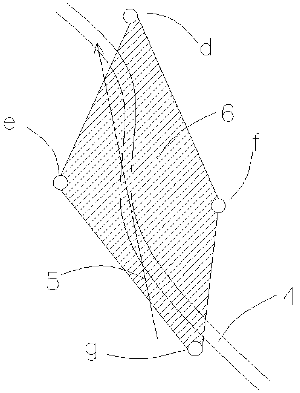
[0068] Such as figure 2 As shown, a long and narrow riverside 4 area in an eastern province is surveyed and mapped. The area is about 60km long and 1.2km wide. The flying height of the surveying and mapping UAV is set to 520 meters to meet the requirements of the surveying and mapping field of view; A mapping drone route5. The motorboat in the river is used as the platform for the RTK positioning device, and the motorboat is equipped with positioning mark points.

[0069] When the light is sufficient, there is no rainfall, and the wind force is less than grade 4, the operator sends a helicopter to set up four mobile reference stations d, e, f, and g at the high points along the river banks to form a quadrilateral CORS reference station signal coverage network 6 and release surveying and mapping At the same time, the motorboat moves continuously and smoothly along the river at 80km / s.

[0070] On the basis of the method in Example 2, the terrain image digital elevation model...


PUM


Abstract

The present invention relates to an unmanned aerial vehicle measurement method for a digital elevation model of a terrain image, comprising steps of determining a route and a flight height of the unmanned aerial vehicle according to shape and area of a target area, deploying and controlling a mobile reference station to form a CORS reference station signal coverage network; and then releasing a measurement unmanned aerial vehicle and a ground accompanying positioning device, and acquiring photos, coordinates, elevation and other information, afterwards using Smart3D technology to synthesize the photos into a three-dimensional image model; arranging the surface of the generated three-dimensional image model according to a regular network structure and extracting sampling points, establishing a DEM by interpolating the sampling points; coding new sample points according the known geographic elevation information, and interpolating and correcting to form the digital elevation model of terrain image with a higher precision. The unmanned aerial vehicle measurement method of the invention replaces photo control points or physical points with the ground accompanying positioning device, eliminating the trouble of manually deploying and controlling photo control points, increasing the arrangement density of the positioning points and improving the measurement accuracy. The accuracy canreach 1-3cm for part of features points in the target area.

Description

technical field [0001] The invention belongs to the field of surveying and mapping, in particular to an unmanned aerial vehicle surveying and mapping method for digital elevation models of terrain images. Background technique [0002] Digital elevation model (Digital Elevation Model), referred to as DEM. It is a solid ground model that expresses the ground elevation in the form of a set of ordered numerical arrays, and is a branch of the Digital Terrain Model (DTM), from which various other terrain feature values ​​can be derived. It is generally believed that DTM describes the spatial distribution of various geomorphic factors including elevation, such as slope, slope aspect, slope change rate and other factors including linear and nonlinear combinations, and DEM is a zero-order simple single-item digital geomorphic model , other landform characteristics such as slope, aspect and slope change rate can be derived on the basis of DEM. [0003] Since DEM describes ground ele...

Claims


Application Information

Patent Timeline
IPC IPC(8): G01C11/00G01C5/00G01S19/43
CPCG01C11/00G01C5/00G01S19/43
Inventor 纪学超高飞飞顾宝州张静
Owner 抚顺市规划勘测设计研究院有限公司
Why Eureka
Try Eureka